World Heritage Identification Number: 1718
World Heritage since: 2024
Category: Cultural Heritage
WHE Type: Archaeological Sites
Transboundary Heritage: No
Endangered Heritage: No
Country: 🇷🇴 Romania
Continent: Europe
UNESCO World Region: Europe and North America
Map
The Frontiers of the Roman Empire – Dacia: A Fortified Landscape of Ancient Rome
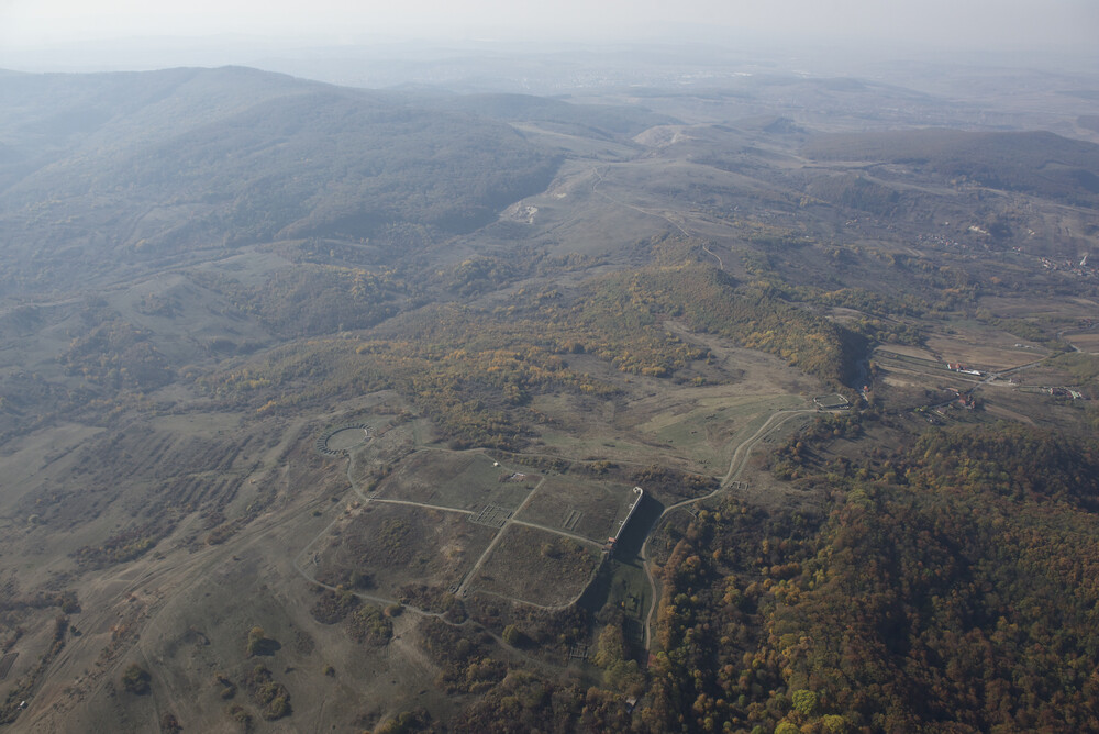
The Frontiers of the Roman Empire – Dacia, inscribed in 2024, offers a unique glimpse into the expansive territorial reach of ancient Rome. This extensive property encompasses 277 component parts, representing the longest and most intricate land border of any former Roman province in Europe. Stretching over approximately 1,000 kilometers, the Dacian Limes served as the defensive barrier for the Roman province of Dacia, located entirely north of the Danube River.
More to come…UNESCO Description of the World Heritage Site
From 500 BCE on, the Roman Empire extended its territory across parts of Europe and North Africa until its frontier totaled some 7,500 kilometres by the 2nd century. The Romanian segment, the Dacian Limes, was operational from 106 to 271 CE. The property comprises 277 component parts and represents the longest, most complex land border of a former Roman province in Europe. Traversing diverse landscapes, it is defined by a network of individual sites that include legionary fortresses, auxiliary forts, earthen ramparts, watch towers, temporary camps and secular buildings. Dacia was the only Roman province entirely north of the Danube River. Its frontier protected it from ‘barbarian’ populations and controlled access to valuable gold and salt resources.
UNESCO Justification of the World Heritage Site
Criterion (ii): The extant remains of Frontiers of the Roman Empire – Dacia constitute significant elements of the Roman frontiers in Europe. The serial property exhibits an important interchange of human and cultural values at the height of the Roman Empire, through the development of Roman military architecture, extending the technical knowledge of construction and management to the very edges of the empire. It reflects the imposition of a complex frontier system on the existing societies of the northern part of the Roman Empire, introducing military installations and related civilian settlements, linked through an extensive supporting network. The frontier did not constitute an impregnable barrier, but controlled and allowed the movement of peoples. This entailed profound changes and developments in terms of settlement patterns, architecture and landscape design and spatial organisation.
Criterion (iii): As part of the Roman Empire’s general system of defence, Frontiers of the Roman Empire – Dacia bears an exceptional testimony to the maximum extension of the power of the Roman Empire through the consolidation of its northern frontiers and constitutes a physical manifestation of Roman imperial policy. The property illustrates the Roman Empire’s ambition to dominate the world in order to establish its law and way of life in a long-term perspective. It demonstrates the processes of Roman colonisation in its territories, the spread of Roman culture and its different traditions – military, engineering, architecture, religion, management and politics. The large number of human settlements associated with the defences contribute to an understanding of how soldiers and their families lived in this part of the Roman Empire.
Criterion (iv): The Frontiers of the Roman Empire – Dacia is a remarkable example of Roman military architecture and technological development. The property testifies to the versatility and sophistication of the Roman response to specific topography and climate, set against the political, military and social backdrop of the time in the northern part of the empire. Stretching for more than a thousand kilometres, it is the largest segment of the Frontiers of the Roman Empire. It comprises both land and riverine sectors, characterised by varying types, locations and densities of military installations distributed across the landscape. Fortifications of different sizes, set at irregular intervals, artificial linear barriers (stone walls, earthworks), natural barriers (mountain ranges, rivers), packed or sparse networks of watchtowers were all integrated within the same provincial border. The Dacian frontier exhibits numerous structural changes throughout its nearly 170 years of existence allowing insight into an important timeline in the history of the Roman Empire.
Encyclopedia Record: Dacian Limes
The Dacian Limes is the generic modern term given to a collection of ramparts and linked series of Roman forts on the frontiers of the Roman province of Dacia dating from the early 2nd century AD. They ran for about 1,000 km and included the:Limes Alutanus on the eastern side of the Olt river Limes Porolissensis Limes Transalutanus in Wallachia so-called Trajan's Walls between Constanța and the Danube including: Lower Trajan's Wall or Athanaric's Wall just north of the Danube delta in Moldova Upper Trajan's Wall or Greuthungi Wall in central Moldova from the Prut to the Dniester rivers, although they may not have been Roman Constantine Wall, or Brazda lui Novac de Nord in Walachia from around 330 AD and 300 km long.Additional Site Details
Area: 1,491.6 hectares
Number of Components: 277
(iii) — Unique or exceptional testimony to a cultural tradition
(iv) — Outstanding example of a type of building or landscape
Coordinates: 47.1807888889 , 23.1594111111
Image
© National Museum of Transylvani an History. Used with permission.
