World Heritage Identification Number: 977
World Heritage since: 2000
Category: Cultural Heritage
WHE Type: Archaeological Sites
Transboundary Heritage: No
Endangered Heritage: No
Country: 🇰🇷 Republic of Korea
Continent: Asia
UNESCO World Region: Asia and the Pacific
Map
The Prehistoric Cemeteries of Gochang, Hwasun, and Ganghwa Dolmen Sites
The Gochang, Hwasun, and Ganghwa Dolmen Sites, collectively referred to as the Three Dolmen Sites, are a group of prehistoric cemeteries located in South Korea. These sites, inscribed as a UNESCO World Heritage Site in 2000, are significant for their concentration of dolmens, a type of megalithic structure that dates back to the 1st millennium BCE.
More to come…UNESCO Description of the World Heritage Site
The prehistoric cemeteries at Gochang, Hwasun, and Ganghwa contain many hundreds of examples of dolmens - tombs from the 1st millennium BC constructed of large stone slabs. They form part of the Megalithic culture, found in many parts of the world, but nowhere in such a concentrated form.
UNESCO Justification of the World Heritage Site
Criterion (iii): The global prehistoric technological and social phenomenon that resulted in the appearance in the 2nd and 3rd millennia BCE of funerary and ritual monuments constructed of large stones (the Megalithic Culture) is nowhere more vividly illustrated than in the dolmen cemeteries of Gochang, Hwasun, and Ganghwa.
Encyclopedia Record: Gochang, Hwasun and Ganghwa Dolmen Sites
The Gochang, Hwasun and Ganghwa Dolmen Sites are the location of hundreds of stone dolmens which were used as grave markers, and for ritual purposes during the first millennium BCE when the Megalithic Culture was prominent on the Korean Peninsula. The sites were designated as a World Heritage Site by UNESCO in 2000. The Korean Peninsula is home to over 35,000 dolmens, accounting for approximately 40% of the world's total; the Gochang, Hwasun, and Ganghwa sites are themselves home to over 1,000 dolmens.Additional Site Details
Area: 51.65 hectares
Number of Components: 3
Coordinates: 34.96667 , 126.92917
Image
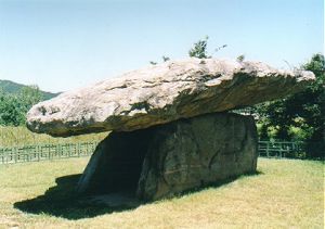
© Elswhs at Dutch Wikipedia (Original text: Els Slots), CC BY-SA 3.0 Resized from original. (This derivative is under the same CC BY-SA license.)
World Heritage Research
Discover scientific research and academic studies that deepen our understanding of Gochang, Hwasun and Ganghwa Dolmen Sites from its history and significance to its conservation, management, and contemporary challenges.
-
Quantitative Assessment of Social Stratification and Inequality in the Late Bronze Age and Early Iron Age South Korea
A quantitative analysis of dolmen volume distributions in southeastern Gochang, South Korea, reveals moderate social stratification and inequality during the Late Bronze Age and Early Iron Age. The study found that dolmen sizes follow a power-law distribution with a scaling exponent (α) of approximately 3.26, indicating a relatively egalitarian structure where few large dolmens dominate without overwhelming disparity. Complementary measures—the Gini coefficient (~0.537) and the 20/80 rule (~57.9%)—support this finding. Spatial analysis further shows that while the southeastern cluster is internally cohesive, it remains loosely connected to the broader Gochang dolmen network, suggesting a peripheral social organization within a larger system.
Noh, Y., & Kim, S. (2026). Quantitative Assessment of Social Stratification and Inequality in the Late Bronze Age and Early Iron Age South Korea. Archaeometry. Portico. https://doi.org/10.1111/arcm.70161
View Publication Record | Read Publication -
Current Status and Future Tasks of Conservation and Management for World Heritage Gochang Dolmens
Gochang Dolmens has demonstrated significant conservation achievements over the past 25 years since its inscription. The site's preservation efforts, including the expansion of protected areas and the relocation of residents to maintain authenticity, have set a global benchmark for heritage management. However, the study reveals critical challenges: an overwhelming dominance of domestic tourists (99%), seasonal dependency on events like the Cheongbori Field Festival, and a sluggish post-pandemic recovery in visitor numbers compared to other sites. To overcome these limitations, the research proposes five key strategies for sustainable development: integrating conservation across broader dolmen sites, leveraging national cultural policies for regional revitalization, enhancing global marketing through multilingual resources and international networks, developing immersive digital experiences like AR/VR to diversify audiences, and fostering participatory governance that includes local communities. This approach aims to transform Gochang Dolmens into a dynamic, globally accessible heritage asset that transcends its current constraints.
Jang, C.-h. (2026). Current Status and Future Tasks of Conservation and Management for World Heritage Gochang Dolmens. Journal of School Social Work, 102(0), 5–49. https://doi.org/10.37924/jssw.102.1
View Publication Record | Read Publication -
Dolmen UNESCO Sites Are Tourism Attractions in Korea: Semiotics of Sustainability for Cultural Heritage
Semiotic analysis reveals that the Dolmen UNESCO Sites in Gochang, Hwasun, and Ganghwa maintain sustainability through nuanced articulations of denotative signs and connotative signifiers, reflecting a unique Korean management style that embraces paradox. This approach supports the sites' identity as cultural tourism attractions by balancing national heritage, community-based tourism, and government support. The findings demonstrate how these sites sustain an unbroken link to Korea's neolithic past while diversifying their narrative within sustainable tourism frameworks.
Hunter, W. C. (2025). Dolmen UNESCO Sites Are Tourism Attractions in Korea: Semiotics of Sustainability for Cultural Heritage. Sustainability, 17(17), 8021. https://doi.org/10.3390/su17178021
View Publication Record | Read Publication -
Digital Restoration of the Heritage Landscape through a GIS-Based Approach: Case Study of the Gochang Dolmen Site in South Korea
A GIS-based approach reveals the Gochang Dolmen Site's broader prehistoric landscape, including lost or marginalized megalithic features, challenging monument-centric heritage narratives. By integrating national heritage data with 3D visualizations, researchers reconstruct displaced or damaged dolmens, offering new insights into South Korea’s cultural history and aligning with digital heritage management policies. This method not only supports conservation but also democratizes heritage discourse by reintegrating absent sites into public memory.
Zoh, M., Shim, W., & Ko, I. (2025). Digital Restoration of the Heritage Landscape through a GIS-Based Approach: Case Study of the Gochang Dolmen Site in South Korea. The International Archives of the Photogrammetry, Remote Sensing and Spatial Information Sciences, XLVIII-M-9-2025, 1729–1734. https://doi.org/10.5194/isprs-archives-xlviii-m-9-2025-1729-2025
View Publication Record | Read Publication -
Distribution and Characteristics of Table-Type Dolmens in Ganghwa Island and the Hangang River Basin
Table-type dolmens, characterized by their flat-topped stone structures, are more prevalent than individual stone dolmens (개석식) on Ganghwa Island, constituting 55% of the total. These dolmens are predominantly located along ridges (77%) and hills (18%), with only a small percentage found in flatlands (5%). In contrast, the Hangang River Basin exhibits distinct regional variations: the main Hangang River has 24% table-type dolmens, mostly situated in flatlands, while the North Han River Basin shows an even higher proportion (26%) of such structures. However, the South Han River Basin stands out with only 5% table-type dolmens, suggesting a unique cultural or environmental influence. The study proposes that Ganghwa Island's dolmen culture likely spread from the Yellow Sea region and possibly influenced neighboring areas like the Imjin River Basin. Additionally, the research suggests that the North Han River Basin's dolmen culture may have been influenced by the upper Han River (Han-tan) region, further propagating to the main Hangang and South Han River Basins.
Woo, J.-M. (2025). Distribution and Characteristics of Table-Type Dolmens in Ganghwa Island and the Hangang River Basin. The Journal of Korean Petroglyph, 28, 65–96. https://doi.org/10.54494/kpra.2025.28.3
View Publication Record | Read Publication -
A comparison of dolmens in Ganghwa Island and Liaodong Peninsula
Dolmens from Ganghwa Island and the Liaodong Peninsula share formal similarities, including table-like and flat-topped structures, despite geographical and cultural differences. These megalithic tombs, dating to the Bronze Age, symbolize sociopolitical authority in Northeast Asia. Ganghwa's dolmens, concentrated on the island's northern region, reflect the formation of chieftain societies during Korea's Bronze Age, while Liaodong's dolmens mark the cultural foundation for early Korean states like Gojoseon, Goguryeo, and Baekje. The study highlights Ganghwa's strategic position at the intersection of southern and northern Korean cultures, contrasting with Liaodong's dolmens, which are geographically bounded by the Yalu River to the west and the First Songhua River to the north. This comparative analysis underscores the significance of these sites in understanding the origins of political structures in early Korean history.
Yu, T.-Y. (2025). A comparison of dolmens in Ganghwa Island and Liaodong Peninsula. The Journal of Korean Petroglyph, 28, 97–153. https://doi.org/10.54494/kpra.2025.28.4
View Publication Record | Read Publication -
The Characteristics of Dolmens in the Midwest -Focusing on the Large Table-type Dolmens in the Northwest Korea and Ganghwa regions-
Large table-type dolmens in Ganghwa, Gochang, and Hwasun regions exhibit distinct characteristics that reflect shared cultural practices with Northwest Korea. These dolmens, defined by covering stones measuring over 450 cm in length and 25 tons in weight, often feature geometric ratios and turtle-shaped covers symbolizing longevity, particularly concentrated along the Han River. Unlike clustered distributions in other regions, Ganghwa's dolmens are predominantly solitary, perched on low-lying ridges or hillslopes between Mt. Goryeosan and Mt. Bongchonsan. Structural innovations, such as counterbalance tilting for stability and varied construction techniques using mortise joints, highlight advanced megalithic engineering. Archaeological findings, including bronze artifacts and pottery like spindle-shaped ceramics, suggest cultural continuity with Northwest Korea while revealing local adaptations. These insights expand the understanding of dolmen culture's regional scope, temporal phases, and symbolic significance.
Kim, J.-O. (2025). The Characteristics of Dolmens in the Midwest -Focusing on the Large Table-type Dolmens in the Northwest Korea and Ganghwa regions-. The Journal of Korean Petroglyph, 28, 5–32. https://doi.org/10.54494/kpra.2025.28.1
View Publication Record | Read Publication