World Heritage Identification Number: 1264
World Heritage since: 2007
Category: Natural Heritage
WHE Type: Natural Landscapes & Geographic Features
Transboundary Heritage: No
Endangered Heritage: No
Country: 🇰🇷 Republic of Korea
Continent: Asia
UNESCO World Region: Asia and the Pacific
Map
Exploring the Natural Wonders of Jeju Volcanic Island and Lava Tubes
The Jeju Volcanic Island and Lava Tubes, located off the southern coast of South Korea, is a unique and captivating UNESCO World Heritage Site. This designation recognizes the island's exceptional geological features, particularly the Geomunoreum Lava Tube System, which showcases a remarkable display of volcanic phenomena.
More to come…UNESCO Description of the World Heritage Site
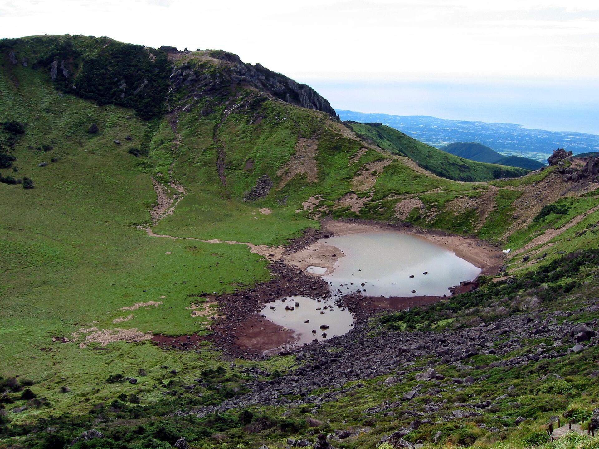
Jeju Volcanic Island and Lava Tubes together comprise three sites that make up 18,846 ha. It includes Geomunoreum, regarded as the finest lava tube system of caves anywhere, with its multicoloured carbonate roofs and floors, and dark-coloured lava walls; the fortress-like Seongsan Ilchulbong tuff cone, rising out of the ocean, a dramatic landscape; and Mount Halla, the highest in Korea, with its waterfalls, multi-shaped rock formations, and lake-filled crater. The site, of outstanding aesthetic beauty, also bears testimony to the history of the planet, its features and processes.
UNESCO Justification of the World Heritage Site
Criterion (vii): The Geomunoreum lava tube system, which is regarded as the finest such cave system in the world, has an outstanding visual impact even for those experienced with such phenomena. It displays the unique spectacle of multi-coloured carbonate decorations adorning the roofs and floors, and dark-coloured lava walls, partially covered by a mural of carbonate deposits. The fortress-like Seongsan Ilchulbong tuff cone, with its walls rising out of the ocean, is a dramatic landscape feature, and Mount Halla, with its array of textures and colours through the changing seasons, waterfalls, display of multi-shaped rock formations and columnar-jointed cliffs, and the towering summit with its lake-filled crater, further adds to the scenic and aesthetic appeal.
Criterion (viii): Jeju has a distinctive value as one of the few large shield volcanoes in the world built over a hot spot on a stationary continental crust plate. It is distinguished by the Geomunoreum lava tube system, which is the most impressive and significant series of protected lava tube caves in the world and includes a spectacular array of secondary carbonate speleothems (stalactites and other decorations), with an abundance and diversity unknown elsewhere within a lava cave. The Seongsan Ilchulbong tuff cone has exceptional exposures of its structural and sedimentological characteristics, making it a world-class location for understanding Surtseyan-type volcanic eruptions.
Encyclopedia Record: Jeju Volcanic Island and Lava Tubes
The Jeju Volcanic Island and Lava Tubes is a World Heritage Site in Jeju Province, South Korea. It was inscribed as one of the UNESCO World Heritage Sites in 2007 because of the Geomunoreum Lava Tube System and the exhibition of diverse and accessible volcanic features which are considered to demonstrate a distinctive and valuable contribution to the understanding of global volcanism.Additional Site Details
Area: 9,521.8 hectares
Number of Components: 7
(viii) — Outstanding example representing major earth stages
Coordinates: 33.4688888889 , 126.7202777777
IUCN World Heritage Outlook
The 2025 Conservation Outlook on Jeju Volcanic Island and Lava Tubes reports the following assessment:
Source: International Union for Conservation of Nature (IUCN) · View assessment
Image
Unknown, Public domain
World Heritage Research
Discover scientific research and academic studies that deepen our understanding of Jeju Volcanic Island and Lava Tubes from its history and significance to its conservation, management, and contemporary challenges.
-
Characteristics of vegetation according to the micro-climatic conditions of a lava pit on Jeju Island
Vegetation characteristics on Jeju Island's Geomunoreum lava tube system vary significantly with microclimatic conditions. The study found that areas with stable temperature and humidity, such as the lower pit (plot 3) and outer flattening-out regions (plots 6 and 7), exhibit simpler vegetation structures with high mortality and low growth rates in the former, while the latter shows diverse competing species and high growth rates. Midpoint areas (plots 2 and 4) display transitions in dominant tree species but stable shrub and subtree layers. Higher areas (plots 1 and 5) show frequent changes across all vegetation layers. These patterns differ from other lava pits on the island, highlighting the unique microclimatic influence on vegetation structure and dynamics.
Park, E.-H., Yang, J.-E., Park, M., Kwak, S., Lee, B., & Seol, A. (2023). Characteristics of vegetation according to the micro-climatic conditions of a lava pit on Jeju Island. https://doi.org/10.5194/egusphere-egu23-11142
View Publication Record | Read Publication -
Landforms in Old Landscape Paintings of Jeju Island, Korea, and Their Implications of Geomorphological Perception
A historical analysis of Jeju Island's landscape paintings reveals the first documented collection of significant geomorphological features, including volcanic edifices, lava tubes, fluvial landforms, and coastal structures. The study, based on Governor Lee Iktae's 1695 series 'Ten Scenic Views of Jeju,' highlights how these artworks captured both local and mainland perspectives, establishing enduring stereotypes for Jeju's landscapes. It also underscores the underestimation of certain features like lava tubes due to cultural perceptions and the limited inclusion of ecologically important landforms, reflecting the evaluation criteria of the time.
Kim, T. (2022). Landforms in Old Landscape Paintings of Jeju Island, Korea, and Their Implications of Geomorphological Perception. https://doi.org/10.5194/icg2022-319
View Publication Record | Read Publication -
Session 2.1 Jeju volcanic island and lava tubes
Jeju Volcanic Island and Lava Tubes, a National Park off South Korea's southern coast, presents a unique case study in balancing tourism growth with environmental sustainability. The island, formed by volcanic activity hundreds of thousands of years ago, is renowned for its lava tubes, beaches, and cultural heritage, including three UNESCO World Heritage Sites. However, rapid tourism development poses challenges such as increased pollution, energy demands, and transportation strains, particularly given the island's limited urban infrastructure with only two cities. The study highlights the need for sustainable strategies to mitigate these impacts while preserving the island's natural and cultural assets.
Godsey, N., Grau, N., & Cookson, J. (2022). Session 2.1 Jeju volcanic island and lava tubes. “Road Home” from Glasgow Youth Summit; Voices of Optimism and Agents of Change. https://doi.org/10.37099/mtu.dc.yeah-conference/dec2021/all-events/4
View Publication Record | Read Publication -
The Survey of Lava Tube Distribution in Jeju Island by Multi-Source Data Fusion
Researchers have identified potential lava tube networks on Jeju Island, Korea, using multi-source data fusion techniques, including Interferometric Synthetic Aperture Radar (InSAR) time series analysis and machine learning algorithms. The study detected deformations up to 10 mm/year over a three-year period, validating findings through geophysical and ground surveys. These discoveries highlight the risks of cave collapses in lava tubes, posing significant threats to planned infrastructure development on the island. The approach used in this study could also be applied to detect similar risks on planetary surfaces, offering insights for both terrestrial and extraterrestrial exploration.
Kim, J.-R., Lin, S.-Y., & Oh, J.-W. (2022). The Survey of Lava Tube Distribution in Jeju Island by Multi-Source Data Fusion. Remote Sensing, 14(3), 443. https://doi.org/10.3390/rs14030443
View Publication Record | Read Publication -
Conceptualizing a multi‐layered shingle aquifer model based on volcanic stratigraphy and water inflow to lava caves in Jeju Island, Korea
A multi-layered shingle aquifer model, constrained by volcanic stratigraphy and palaeosol layers, has been conceptualized for Jeju Island's lava tube caves. This model reveals that water inflow to caves is primarily driven by storm-induced discharge from exposed palaeosol layers on cave walls, rather than ceiling drips. Monthly monitoring over a year confirmed the substantial contribution of wall inflow, with rapid drainage through cave floors observed at all sites. The study identified the lateral extent of palaeosol layers using drill core logs and coastal outcrops, suggesting that multiple perched aquifers form between lava flows during volcanic hiatuses, connected vertically by discontinuities in these low-permeability layers. This model improves understanding of groundwater recharge, flow, and contaminant transport in volcanic aquifers, offering a more accurate representation than previous models and aiding in better groundwater management.
Ahn, U. S., Koh, D.-C., Heo, J., Cho, B.-W., Kim, T., & Yum, B.-W. (2021). Conceptualizing a multi‐layered shingle aquifer model based on volcanic stratigraphy and water inflow to lava caves in Jeju Island, Korea. Hydrological Processes, 35(8). Portico. https://doi.org/10.1002/hyp.14316
View Publication Record | Read Publication -
Quaternary lava tubes distribution in Jeju Island and their potential deformation risks
Jeju Island, a volcanic wonder formed by Quaternary eruptions, harbors a complex network of 178 lava tubes, many still undiscovered. A study reveals that these underground cavities pose significant deformation risks, particularly during nearby construction, with ground surface deformations measured at up to 2 mm/year using InSAR techniques. The research found no correlation between lava tube distribution and specific geological units, but identified high collapse risks in areas with ongoing artificial developments. Machine learning applications further confirmed the instability of shallow lava cavities, underscoring the need for thorough physical exploration and risk assessment before intensive construction projects proceed.
Kim, J., Lin, S.-Y., & Oh, J.-w. (2020). Quaternary lava tubes distribution in Jeju Island and their potential deformation risks. https://doi.org/10.5194/nhess-2020-321
View Publication Record | Read Publication -
Geotourism in Jeju Island UNESCO Global Geopark, South Korea
Jeju Island, recognized as a UNESCO Global Geopark since 2010 and revalidated in 2014, showcases diverse volcanic geosites that include cinder cones, tuff cones, lava domes, and lava tube caves. Additionally, it features a Pleistocene fossil site and a Holocene carbonate beach composed of algal nodules. The study highlights the conservation efforts, monitoring practices, and sustainable development programs implemented within the geopark to protect these unique geological formations while promoting education and geotourism. These initiatives aim to balance preservation with visitor engagement, ensuring the long-term sustainability of Jeju Island's natural heritage.
Jeon, Y., & Woo, K. S. (2018). Geotourism in Jeju Island UNESCO Global Geopark, South Korea. Handbook of Geotourism. https://doi.org/10.4337/9781785368868.00038
View Publication Record | Read Publication -
19th International Corrosion Congress
Jeju Volcanic Island and Lava Tubes, a UNESCO World Natural Heritage Site, hosted the 19th International Corrosion Congress (ICC), highlighting its unique geological significance. The congress, organized by the Corrosion Science Society of Korea (CSSK) on behalf of the International Corrosion Council, brought together experts to discuss advancements in corrosion science and technology. Jeju's volcanic origins, scenic beauty, and diverse ecosystem make it a globally recognized destination for both tourism and scientific research. The event was supported by Korean companies and the government, underscoring its importance in the field. The ICC took place at the International Convention Centre, a striking glass-wall structure perched on a cliff overlooking the Pacific Ocean, which further emphasized Jeju's natural and architectural allure.
Mills, D. J., Jamali, S., & Bingham, R. (2015). 19th International Corrosion Congress. Corrosion Engineering, Science and Technology, 50(2), 84–89. https://doi.org/10.1179/1478422x15z.000000000336
View Publication Record | Read Publication