World Heritage Identification Number: 1572
World Heritage since: 2018
Category: Cultural Heritage
WHE Type: Archaeological Sites
Transboundary Heritage: No
Endangered Heritage: No
Country: 🇹🇷 Türkiye
Continent: Asia
UNESCO World Region: Europe and North America
Map
Unraveling the Mysteries of Göbekli Tepe: A Prehistoric Sanctuary in South-Eastern Anatolia
In the heart of the Germuş mountains, nestled within the verdant landscape of south-eastern Anatolia, lies the enigmatic archaeological site of Göbekli Tepe. This remarkable Pre-Pottery Neolithic settlement, dating back approximately 11,500 years —millennia before Stonehenge or the Egyptian pyramids— has captivated scholars and enthusiasts alike since its discovery in the mid-1990s. Inscribed as a UNESCO World Heritage Site in 2018, Göbekli Tepe offers a unique glimpse into the lives, beliefs, and artistic achievements of early human communities.
Although the mound had been noted during archaeological surveys in the 1960s, its extraordinary significance was only recognized in 1994 by the German archaeologist Klaus Schmidt. Working in collaboration with the German Archaeological Institute and the Şanlıurfa Museum, Schmidt initiated systematic excavations that soon revealed a complex of monumental stone structures unlike anything previously known from the early Neolithic period.
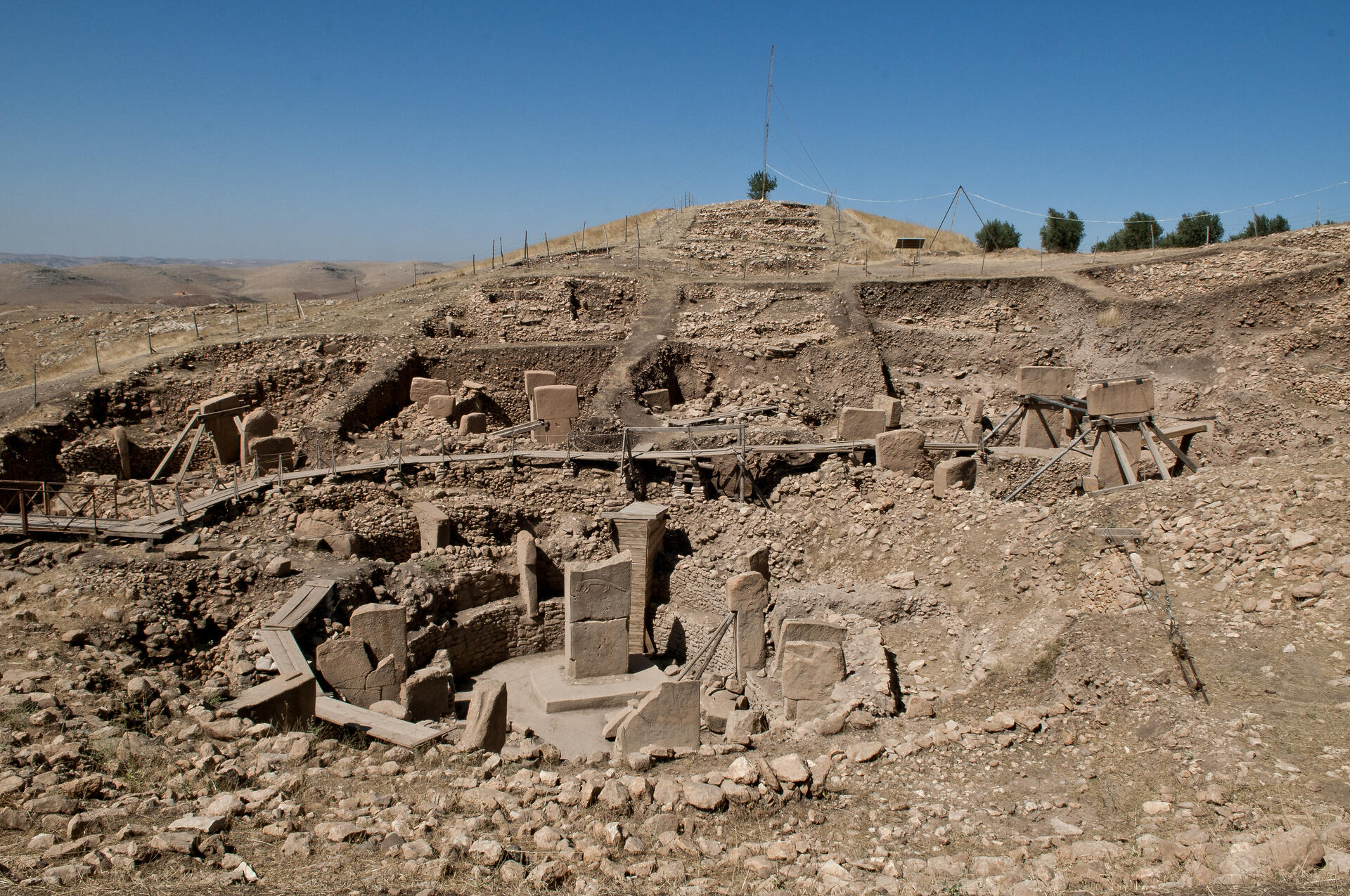
The property comprises a series of monumental circular and rectangular megalithic enclosures that testify to the ingenuity and organizational abilities of communities living in the region between roughly 9,600 and 8,200 BCE. These structures, among the world’s oldest known megalithic constructions, are widely interpreted as having served ceremonial or ritual purposes for groups that were primarily hunter-gatherers. While long interpreted as purely ceremonial spaces, recent discoveries of possible domestic structures and water-management features suggest the site may also have supported more sustained human activity.
One of the most striking features of Göbekli Tepe is the presence of T-shaped limestone pillars adorned with intricate carvings. Some of the central pillars reach heights of around 5–6 meters and weigh several tons. Many are decorated with anthropomorphic features such as arms, hands, belts, and loincloths, along with elaborate reliefs depicting wild animals including foxes, snakes, boars, birds, and aurochs.
The richness and detail of these carvings provide archaeologists with valuable insights into the symbolic world and religious iconography of the period. Recent discoveries in the wider region have even revealed painted sculptures, including a life-sized wild boar statue, offering rare evidence of color in early Neolithic art.
The site covers an area of roughly 9 hectares, with the tell—a mound formed through long periods of human activity—rising about 15 meters above the surrounding terrain. Within this mound archaeologists have uncovered multiple layers of Neolithic construction, including large stone enclosures, smaller rectangular buildings from later phases, quarrying areas where the pillars were cut, and carved features interpreted as cisterns or basins. Once thought to have served solely as a seasonal gathering place, Göbekli Tepe is increasingly understood as a site where ritual life and daily habitation were closely intertwined, suggesting that ceremonial activities and more sustained human occupation coexisted in a single, integrated settlement.
The construction of the monumental pillars required considerable planning and cooperation. Archaeological evidence indicates that the limestone blocks were quarried directly from the surrounding bedrock using stone tools and then carefully shaped before being transported to the building areas. Some unfinished pillars still remain in nearby quarries, providing important clues about the techniques used by the builders.
Göbekli Tepe is now understood to form part of a broader prehistoric landscape of early ritual sites across southeastern Anatolia. Excavations at nearby locations, including Karahantepe, have revealed similar monumental pillars and architectural features. These discoveries indicate that the communities of the region shared cultural traditions and symbolic practices, suggesting the existence of a wider network of interconnected Neolithic sites sometimes referred to as the “Taş Tepeler” cultural landscape.
The discovery of Göbekli Tepe has challenged long-held assumptions about the development of civilization. Traditionally, scholars believed that monumental architecture and complex social organization emerged only after the adoption of agriculture. However, the existence of such sophisticated constructions among largely hunter-gatherer communities suggests that large-scale ritual activity and social cooperation may have preceded—or even helped stimulate—the transition to farming.
Another enduring mystery concerns the burial of many of the site’s monumental enclosures. Earlier interpretations suggested that around 8000 BCE the structures were intentionally filled with soil, stone fragments, and debris, effectively sealing them beneath the mound. More recent research indicates that both deliberate human activity and natural processes, such as erosion and slope wash, may have contributed to the gradual infilling of the structures.
The enigma of Göbekli Tepe continues to intrigue researchers, who are still unraveling the secrets hidden within its ancient stones in uncovering new structures and interpreting the meanings of its remarkable carvings. As investigations continue, this prehistoric sanctuary deepens our appreciation for the intellectual and creative capacities of early human societies and enriches our understanding of the deep roots of human culture.
UNESCO Description of the World Heritage Site
Located in the Germuş mountains of south-eastern Anatolia, this property presents monumental round-oval and rectangular megalithic structures erected by hunter-gatherers in the Pre-Pottery Neolithic age between 9,600 and 8,200 BCE. These monuments were probably used in connection with rituals, most likely of a funerary nature. Distinctive T-shaped pillars are carved with images of wild animals, providing insight into the way of life and beliefs of people living in Upper Mesopotamia about 11,500 years ago.
UNESCO Justification of the World Heritage Site
Criterion (i): The communities that built the monumental megalithic structures of Göbekli Tepe lived during one of the most momentous transitions in human history, one which took us from hunter-gatherer lifeways to the first farming communities. The monumental buildings at Göbekli Tepe demonstrate the creative human genius of these early (Pre-Pottery Neolithic) societies.
Criterion (ii): Göbekli Tepe is one of the first manifestations of human-made monumental architecture. The site testifies to innovative building techniques, including the integration of frequently decorated T-shaped limestone pillars, which also fulfilled architectural functions. The imagery found at Göbekli Tepe, adorning T-pillars and some small finds (stone vessels, shaft-straighteners, etc.), is also found at contemporaneous sites in the Upper Mesopotamian region, thus testifying to a close social network in this core region of Neolithisation.
Criterion (iv): Göbekli Tepe is an outstanding example of a monumental ensemble of monumental megalithic structures illustrating a significant period of human history. The monolithic T-shaped pillars were carved from the adjacent limestone plateau and attest to new levels of architectural and engineering technology. They are believed to bear witness to the presence of specialized craftsmen, and possibly the emergence of more hierarchical forms of human society.
Encyclopedia Record: Göbekli Tepe
Göbekli Tepe is a Neolithic archaeological site in Upper Mesopotamia (al-Jazira) in modern-day Turkey. The settlement was inhabited from around 9500 BCE to at least 8000 BCE, during the Pre-Pottery Neolithic. It is known for its large circular structures that contain large stone pillars – among the world's oldest known megaliths. Many of these pillars are decorated with anthropomorphic details, clothing, and sculptural reliefs of wild animals, providing archaeologists insights into prehistoric religion and the iconography of the period. The 15 m (50 ft) high, 8 ha (20-acre) tell is covered with ancient domestic structures and other small buildings, quarries, and stone-cut cisterns from the Neolithic, as well as some traces of activity from later periods.Additional Site Details
Area: 126 hectares
Number of Components: 1
(ii) — Significant interchange of human values
(iv) — Outstanding example of a type of building or landscape
Coordinates: 37.2232419444 , 38.9223638889
Image
© Teomancimit, CC BY-SA 3.0 Resized from original. (This derivative is under the same CC BY-SA license.)
