World Heritage Identification Number: 357
World Heritage since: 1985
Category: Mixed Cultural Heritage and Natural Heritage
WHE Type: Protected Areas & National Parks
Transboundary Heritage: No
Endangered Heritage: No
Country: 🇹🇷 Türkiye
Continent: Asia
UNESCO World Region: Europe and North America
Map
Exploring the Unique Landscape of Göreme National Park and the Rock Sites of Cappadocia
Göreme National Park and the Rock Sites of Cappadocia, located in central Turkey, offer a fascinating glimpse into the rich history and geology of the region. This UNESCO World Heritage Site, inscribed in 1985, spans nearly 100 square kilometers and is situated within Nevşehir Province.
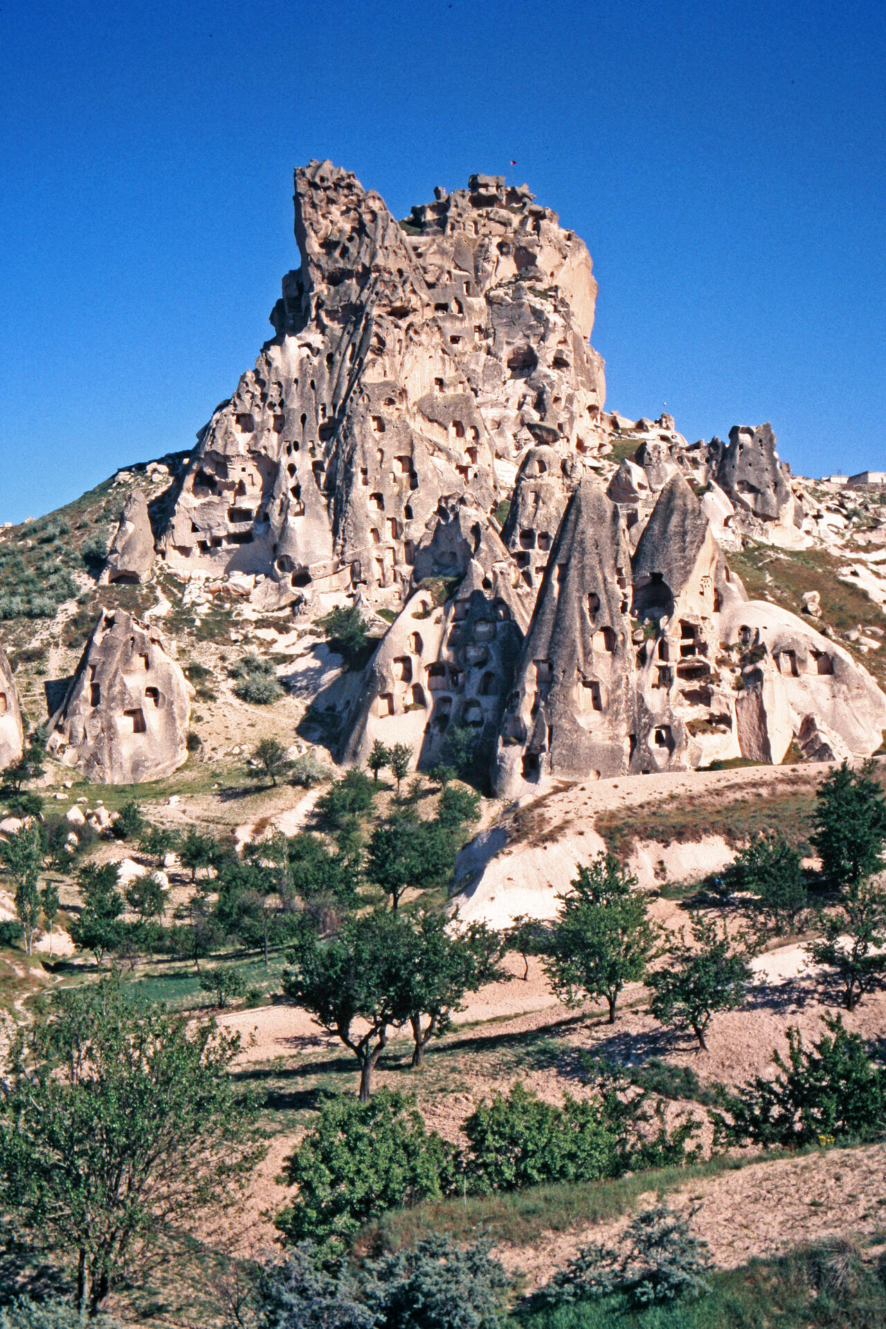
The park's most striking feature is its distinctive, water- and wind-sculpted landscape. The soft volcanic rock of the region has been eroded over millennia, resulting in a series of towering fairy chimneys, conical rock formations, and vast valleys. These geological wonders create a surreal, otherworldly atmosphere that draws visitors from around the globe.
Within this extraordinary landscape lie numerous churches and monastic complexes, providing a unique insight into Byzantine art, particularly from the post-Iconoclastic period. The richly decorated frescoes adorning these sanctuaries provide a vivid window into the religious beliefs and artistic traditions of the time. Among the most renowned examples is the Dark Church (Karanlık Kilise), celebrated for the remarkable preservation and intensity of its frescoes depicting biblical scenes.
In addition to its religious heritage, the Cappadocia region contains an extensive array of historical dwellings, troglodyte villages, and underground settlements carved directly into the rock. These subterranean complexes developed over many centuries, with origins possibly dating to earlier periods and significant expansion during the Byzantine era. They reflect the adaptive strategies of local communities in response to both environmental conditions and periods of insecurity.
One of the most notable examples is the Derinkuyu Underground City, which—together with Kaymaklı Underground City—forms part of the serial UNESCO World Heritage property of Göreme National Park and the Rock Sites of Cappadocia. This vast, multi-level complex extends several stories underground and could shelter thousands of people. Its labyrinthine corridors, storage chambers, stables, and churches illustrate how early Christian communities used these spaces as refuges during times of threat.
Beyond its historical and cultural significance, Göreme National Park and the Rock Sites of Cappadocia also boast outstanding natural beauty. Hot-air balloon flights offer panoramic views of the sculpted landscape at sunrise, while extensive hiking trails allow visitors to explore valleys, rock formations, and historic sites at ground level.
Altogether, Göreme National Park and the Rock Sites of Cappadocia stand as a powerful testament to the interaction between natural processes and human creativity. With its stunning landscapes, ancient churches, and subterranean settlements, the site offers an enduring and unforgettable record of life in central Anatolia.
UNESCO Description of the World Heritage Site
In a spectacular landscape, entirely sculpted by erosion, the Göreme valley and its surroundings contain rock-hewn sanctuaries that provide unique evidence of Byzantine art in the post-Iconoclastic period. Dwellings, troglodyte villages and underground towns – the remains of a traditional human habitat dating back to the 4th century – can also be seen there.
UNESCO Justification of the World Heritage Site
Criterion (i): Owing to their quality and density, the rupestral sanctuaries of Cappadocia constitute a unique artistic achievement offering irreplaceable testimony to the post-iconoclastic Byzantine art period.
Criterion (iii): The rupestral dwellings, villages, convents and churches retain the fossilized image of a province of the Byzantine Empire between the 4th century and the arrival of the Seljuk Turks (1071). Thus, they are the essential vestiges of a civilization which has disappeared.
Criterion (v): Cappadocia is an outstanding example of a traditional human settlement which has become vulnerable under the combined effects of natural erosion and, more recently, tourism.
Criterion (vii): In a spectacular landscape dramatically demonstrating erosional forces, the Göreme Valley and its surroundings provide a globally renowned and accessible display of hoodoo landforms and other erosional features, which are of great beauty, and which interact with the cultural elements of the landscape.
Encyclopedia Record: Göreme Historical National Park
Göreme Historical National Park is a national park in central Turkey. It occupies an area of nearly 100 km2 and is located in Nevşehir Province. It became a UNESCO World Heritage Site in 1985 under the name Göreme National Park and the Rock Sites of Cappadocia. The park features a rocky, water- and wind-eroded landscape with a network of ancient, interconnecting underground settlements.Additional Site Details
Area: 9,883.81 hectares
Number of Components: 7
(iii) — Unique or exceptional testimony to a cultural tradition
(v) — Outstanding example of traditional human settlement
(vii) — Contains superlative natural phenomena or beauty
Coordinates: 38.66667 , 34.85
IUCN World Heritage Outlook
The 2025 Conservation Outlook on Göreme National Park and the Rock Sites of Cappadocia reports the following assessment:
Source: International Union for Conservation of Nature (IUCN) · View assessment
Image
© W. Bulach, CC BY-SA 4.0 Resized from original. (This derivative is under the same CC BY-SA license.)
