World Heritage Identification Number: 377
World Heritage since: 1986
Category: Cultural Heritage
WHE Type: Buildings & Architectural Ensembles
Transboundary Heritage: No
Endangered Heritage: No
Country: 🇹🇷 Türkiye
Continent: Asia
UNESCO World Region: Europe and North America
Map
Hattusha: A Glimpse into the Ancient Hittite Civilization
The archaeological site of Hattusha, located near modern Boğazkale in Turkey, offers a captivating window into the ancient Hittite civilization that thrived in Anatolia and northern Syria during the second millennium BCE. Inscribed as a UNESCO World Heritage Site in 1986, Hattusha, formerly known as Ḫattuša, Hattusas, or Hattusha, served as the capital of the Hittite Empire during two distinct periods.
More to come…UNESCO Description of the World Heritage Site
The archaeological site of Hattusha, former capital of the Hittite Empire, is notable for its urban organization, the types of construction that have been preserved (temples, royal residences, fortifications), the rich ornamentation of the Lions' Gate and the Royal Gate, and the ensemble of rock art at Yazilikaya. The city enjoyed considerable influence in Anatolia and northern Syria in the 2nd millennium B.C.
UNESCO Justification of the World Heritage Site
Criterion (i): The city’s fortifications, along with the Lions’ Gate, the Royal Gate and the Yazılıkaya rupestral ensemble and its sculptured friezes, represent unique artistic achievements.
Criterion (ii): Hattusha exerted a dominating influence upon the civilizations of the 2nd and 1st millennia B.C. in Anatolia and northern Syria.
Criterion (iii): The palaces, temples, trading quarters and necropolis of this political and religious metropolis provide a comprehensive picture of a Hittite capital and bear a unique testimony to the now extinct Hittite civilization.
Criterion (iv): Several types of buildings or architectural ensembles are perfectly preserved in Hattusha: the royal residence, the temples and the fortifications.
Encyclopedia Record: Hattusa
Hattusa, also Hattuşa, Ḫattuša, Hattusas, or Hattusha, was the capital of the Hittite Empire in the late Bronze Age during two distinct periods. Its ruins lie near modern Boğazkale, Turkey, within the great loop of the Kızılırmak River.Additional Site Details
Area: 268.46 hectares
Number of Components: 4
(ii) — Significant interchange of human values
(iii) — Unique or exceptional testimony to a cultural tradition
(iv) — Outstanding example of a type of building or landscape
Coordinates: 40.01389 , 34.62056
Image
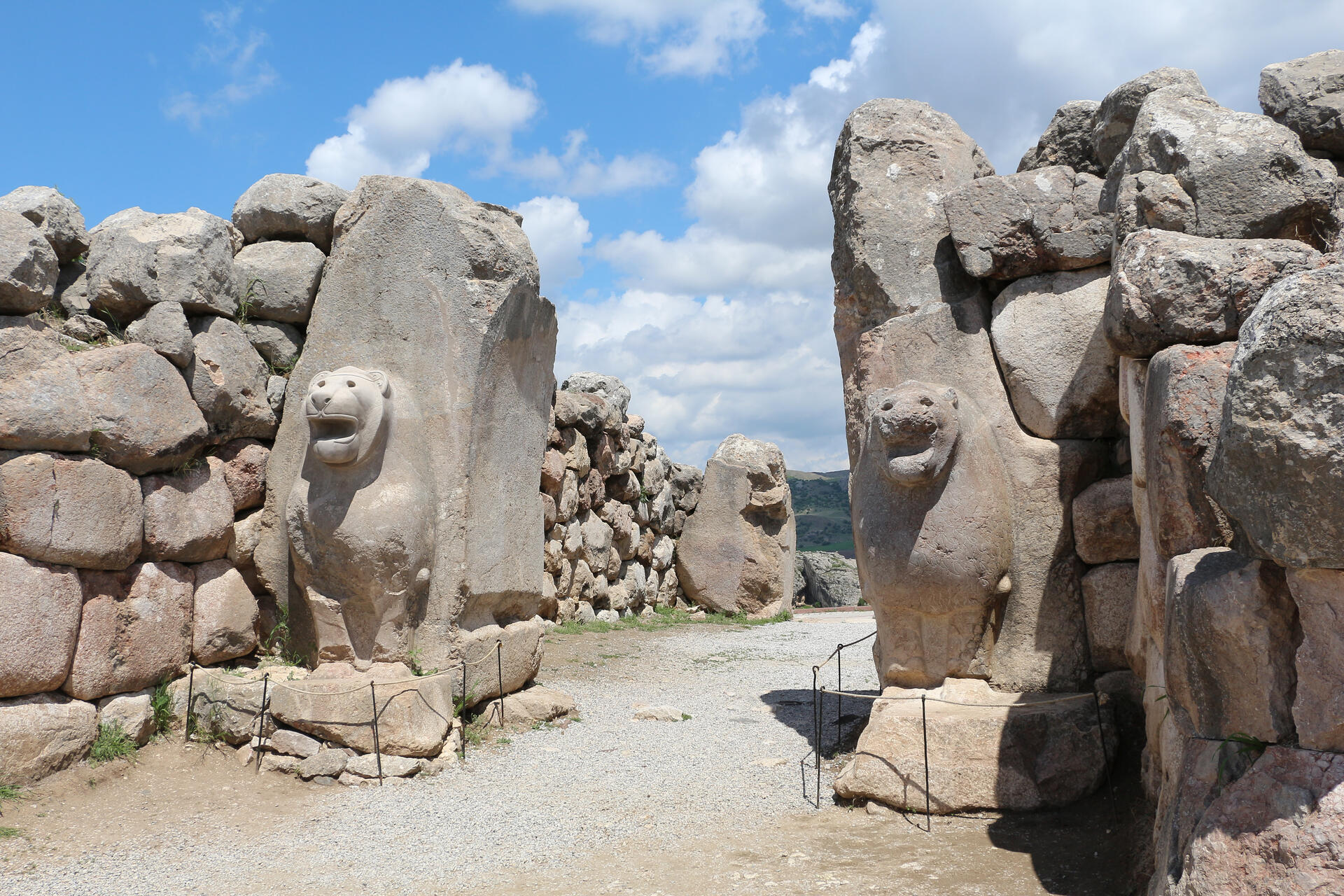
© Bernard Gagnon, CC BY-SA 3.0 Resized from original. (This derivative is under the same CC BY-SA license.)
World Heritage Research
Discover scientific research and academic studies that deepen our understanding of Hattusha: the Hittite Capital from its history and significance to its conservation, management, and contemporary challenges.
-
Anatolians during the Old Assyrian Period from the Etymological Perspective
A new etymological analysis of Old Assyrian cuneiform tablets from Anatolia reveals that the Hittite people were already deeply integrated into the region long before the rise of the Old Hittite Kingdom. Contrary to the traditional narrative, these findings indicate that the Hittites were not recent invaders but rather a sophisticated civilization with roots spanning hundreds or even a thousand years. The study suggests significant cultural and ethnic blending among Hittite, Luwian, Hurrian, and Hattian communities, highlighting Anatolia's complex pre-Hittite history. This challenges long-held assumptions about the origins of the Hittites and their political development.
Xiaowen, S. (2025). Anatolians during the Old Assyrian Period from the Etymological Perspective. Social Sciences in China, 46(1), 143–161. https://doi.org/10.1080/02529203.2025.2513824
View Publication Record | Read Publication -
Thebes versus Hattusha: two different ways of understanding time at the end of the Bronze Age
At the end of the Bronze Age, two ancient civilizations—the Hittite Empire centered at Hattusha and the Ramesside monarchy of Egypt—employed distinct time-keeping systems that reflected their climatic and sociological contexts. While Egypt's civil calendar aligned with seasonal rhythms after centuries of adaptation, evidence suggests the Hittites used a lunar-based system with potential intercalary months to synchronize with seasons, though its exact pattern remains unclear. This study contrasts these calendars, proposing that the Hittite system may have collapsed with the abandonment of Hattusha in the early 12th century BC, whereas Egypt's endured, evolving into the Julian and Gregorian calendars. The research synthesizes scarce Hittite data alongside Egyptian sources to highlight divergent approaches to time, offering insights into their cultural and environmental influences.
Belmonte Avilés, J. A. (2025). Thebes versus Hattusha: two different ways of understanding time at the end of the Bronze Age. Revista D Arqueologia de Ponent, (35), 101. https://doi.org/10.21001/rap.2025.35.6
View Publication Record | Read Publication -
Anitta Text
The Anitta text represents the earliest known example of Hittite propagandistic historiography, offering valuable insights into the political and cultural narratives of the Hittite Empire. This ancient text is written in cuneiform script, an adaptation of Mesopotamian writing, which the Hittites modified to suit their language. The discovery of over 30,000 cuneiform texts at Hattusha (modern-day Boğazkale) provides a rich corpus for studying Hittite and Akkadian languages, as well as international correspondence from the time. Additionally, the use of hieroglyphic script by Hittite monarchs to write Luwian dialects adds another layer to the linguistic and historical analysis of this period.
(Ed.). (2024). Anitta Text. Schlager Anthology of the Ancient World. https://doi.org/10.3735/9781961844193.book-part-013
View Publication Record | Read Publication -
Geochemical and petrographic approach for the origin of the limestone blocks of thewalls of the Great Temple of Hattusha, Çorum (N-Turkey)
A groundbreaking analysis of the limestone blocks used in the Great Temple at Hattusha, the ancient Hittite capital, reveals that these stones likely originated from five distinct sources. This conclusion is drawn from a comprehensive study combining petrographic and geochemical analyses, including stable isotopes (δ13C and δ18O) and trace element geochemistry, alongside Sr isotope ratios. The findings not only shed light on the construction techniques of this monumental structure but also provide valuable insights into the Hittites' acquisition and utilization of building materials during their civilization.
YILMAZ, İ. Ö., SCHACHNER, A., UYSAL, İ. T., & İMER, E. Ü. (2022). Geochemical and petrographic approach for the origin of the limestone blocks of thewalls of the Great Temple of Hattusha, Çorum (N-Turkey). Turkish Journal of Earth Sciences, 31(3), 294–304. https://doi.org/10.55730/1300-0985.1774
View Publication Record | Read Publication -
The agroecology of an early state: new results from Hattusha
A remarkable archaeological discovery at Hattusha, the Late Bronze Age capital of the Hittite Empire, reveals a vast underground silo complex containing intact grain stores. This finding offers an unprecedented glimpse into how the Hittite state mobilized crop production through extensive, low-input cultivation strategies, primarily focusing on hulled wheats and barley. By combining archaeobotanical analysis with stable isotope determinations and functional weed ecology, researchers have uncovered new insights into Hittite agricultural practices and their political implications. The study highlights how taxation of extensively produced grain in the 16th century BCE sustained this ancient state, providing broader implications for understanding the politics and ecology of expansive territorial states in Western Asia.
Diffey, C., Neef, R., Seeher, J., & Bogaard, A. (2020). The agroecology of an early state: new results from Hattusha. Antiquity, 94(377), 1204–1223. https://doi.org/10.15184/aqy.2020.172
View Publication Record | Read Publication -
Hittite Empire
Hattusha, the capital of the Hittite Empire, stands as one of the most significant archaeological sites in the Ancient Near East. Excavations at the site have uncovered thousands of clay tablets inscribed with cuneiform texts, offering unprecedented insights into the history and culture of Anatolia and its neighboring regions during the second millennium BCE. These records reveal the Hittites' transition from a regional kingdom to an interregional empire, showcasing their political influence and cultural significance in the pre-classic world. Despite their eventual decline at the end of the Bronze Age, the Hittite Empire remains a pivotal subject for understanding ancient Indo-European civilizations.
Giusfredi, F. (2016). Hittite Empire. The Encyclopedia of Empire, 1–7. Portico. https://doi.org/10.1002/9781118455074.wbeoe265
View Publication Record | Read Publication -
The Pillars of the Earth and the Sky
Ancient cities were strategically designed to align with cosmic order, particularly the sun's solstitial movements. A comparative study of four 'solstitial' cities—Thebes (Egypt), Hattusha (Hittite Empire), Carthago Nova (Carthaginian dominions in Iberia), and Petra (Nabataean Kingdom)—reveals a shared pattern: their geographical positions, orography, and monumental orientations were deliberately linked to solar benchmarks. This suggests that Mediterranean societies with strong solar cults or symbolism employed similar urban planning principles, connecting sacred spaces with solstitial orientations. The research uses archaeoastronomy to analyze how these cities integrated astronomical observations into their layouts, offering insights into the religious and cultural significance of solar hierophanies in ancient urban development.
Belmonte, J. A., & González-García, A. C. (2015). The Pillars of the Earth and the Sky. Journal of Skyscape Archaeology, 1(1), 9–38. https://doi.org/10.1558/jsa.v1i1.26952
View Publication Record | Read Publication