World Heritage Identification Number: 277
World Heritage since: 1985
Category: Cultural Heritage
WHE Type: Archaeological Sites
Transboundary Heritage: No
Endangered Heritage: Yes
Country: 🇮🇶 Iraq
Continent: Asia
UNESCO World Region: Arab States
Map
Hatra: An Ancient City of the Parthian Empire
Hatra, officially recognized as a UNESCO World Heritage Site since 1985, is an essential archaeological site that offers insights into the rich history and culture of the Parthian Empire. Situated in present-day eastern Nineveh Governorate in northern Iraq, approximately 290 kilometers (180 miles) northwest of Baghdad and 110 kilometers (68 miles) southwest of Mosul, Hatra stands as one of the most significant archaeological sites from this ancient empire known to date.
More to come…UNESCO Description of the World Heritage Site
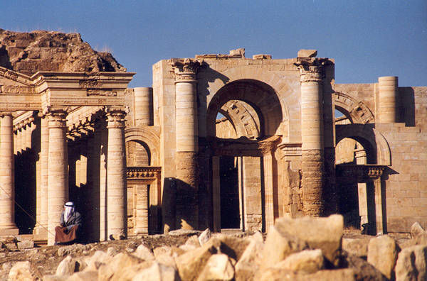
A large fortified city under the influence of the Parthian Empire and capital of the first Arab Kingdom, Hatra withstood invasions by the Romans in A.D. 116 and 198 thanks to its high, thick walls reinforced by towers. The remains of the city, especially the temples where Hellenistic and Roman architecture blend with Eastern decorative features, attest to the greatness of its civilization.
UNESCO Justification of the World Heritage Site
Criterion (ii): The great Iwans of the Hatra temenos, remarkable for the perfection of their vaulted chambers, and the fourteen small temples scattered outside the sacred enclosure, have exerted lasting influence over the region's architecture up until the Islamic age.
Criterion (iii): By virtue of its monuments and inscriptions, Hatra offers exceptional testimony to an entire facet of AssyroBabylonian civilization subjected to the influence of Greeks, Parthians, Romans and Arabs. It is the best-preserved city of the Parthian empire (ca. 200 BC-220 AD).
Criterion (iv): Hatra is an excellent example of fortified cities along the circular plan of the East, such as Ctesiphon, Firouzabad or Zingirli. The perfect condition of the double wall in an untouched environment sets it aside as an outstanding example of a series which covers the Parthian, Sassanid and ancient Islamic civilizations.
Criterion (vi): The city success against Roman forces, led to it being considered an outstanding symbol of Parthian power.
Encyclopedia Record: Hatra
Hatra was an ancient Arab city in Upper Mesopotamia located in present-day eastern Nineveh Governorate in northern Iraq. The ruins of the city lie 290 km (180 mi) northwest of Baghdad and 110 km (68 mi) southwest of Mosul. It is considered the richest archaeological site from the Parthian Empire known to date.Additional Site Details
Area: 323.75 hectares
Number of Components: 1
(iii) — Unique or exceptional testimony to a cultural tradition
(iv) — Outstanding example of a type of building or landscape
(vi) — Directly associated with events or living traditions
Coordinates: 35.58806 , 42.71833
IUCN World Heritage Outlook
The 2025 Conservation Outlook on K’gari reports the following assessment:
Source: International Union for Conservation of Nature (IUCN) · View assessment