World Heritage Identification Number: 276
World Heritage since: 2007
Category: Cultural Heritage
WHE Type: Archaeological Sites
Transboundary Heritage: No
Endangered Heritage: Yes
Country: 🇮🇶 Iraq
Continent: Asia
UNESCO World Region: Arab States
Map
Samarra Archaeological City: A Testament to the Architectural and Artistic Innovations of the Abbasid Empire
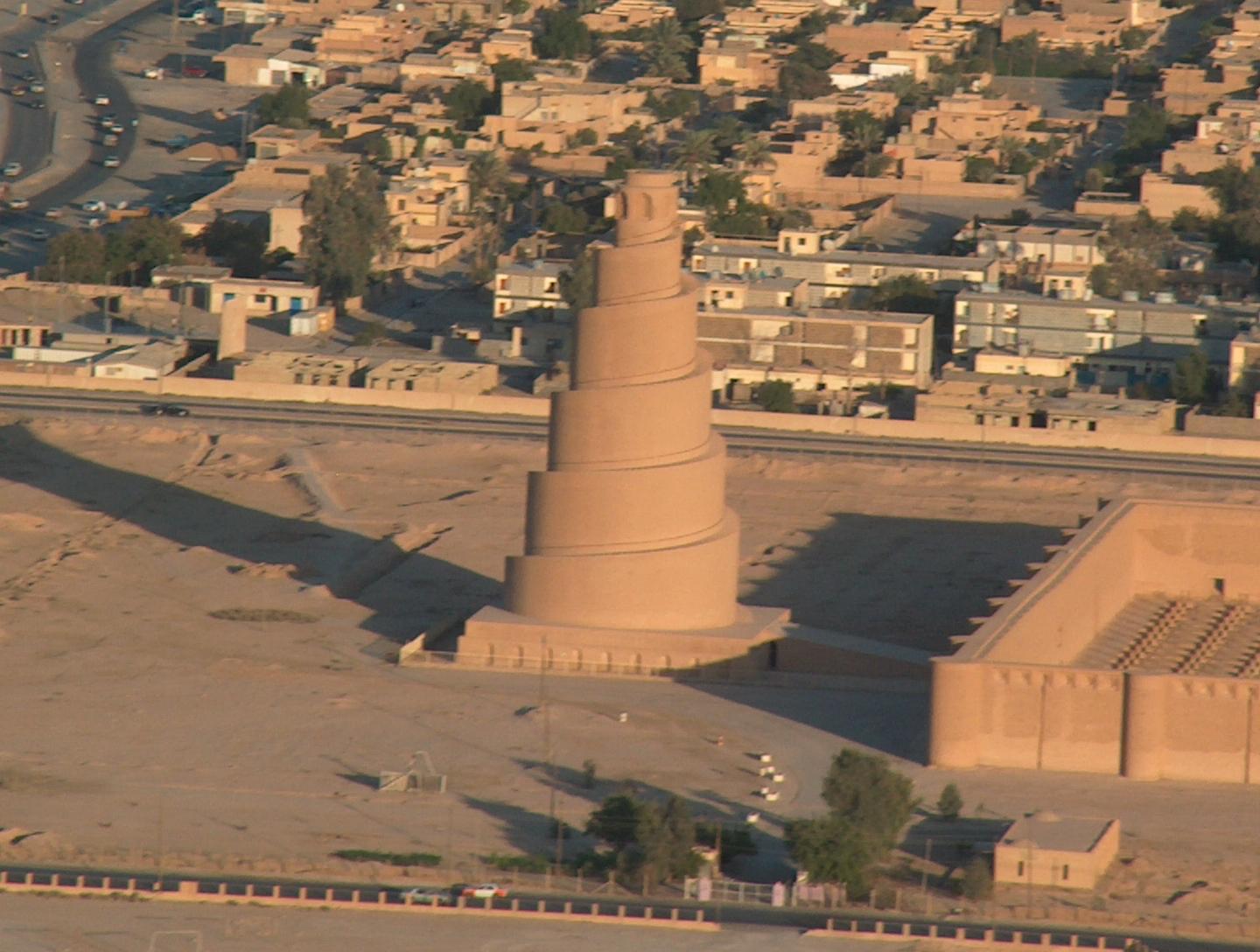
The Samarra Archaeological City, inscribed as a UNESCO World Heritage Site in 2007, offers a unique glimpse into the architectural and artistic achievements of the Abbasid Empire during the 9th century. Situated along the banks of the River Tigris, approximately 130 kilometers north of Baghdad, this expansive site stretches over 41.5 kilometers from north to south, with its width varying between 8 to 4 kilometers.
More to come…UNESCO Description of the World Heritage Site
Samarra Archaeological City is the site of a powerful Islamic capital city that ruled over the provinces of the Abbasid Empire extending from Tunisia to Central Asia for a century. Located on both sides of the River Tigris 130 km north of Baghdad, the length of the site from north to south is 41.5 km; its width varying from 8 km to 4 km. It testifies to the architectural and artistic innovations that developed there and spread to the other regions of the Islamic world and beyond. The 9th-century Great Mosque and its spiral minaret are among the numerous remarkable architectural monuments of the site, 80% of which remain to be excavated.
UNESCO Justification of the World Heritage Site
Criterion (ii): Samarra represents a distinguished architectural stage in the Abbasid period by virtue of its mosques, its development, the planning of its streets and basins, its architectural decoration, and its ceramic industries.
Criterion (iii): Samarra is the finest preserved example of the architecture and city planning of the Abbasid Caliphate, extending from Tunisia to Central Asia, and one of the world's great powers of that period. The physical remains of this empire are usually poorly preserved since they are frequently built of unfired brick and reusable bricks.
Criterion (iv): The buildings of Samarra represent a new artistic concept in Islamic architecture in the Malwiya and Abu Dulaf mosques, in the form of a unique example in the planning, capacity and construction of Islamic mosques by comparison with those which preceded and succeeded it. In their large dimensions and unique minarets, these mosques demonstrate the pride and political and religious strength that correspond with the strength and pride of the empire at that time.
Encyclopedia Record: Samarra
Samarra is a city in Iraq. It stands on the east bank of the Tigris in the Saladin Governorate, 125 kilometers (78 mi) north of Baghdad. The modern city of Samarra was founded in 836 by the Abbasid caliph al-Mu'tasim as a new administrative capital and military base. In 2003 the city had an estimated population of 348,700. During the Iraqi Civil War (2006–08), Samarra was in the "Sunni Triangle" of resistance.Additional Site Details
Area: 15,058 hectares
Number of Components: 10
(iii) — Unique or exceptional testimony to a cultural tradition
(iv) — Outstanding example of a type of building or landscape
Coordinates: 34.3409894444 , 43.8235430555