World Heritage Identification Number: 1031
World Heritage since: 2001
Category: Cultural Heritage
WHE Type: Historic Cities & Urban Areas
Transboundary Heritage: No
Endangered Heritage: No
Country: 🇵🇹 Portugal
Continent: Europe
UNESCO World Region: Europe and North America
Map
A Journey Through Time: The Historic Centre of Guimarães and Couros Zone
The Historic Centre of Guimarães and Couros Zone, located in the heart of Portugal, offers a unique glimpse into the country's rich history and cultural evolution. Inscribed as a UNESCO World Heritage Site in 2001, this urban space stands as a testament to over a thousand years of Portuguese urban, architectural, and societal development.
More to come…UNESCO Description of the World Heritage Site
The historic town of Guimarães is associated with the emergence of the Portuguese national identity in the 12th century. An exceptionally well-preserved and authentic example of the evolution of a medieval settlement into a modern town, its rich building typology exemplifies the specific development of Portuguese architecture from the 15th to 19th century through the consistent use of traditional building materials and techniques. The property includes two monastic complexes and an industrial area, the Couros Zone, which, like the local river, was named after the traditional craft of leather tanning. Evidence of the craft, though no longer practiced, persists in the form of tanneries, workers' houses and urban spaces from the 19th and early 20th centuries. The property bears witness to a thousand years of Portuguese urban, architectural and societal developments.
UNESCO Justification of the World Heritage Site
Criterion (ii): Guimarães, with its proto-industrial Couros Zone, is of considerable universal significance due to the fact that specialised building techniques developed there in the Middle Ages were transmitted to Portuguese colonies in Africa and the New World, becoming a characteristic feature.
Criterion (iii): The early history of Guimarães is closely associated with the establishment of Portuguese national identity and language in the 12th century. The Couros Zone bears witness to the wealth that independence brought to Guimarães and that made possible its continuous and harmonious urban and architectural development until the end of the 19th century.
Criterion (iv): The Historic Centre of Guimarães and Couros Zone is an exceptionally well-preserved town that illustrates the evolution of particular building types from the medieval settlement to the present-day city, and particularly in the 15th–19th centuries.
Encyclopedia Record: Historic Centre of Guimarães
Historic Centre of Guimarães is an urban space of the city of Guimarães, in Portugal, tracing back to medieval age covering an area of 16 hectares and retaining many buildings from the medieval age until 19th century. Since 2001, it is declared as a World Heritage Site of UNESCO.Additional Site Details
Area: 38.2 hectares
Number of Components: 1
(iii) — Unique or exceptional testimony to a cultural tradition
(iv) — Outstanding example of a type of building or landscape
Coordinates: 41.443 , -8.2927777778
Image
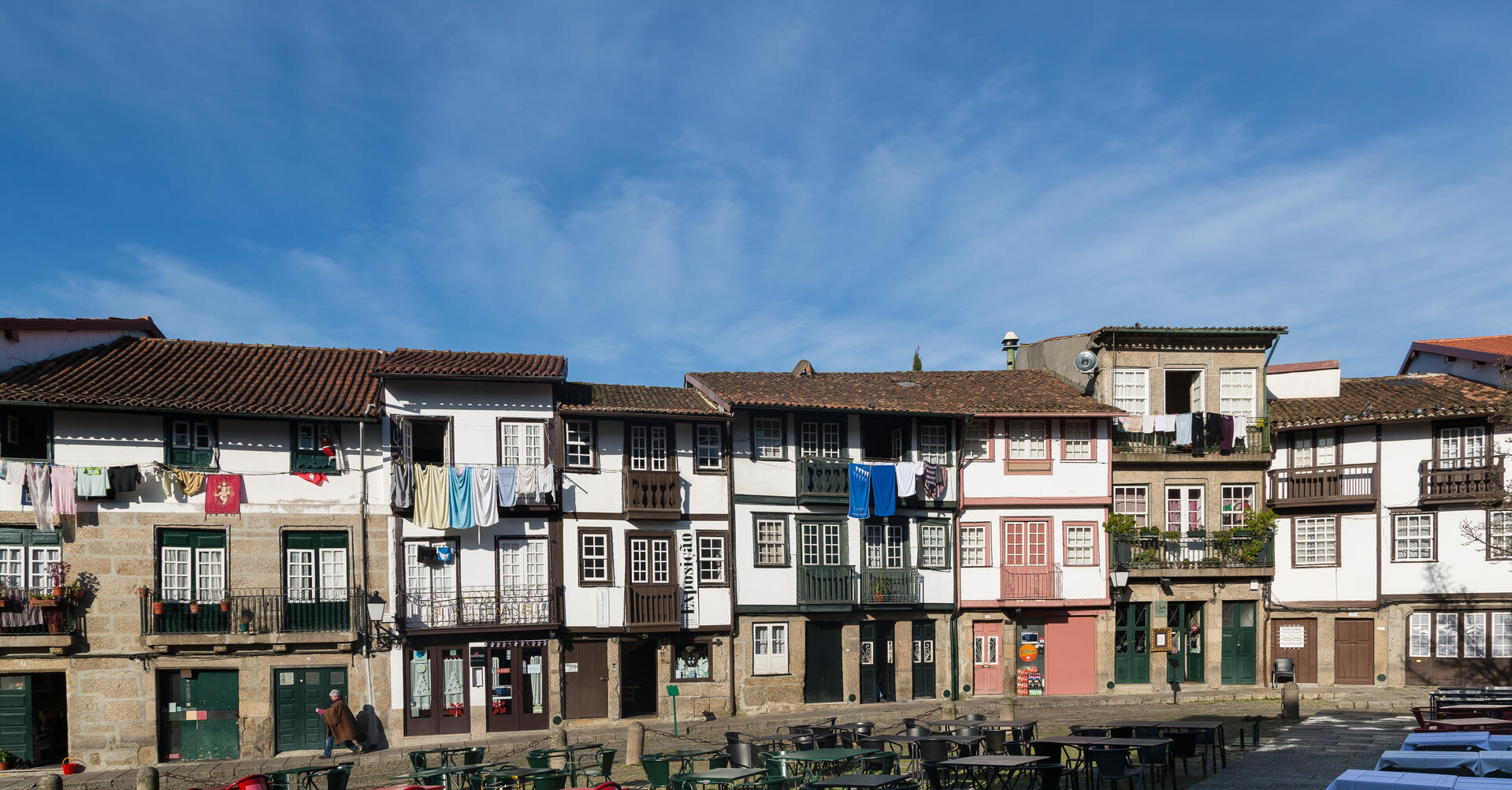
© CEphoto, Uwe Aranas, CC BY-SA 3.0 Resized from original. (This derivative is under the same CC BY-SA license.)
World Heritage Research
Discover scientific research and academic studies that deepen our understanding of Historic Centre of Guimarães and Couros Zone from its history and significance to its conservation, management, and contemporary challenges.
-
Understanding and Managing Risk in Historic Areas: A Multi-hazard Vulnerability Assessment of the Historic City Centre of Guimarães, Portugal
A multi-hazard vulnerability assessment of the Historic Centre of Guimarães, Portugal, reveals critical insights into the city's exposure to flood and fire risks. The study identifies key indicators of sensitivity and exposure, providing a foundation for cost-efficient risk reduction strategies tailored to historic urban areas. By analyzing on-site data collected over different periods using two index-based methodologies, researchers mapped vulnerability outputs via GIS tools, enhancing readability and analysis. This approach offers practical guidance for managing threats in culturally significant yet vulnerable regions.
Baquedano-Juliá, P., Navia Miranda, F., Graus, S., & Ferreira, T. M. (2025). Understanding and Managing Risk in Historic Areas: A Multi-hazard Vulnerability Assessment of the Historic City Centre of Guimarães, Portugal. 3D Research Challenges in Cultural Heritage IV, 46–57. https://doi.org/10.1007/978-3-031-93753-8_3
View Publication Record | Read Publication -
An Integrated Approach for Assessing Flood Risk in Historic City Centres
A new methodology for assessing flood risk in historic city centres, tested on the UNESCO-listed Historic Centre of Guimarães (Portugal), reveals that combining hazard and physical vulnerability data can identify high-risk buildings otherwise overlooked by traditional risk assessments. The study used hydrologic–hydraulic modelling to simulate a 100-year flood scenario, deriving hazard scores from flood extent, depth, and velocity. Vulnerability was evaluated based on field-collected data such as building orientation, heritage status, age, material, and condition. By integrating these components into a risk-matrix, the research demonstrated that both individual and crossed analyses provide complementary insights—highlighting critical risk factors while also uncovering previously unnoticed high-risk structures. This approach offers a more nuanced understanding of flood risk in vulnerable urban areas.
Ferreira, T. M., & Santos, P. P. (2020). An Integrated Approach for Assessing Flood Risk in Historic City Centres. Water, 12(6), 1648. https://doi.org/10.3390/w12061648
View Publication Record | Read Publication -
Municipal Waste Map: a Case Study of Guimarães, Portugal
A comprehensive Municipal Waste Map for Guimarães, Portugal—a UNESCO World Heritage Site and candidate for European Green Capital 2020—reveals critical insights into waste production patterns shaped by urban density, land use, and socio-demographic factors. The study highlights that one-third of the population resides in the urban core, significantly influencing waste management challenges. By integrating multi-disciplinary data on land use, citizen demographics, and human resources, researchers have mapped waste generation across a 'diffuse territory,' where varied economic activities create distinct scenarios. This approach supports the development of a Strategic Waste Plan (2016–2025), aligning with Guimarães' sustainability goals, including its bid for European Green Capital status.
(Ed.). (2015). Municipal Waste Map: a Case Study of Guimarães, Portugal. European Journal of Sustainable Development, 5(3). https://doi.org/10.14207/ejsd.2016.v5n3p77
View Publication Record | Read Publication