World Heritage Identification Number: 1170
World Heritage since: 2005
Category: Cultural Heritage
WHE Type: Historic Cities & Urban Areas
Transboundary Heritage: No
Endangered Heritage: No
Country: 🇷🇺 Russian Federation
Continent: Europe
UNESCO World Region: Europe and North America
Map
A Journey Through Time: Exploring the Historical Centre of the City of Yaroslavl
The Historical Centre of the City of Yaroslavl, nestled at the confluence of the Volga and Kotorosl Rivers, offers a captivating journey through Russia's rich historical tapestry. Inscribed as a UNESCO World Heritage Site in 2005, this ancient city boasts a fascinating blend of architectural styles, spanning from the 12th century to the neoclassical era.
More to come…UNESCO Description of the World Heritage Site
Situated at the confluence of the Volga and Kotorosl Rivers some 250 km north-east of Moscow, the historic city of Yaroslavl developed into a major commercial centre from the 11th century. It is renowned for its numerous 17th-century churches and is an outstanding example of the urban planning reform Empress Catherine the Great ordered for the whole of Russia in 1763. While keeping some of its significant historic structures, the town was renovated in the neoclassical style on a radial urban master plan. It has also kept elements from the 16th century in the Spassky Monastery, one of the oldest in the Upper Volga region, built on the site of a pagan temple in the late 12th century but reconstructed over time.
UNESCO Justification of the World Heritage Site
Criterion (ii): Historical Centre of the City of Yaroslavl with its 17th-century churches and its neoclassical radial urban plan and civic architecture is an outstanding example of the interchange of cultural and architectural influences between Western Europe and the Russian Empire.
Criterion (iv): Historical Centre of the City of Yaroslavl is an outstanding example of the town-planning reform ordered by Empress Catherine The Great in the whole of Russia, implemented between 1763 and 1830.
Encyclopedia Record: Yaroslavl
Yaroslavl is a city and the administrative center of Yaroslavl Oblast, Russia, located 250 kilometers (160 mi) northeast of Moscow. The historic part of the city is a World Heritage Site, and is located at the confluence of the Volga and the Kotorosl rivers. It is part of the Golden Ring, a group of historic cities northeast of Moscow that have played an important role in Russian history. The population of the city at the 2021 census was 577,279.Additional Site Details
Area: 110 hectares
Number of Components: 1
(iv) — Outstanding example of a type of building or landscape
Coordinates: 57.65278 , 39.87611
Image
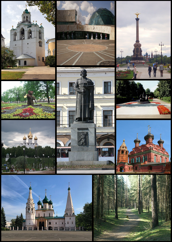
© User:Veinarde, User:Gnesener1900, User:PetarM, User:Monedula, User:Jochims, User:Alexxx1979, User:Nastyusha, User:Night Rain 5, CC BY 3.0 Resized from original.
World Heritage Research
Discover scientific research and academic studies that deepen our understanding of Historical Centre of the City of Yaroslavl from its history and significance to its conservation, management, and contemporary challenges.
-
Trajectories and problems of the current spatial development of Russia’s European Near North regions
A multiscale approach reveals significant socioeconomic contrasts within Russia's European Near North region, highlighting the complex interplay between urban centers and peripheral areas. The study identifies pronounced trends of developed area compression and degraded living conditions post-Soviet era, alongside shifts in agricultural land use towards animal husbandry. Analyzing population changes (1990–2022), migration patterns, employment dynamics, and infrastructure development, it underscores the growing patchwork nature of farming and the varying impact of regional centers on surrounding territories. These findings provide critical insights for refining national and regional spatial development strategies.
Nefedova, T. G. (2024). Trajectories and problems of the current spatial development of Russia’s European Near North regions. Baltic Region, 16(3), 42–61. https://doi.org/10.5922/2079-8555-2024-3-3
View Publication Record | Read Publication -
“On the way to the “green agenda”?”: discourse of regional authorities on the improvement of Yaroslavl in the historical context of interaction with the centre (the 1960s–1980s)
Regional leadership significantly influenced urban improvement strategies in Yaroslavl during the Soviet era (1960s–1980s), despite central government dominance. The study reveals that while federal policies shaped long-term development, local leaders played a pivotal role in tactical decisions, particularly regarding public transport and green spaces. Analyzing archival documents, memoirs, journalism, and oral histories—including unpublished records from the Yaroslavl Region Documentation Centre—the research highlights tensions between municipal and regional authorities over tram line expansion. This dual-level governance dynamic underscores how environmental trends emerged within a centralized yet locally adaptive framework, offering insights into the historical roots of urban sustainability efforts.
Nikiforov, Y. S. (2022). “On the way to the “green agenda”?”: discourse of regional authorities on the improvement of Yaroslavl in the historical context of interaction with the centre (the 1960s–1980s). Vestnik of Kostroma State University, 28(1), 63–69. https://doi.org/10.34216/1998-0817-2022-28-1-63-69
View Publication Record | Read Publication -
Space of power: historical addresses of the Yaroslavl District Court (1866-1917)
The Yaroslavl District Court, established in 1866 as part of the judicial reform of that year, symbolized power through its architectural representation. Initially housed in a classical-style building on Andropov Street, it later moved to the prestigious Government House on Ilyinskaya Square—a landmark from the 'golden decade' of Melgunovskaya. This study traces the court's historical addresses and their significance within Yaroslavl’s administrative landscape, noting its proximity to other provincial institutions. The research underscores the need for restoring the northern corps of the Government House, a UNESCO-listed site, as part of Yaroslavl’s cultural heritage, especially with plans to relocate the regional court there.
Marasanova, V. M. (2022). Space of power: historical addresses of the Yaroslavl District Court (1866-1917). Yaroslavl Pedagogical Bulletin, 1(124), 216–224. https://doi.org/10.20323/1813-145x-2022-1-124-216-224
View Publication Record | Read Publication -
The influence of Moscow and Leningrad on the compositional organization of residential quarters in Yaroslavl in the 1920s and 1930s
Residential development in Yaroslavl during the 1920s and 1930s reflected distinct stages influenced by Moscow's mechanistic urban planning and Leningrad's emphasis on preserving historical heritage. The study identifies a shift from a focus on filling vacant land to a more controlled approach that integrated central urban spaces, ultimately prioritizing the conservation of valuable historical elements within neighborhoods. By comparing Yaroslavl's architectural practices with those of Moscow and Leningrad, researchers uncovered unique compositional techniques applied both in new developments and in areas with significant historical legacy.
Vasileva, A. V. (2020). The influence of Moscow and Leningrad on the compositional organization of residential quarters in Yaroslavl in the 1920s and 1930s. Vestnik MGSU, (11), 1493–1504. https://doi.org/10.22227/1997-0935.2020.11.1493-1504
View Publication Record | Read Publication -
The Historic City Centre of Yaroslavl in the Pre-Mongolian Period According to Archaeological Data
Archaeological research in Yaroslavl, Russia, reveals that the city's historic center dates back to the pre-Mongolian period (10th–13th centuries), challenging earlier assumptions about its origins. The study identifies a fortified wooden city (rubleny gorod) with evidence of urban planning, suggesting organized settlement and early state formation in this region. Using stratigraphic analysis, artifact dating, and comparative methods, researchers reconstructed the city's layout, including defensive structures like palisades and gates, as well as residential and administrative areas. These findings provide new insights into the development of medieval Rus' cities before Mongol invasions, contributing to a deeper understanding of Yaroslavl's historical significance.
Энговатова, А.В. (2020). THE HISTORIC CITY CENTRE OF YAROSLAVL IN THE PRE-MONGOLIAN PERIOD ACCORDING TO ARCHAEOLOGICAL DATA. Древняя Русь. Вопросы Медиевистики, (4(78)). https://doi.org/10.25986/iri.2019.78.4.008
View Publication Record | Read Publication -
The Regional Aspect of the Study of the Transformation of Russian Society in the 1950-1990s and the Evolution of the Economic System: Representativeness and Uniqueness of the Upper Volga Regions of the Late USSR
The Upper Volga region, encompassing Vladimir, Ivanovo, Kostroma, Kalinin (Tver), and Yaroslavl, emerges as both representative of the late Soviet era's socio-economic transformations and uniquely distinct in its cultural and geographical significance. This study highlights the region's dual role: as a microcosm reflecting broader Soviet political and economic dynamics while possessing unique characteristics shaped by its industrial prominence, scientific-technical contributions, and proximity to Moscow. The research employs theoretical frameworks from Mikhail Beznin, Tat’yana Dimoni, Alexei Yurchak, and others to analyze the region's evolution during the 1950-1990s, emphasizing its significance in the military-industrial complex, elite formation, and cultural identity as part of Russia's 'Golden Ring.' The study underscores the need for a dual analytical approach—balancing representativeness with regional uniqueness—to fully understand the complexities of Soviet societal transformation.
Nikiforov, Y. S. (2020). THE REGIONAL ASPECT OF THE STUDY OF THE TRANSFORMATION OF RUSSIAN SOCIETY IN THE 1950-1990S AND THE EVOLUTION OF THE ECONOMIC SYSTEM: REPRESENTATIVENESS AND UNIQUENESS OF THE UPPER VOLGA REGIONS OF THE LATE USSR. Vestnik of Kostroma State University, (2), 52–60. https://doi.org/10.34216/1998-0817-2020-26-2-52-60
View Publication Record | Read Publication -
Rf Postsoviet Urbanonymy: Main Nomination Motives and Citizens’ Expectations
This study identifies three primary motives behind postsoviet urbanonymy: memorial (commemorative), descriptive, and evsemantic (positive). Memorial names dominate, often honoring saints, prerevolutionary heroes, local figures, or those who perished in service. The research highlights the need for careful creation of descriptive and evsemantic names to reflect regional identity accurately, such as naming streets after natural phenomena or endangered species. It emphasizes the importance of developing a regional urbanonymy policy involving historians, culturologists, philologists, and ethnographers to guide toponymic committees and align with societal expectations.
Razumov, R. V. (2020). RF POSTSOVIET URBANONYMY: MAIN NOMINATION MOTIVES AND CITIZENS’ EXPECTATIONS. Verhnevolzhski Philological Bulletin, 22(3), 90–98. https://doi.org/10.20323/2499-9679-2020-3-22-89-97
View Publication Record | Read Publication