World Heritage Identification Number: 966
World Heritage since: 2000
Category: Natural Heritage
WHE Type: Protected Areas & National Parks
Transboundary Heritage: No
Endangered Heritage: No
Country: 🇦🇷 Argentina
Continent: Americas
UNESCO World Region: Latin America and the Caribbean
Map
The Fossil-Rich Landscape of Ischigualasto / Talampaya Natural Parks
The Ischigualasto / Talampaya Natural Parks, located in the arid region bordering the Sierra Pampeanas of central Argentina, offer a unique glimpse into Earth's ancient history. Inscribed as a UNESCO World Heritage Site in 2000, these two adjacent parks span over 275,300 hectares, with Ischigualasto Provincial Park occupying 60,370 hectares alone.
More to come…UNESCO Description of the World Heritage Site
These two contiguous parks, extending over 275,300 ha in the desert region on the western border of the Sierra Pampeanas of central Argentina, contain the most complete continental fossil record known from the Triassic Period (245-208 million years ago). Six geological formations in the parks contain fossils of a wide range of ancestors of mammals, dinosaurs and plants revealing the evolution of vertebrates and the nature of palaeo-environments in the Triassic Period.
UNESCO Justification of the World Heritage Site
Criterion (viii): The property of Ischigualasto-Talampaya Natural Parks is of extraordinary scientific importance, providing a complete sequence of fossiliferous continental sediments representing the Triassic Period of geological history (c.250-200 million years before present), and revealing the evolution of vertebrate life and the nature of palaeoenvironments in the Triassic that ushered in the “Age of the Dinosaurs”.Extending over the Ischigualasto-Villa Unión sedimentary basin, , the dramatic natural landscape of the property exposes six geological formations that clearly and exceptionally document the major stage of Earth’s history from the evolution from the mammal ancestors in the Early Triassic to the rise of dinosaur dominance during the Triassic. The rich diversity of fossils includes some 56 known genera and many more species of vertebrates, including but not limited to fish, amphibians and a great variety of reptiles and direct mammalian ancestors, including the early dinosaur: Eoraptor, and at least 100 species of plants together with abundant emphasis of the environments of the time. Together these remains provide a unique window on life in the Triassic Period, with many new discoveries still to be made.
Encyclopedia Record: Ischigualasto Provincial Park
Ischigualasto Provincial Park, also called Valle de la Luna, due to its moon-like appearance, is a provincial protected area in the north-east of San Juan Province, north-western Argentina, limiting to the north with the Talampaya National Park, in La Rioja Province. Both areas belong to the same geological formation, the Ischigualasto Formation . Established on 3 November 1971, the park has an area of 60,370 ha.Additional Site Details
Area: 275,369 hectares
Number of Components: 1
Coordinates: -30 , -68
IUCN World Heritage Outlook
The 2025 Conservation Outlook on Ischigualasto / Talampaya Natural Parks reports the following assessment:
Source: International Union for Conservation of Nature (IUCN) · View assessment
Image
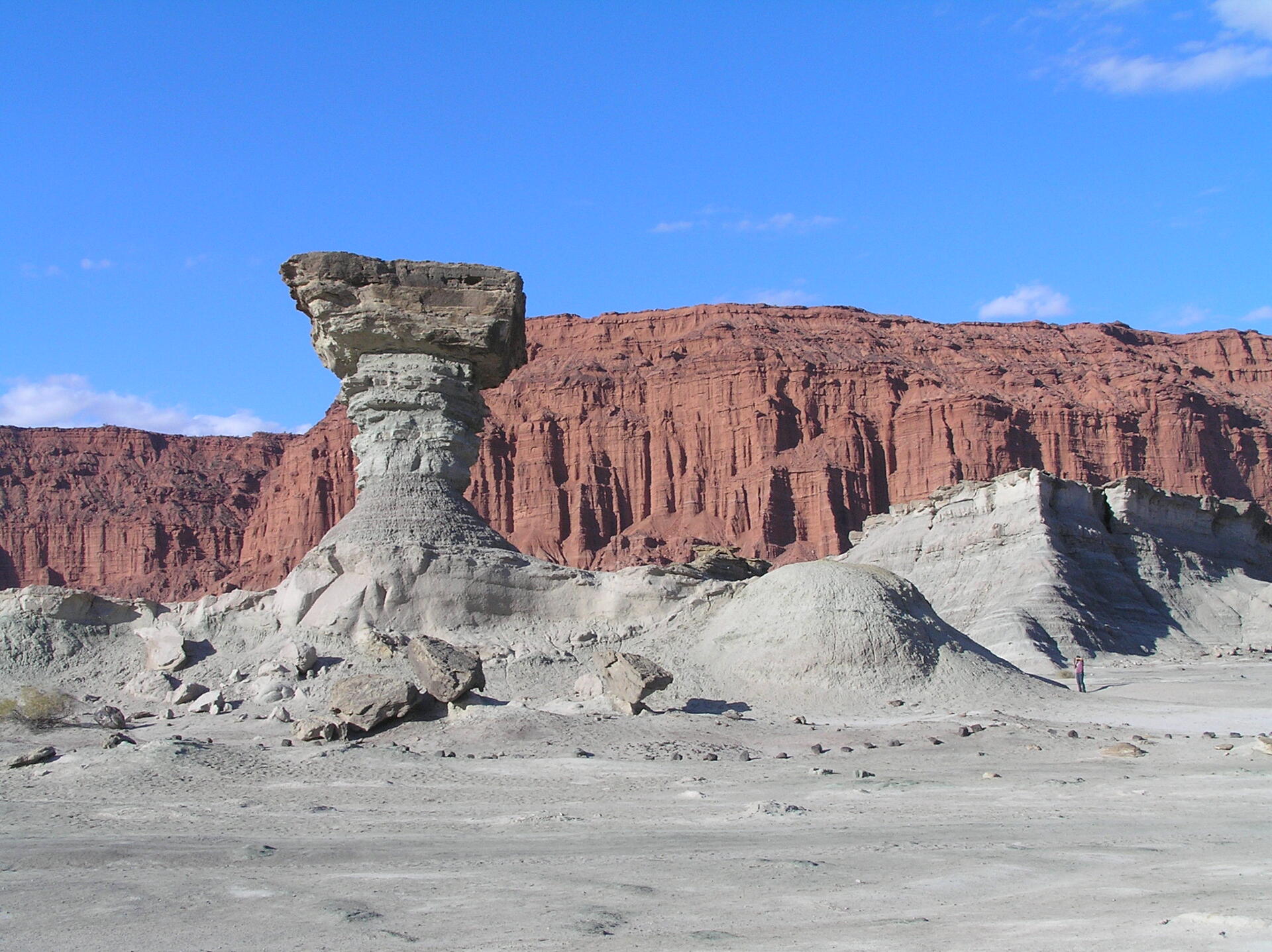
© M.Bustos, CC BY-SA 4.0 Resized from original. (This derivative is under the same CC BY-SA license.)
