World Heritage Identification Number: 1182
World Heritage since: 2005
Category: Natural Heritage
WHE Type: Protected Areas & National Parks
Transboundary Heritage: No
Endangered Heritage: Yes
Country: 🇲🇽 Mexico
Continent: Americas
UNESCO World Region: Latin America and the Caribbean
Map
The Islands and Protected Areas of the Gulf of California: A Natural Laboratory for Marine Biodiversity
The Islands and Protected Areas of the Gulf of California, inscribed as a UNESCO World Heritage Site in 2005, is a remarkable collection of 244 islands, islets, and coastal areas situated within the Gulf of California in north-eastern Mexico. This region, often referred to as the Sea of Cortez or the Sea of Cortés, has been recognized for its significant role in oceanography and biology, earning the moniker "a natural laboratory for the investigation of speciation."
More to come…UNESCO Description of the World Heritage Site
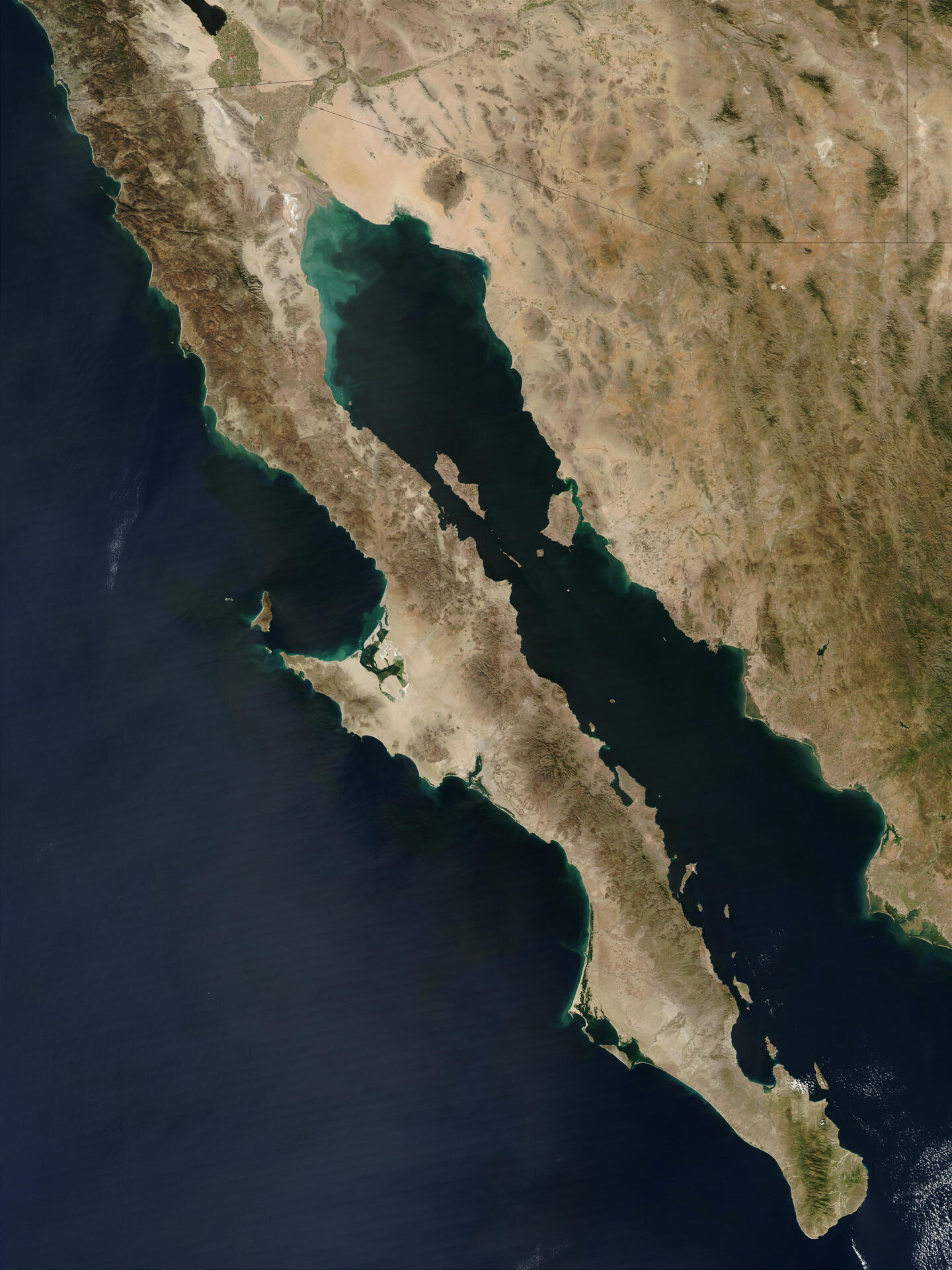
The site comprises 244 islands, islets and coastal areas that are located in the Gulf of California in north-eastern Mexico. The Sea of Cortez and its islands have been called a natural laboratory for the investigation of speciation. Moreover, almost all major oceanographic processes occurring in the planet’s oceans are present in the property, giving it extraordinary importance for study. The site is one of striking natural beauty in a dramatic setting formed by rugged islands with high cliffs and sandy beaches, which contrast with the brilliant reflection from the desert and the surrounding turquoise waters. It is home to 695 vascular plant species, more than in any marine and insular property on the World Heritage List. Equally exceptional is the number of fish species: 891, 90 of them endemic. The site, moreover, contains 39% of the world’s total number of species of marine mammals and a third of the world’s marine cetacean species.
UNESCO Justification of the World Heritage Site
Criterion (vii): The serial property is of stunning landscape beauty with dramatic contrasts between the rugged and seemingly inhospitable islands, coastal deserts and the brilliant reflection from the surrounding turquoise waters. High rocky cliffs and sandy beaches in countless forms and colours rim the islands and coasts. The beauty of the desert landscape is complemented by the fascinating and highly diverse desert vegetation and the ubiquitous birds. To the south, the islands are covered with deciduous vegetation and stand out from the vast blue sea. The diversity and abundance of marine life associated with spectacular submarine terrain and unusual water transparency turn the underwater seascape into a globally renowned diver’s paradise.
Criterion (ix): A major foundation of the Gulf of California's phenomenal marine productivity are nutrient-rich upwelling oceanic currents supporting abundant phytoplankton and zooplankton, which in turn provide nurseries for larval reef fish. However, many other oceanographic processes, such as wind-driven currents, tidal mixing and thermohaline circulation, occur in the property, giving it extraordinary importance for conservation and the study of marine and coastal processes. The Gulf of California is notable for containing ecologically distinct bridge islands, populated across past land bridges, and oceanic islands populated by sea and air. The multitude and diversity of islands in terms of origin, size, environmental conditions and distance to the mainland has enabled an ongoing evolutionary speciation and endemism of major significance for conservation and science. The many components of the property are both part of a vast landscape and distinctive in many ways, ranging from a variety of pelagic and benthic environments to coral reefs, as well as mudflats, coastal wetlands and various types of desert and deciduous forest.
Criterion (x): The diversity of terrestrial and marine life in the property is extraordinary and constitutes a global priority for biodiversity conservation. On land, the close to 700 species of vascular plants are notable within a desert environment. There are 115 species of reptiles, almost half of them endemic, in some cases even to individual islands. 154 land bird species have been recorded and the property is of particular importance to migratory species. Almost 900 species of fish have been documented with some 90 species occurring exclusively in the Gulf of California or parts of it. These include the critically endangered species Black Sea Bass and Totoaba, as well as the vulnerable Basking Shark. The serial property provides habitat for roughly one third of the world’s total number of marine mammals, sometimes in impressive numbers, for example huge colonies of California Sea Lion. The five species of dolphin include the critically endangered Gulf Porpoise or Vaquita. Eleven species of whale visit the northern Gulf, such as the endangered Blue Whale and Fin Whale and the vulnerable Sperm Whale. The coral reef at Cabo Pulmo is one of the most important in the Gulf of California and in the eastern Pacific. The marine habitats also harbour large concentrations of macro-invertebrate life with many endemic species, especially in the intertidal zones.
Encyclopedia Record: Gulf of California
The Gulf of California, also known as the Sea of Cortés or Sea of Cortez, or less commonly as the Vermilion Sea, is a marginal sea of the Pacific Ocean that separates the Baja California peninsula from the Mexican mainland. It is bordered by the states of Baja California, Baja California Sur, Sonora, and Sinaloa with a coastline of approximately 4,000 km (2,500 mi). Rivers that flow into the Gulf of California include the Colorado, Fuerte, Mayo, Sinaloa, Sonora, and the Yaqui. The surface of the gulf is about 160,000 km2 (62,000 sq mi). Maximum depths exceed 3,000 meters (9,800 ft) because of the complex geology, linked to plate tectonics.Additional Site Details
Area: 688,558 hectares
Number of Components: 12
(ix) — Outstanding example representing ecological and biological processes
(x) — Contains most important habitats for biodiversity
Coordinates: 27.62667 , -112.54583
IUCN World Heritage Outlook
The 2025 Conservation Outlook on Islands and Protected Areas of the Gulf of California reports the following assessment:
Source: International Union for Conservation of Nature (IUCN) · View assessment
Image
Unknown, Public domain
