World Heritage Identification Number: 956
World Heritage since: 2000
Category: Cultural Heritage
WHE Type: Historic Cities & Urban Areas
Transboundary Heritage: No
Endangered Heritage: No
Country: 🇸🇳 Senegal
Continent: Africa
UNESCO World Region: Africa
Map
A Cultural and Economic Hub: The Island of Saint-Louis, Senegal
The Island of Saint-Louis, located at the mouth of the Senegal River in West Africa, stands as a testament to the rich history and cultural significance of Senegal. This historic part of the city of Saint-Louis was inscribed onto the UNESCO World Heritage List in 2000, recognizing its unique urban planning, architectural style, and pivotal role in the region's development.
More to come…UNESCO Description of the World Heritage Site
Founded as a French colonial settlement in the 17th century, Saint-Louis was urbanised in the mid-19th century. It was the capital of Senegal from 1872 to 1957 and played an important cultural and economic role in the whole of West Africa. The location of the town on an island at the mouth of the Senegal River, its regular town plan, the system of quays, and the characteristic colonial architecture give Saint-Louis its distinctive appearance and identity.
UNESCO Justification of the World Heritage Site
Criterion (ii): The historic town of Saint-Louis exhibits an important exchange of values and influences on the development of education and culture, architecture, craftsmanship, and services in a large part of West Africa.
Criterion (iv): The Island of Saint-Louis, a former capital of West Africa, is an outstanding example of a colonial city, characterized by its particular natural setting, and it illustrates the development of colonial government in this region.
Encyclopedia Record: Island of Saint-Louis
The Island of Saint-Louis is the historic part of the city of Saint-Louis in Senegal. In 2000, it was inscribed by the UNESCO on the World Heritage list.Additional Site Details
Area: Not available
Number of Components: 1
(iv) — Outstanding example of a type of building or landscape
Coordinates: 16.02778 , -16.50444
Image
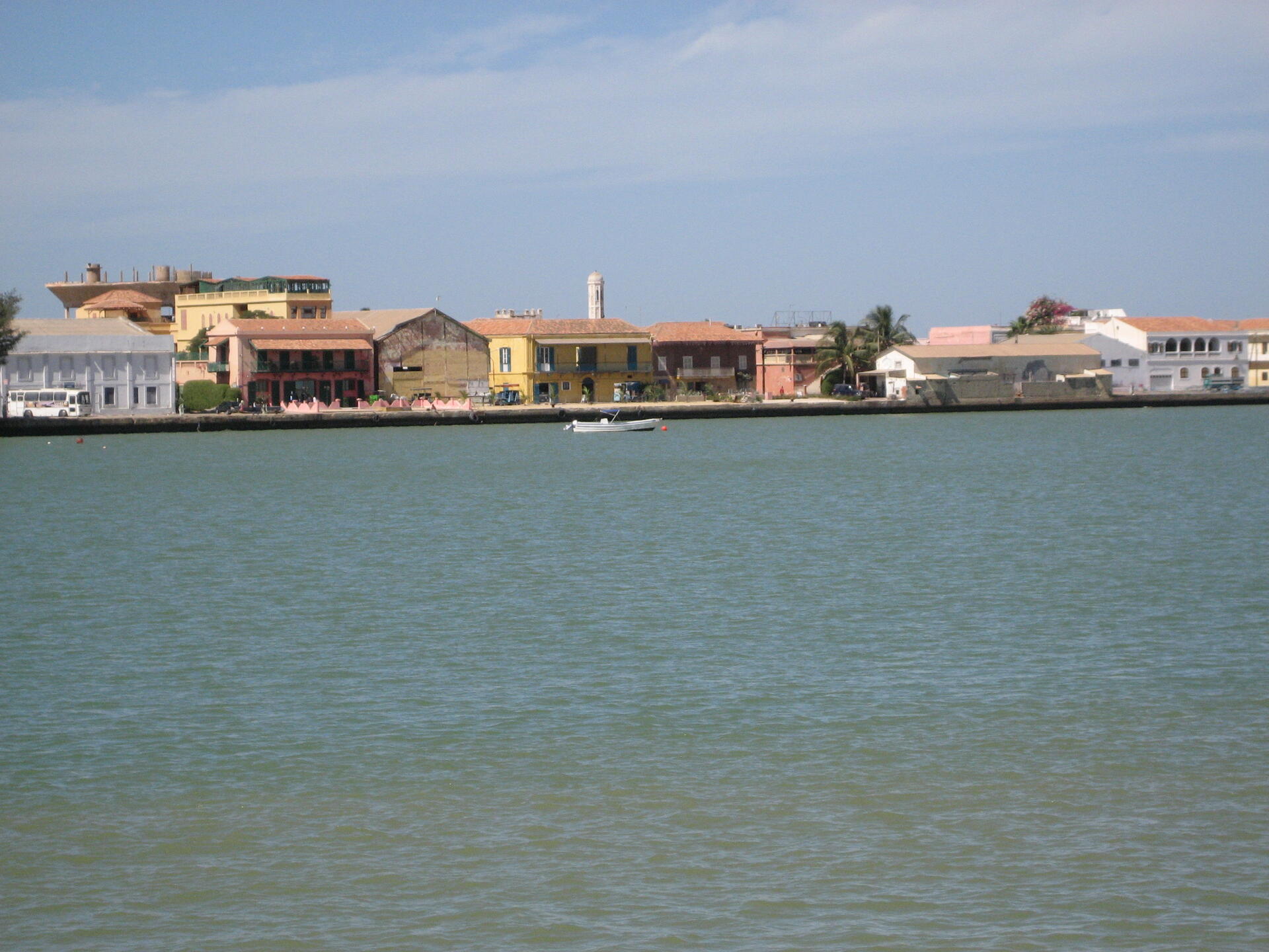
© Jim Williams, CC BY-SA 3.0 igo Resized from original. (This derivative is under the same CC BY-SA license.)
World Heritage Research
Discover scientific research and academic studies that deepen our understanding of Island of Saint-Louis from its history and significance to its conservation, management, and contemporary challenges.
-
Maam Kumba Bang, from the River to the Sea, with Calabash and Curdled Milk
The myth of Maam Kumba Bang, a water deity revered on the Island of Saint-Louis in Senegal, reveals a profound relational ecology where kinship with more-than-human entities fosters horizontal human relationships. This study demonstrates that Maam Kumba Bang serves as an ancestor of relation, shaping the island's ecosystem and cultural practices through rituals performed between the Sénégal River and the Atlantic Ocean. By integrating West African oral traditions with concepts of oceanic kin, the research highlights how shared respect for water underpins social cohesion and ecological vitality. The findings introduce a sensitive epistemology into critical ocean studies, emphasizing the role of myth in sustaining more-than-human relationships and cultural continuity.
Sarr, I. K. N. (2025). Maam Kumba Bang, from the River to the Sea, with Calabash and Curdled Milk. Oceans as Archives, 158–173. https://doi.org/10.4324/9781003594086-14
View Publication Record | Read Publication -
The Seven Years’ War in West Africa
Africa played a pivotal role in the global struggle of European empires during the Seven Years' War, despite its often-overlooked significance. The conflict between French and British forces on the UNESCO World Heritage Sites of Saint-Louis Island and Gorée Island (1758–1759) was not merely a minor sideshow but a critical battleground for controlling trade in gum arabic and disrupting France's transatlantic slave trade. This study reveals how European powers sought to transform African lands into cash crop production hubs, reshaping colonial economies with lasting consequences. By analyzing the immediate and long-term impacts on French and British empires alongside African and Eurafrican communities, it underscores Africa's centrality in the broader geopolitical dynamics of the war.
Røge, P. (2024). The Seven Years’ War in West Africa. The Oxford Handbook of the Seven Years’ War, 487–500. https://doi.org/10.1093/oxfordhb/9780197622605.013.19
View Publication Record | Read Publication -
Size class, density, and distribution of Uca tangeri (Eydoux, 1835; Decapoda: Ocypodidae) in the mangrove ecosystems of Senegal
A comprehensive study on the decapod brachyuran crab, Uca tangeri, reveals significant variations in size and density across Senegal's mangrove ecosystems. The research, conducted in the Senegal River delta, Saloum islands, and Casamance estuary, found that crabs in Saint-Louis exhibit a modal cephalothoracic length of 24–25 mm and weight of 31–32 mm, while those in the Saloum and Casamance regions are smaller, with lengths ranging from 16 to 19 mm and weights from 24 to 26 mm. The study also identified a negative allometric growth pattern (b = 0.8) for both length-weight and height-weight relationships. Notably, Uca tangeri demonstrates no preferential spatial distribution, with an average density of 1.3–1.6 crabs per square meter across the studied mangroves.
Manga, L. S., Faye, A., Fall, J., & Diouf, M. (2023). Size class, density, and distribution of Uca tangeri (Eydoux, 1835; Decapoda: Ocypodidae) in the mangrove ecosystems of Senegal. International Journal of Fisheries and Aquatic Studies, 11(1), 133–140. https://doi.org/10.22271/fish.2023.v11.i1b.2776
View Publication Record | Read Publication -
African Indigo in the French Atlantic: Michel Adanson’s Encounter with Senegal
Michel Adanson's five-year study of African indigo in precolonial Senegal, conducted near the French fort of Saint-Louis, revealed complex transatlantic exchanges of knowledge and material. His experiments, blending European botany with local Wolof expertise, demonstrated how indigo cultivation and dyeing practices connected West Africa to Caribbean colonies like Saint-Domingue and Guyana. Through herbarium sheets, experimental notes, color samples, and correspondence, Adanson's work exposed the interplay between African indigenous knowledge, French imperial ambitions, and colonial plantation economies. The study highlights the material remnants of these encounters—dyed fabrics, maps, and taxonomies—as critical artifacts in understanding global histories of knowledge production.
Terrall, M. (2023). African Indigo in the French Atlantic: Michel Adanson’s Encounter with Senegal. Isis, 114(1), 2–24. https://doi.org/10.1086/723496
View Publication Record | Read Publication -
Migration and the right to survival: An empirical study of three fishing communities in Senegal
A significant portion of Senegalese migrants, particularly local fishers, embark on perilous ocean journeys to Europe and the Canary Islands due to dwindling fish stocks caused by industrial fishing. This study reveals that the decline in small-scale fishing in Senegal has profound implications for the right to survival, food security, and livelihoods of coastal communities in Bargny, Saint-Louis, and Thiaroye. Through semi-structured interviews, researchers captured grassroots perspectives on socioeconomic human rights, highlighting the precarious balance between local fishing practices and industrial exploitation. The findings underscore the urgent need for policies that protect small-scale fishers' rights while addressing the broader impacts of overfishing on food security and migration patterns.
Uwazuruike, A. (2023). Migration and the right to survival: An empirical study of three fishing communities in Senegal. Journal of Rural Studies, 99, 71–78. https://doi.org/10.1016/j.jrurstud.2023.02.007
View Publication Record | Read Publication -
Water, through Words and Evils: The Case of Saint-Louis
The Island of Saint-Louis faces a growing paradox where its rich colonial cultural heritage and unique deltaic environment pose both challenges and opportunities for sustainable development, particularly concerning water management. Research reveals that while water has traditionally been revered by cultures like the Serer people—linked to protective spirits and life rituals—industrialization and urbanization have shifted perceptions, reducing it to a commodity. This transition threatens the site's spiritual and ecological heritage, highlighting the need for balanced strategies that integrate cultural preservation with modern development. The study underscores the vulnerability of water heritage in such contexts while advocating for approaches that leverage local traditions and deltaic conditions to foster resilience.
Ndiaye, M. (2023). Water, through Words and Evils: The Case of Saint-Louis. Blue Papers, 2(2). https://doi.org/10.58981/bluepapers.2023.2.12
View Publication Record | Read Publication -
Ports as bridges between civilisations
Ports, particularly the Port of Saint Louis founded in 1659, serve as critical bridges between civilizations by facilitating interactions among diverse peoples and cultures. This study challenges conventional narratives of colonial African development by analyzing the complex interrelationships between ports and their shifting hinterlands. It reveals that multiple forces—including colonial administrations, commercial companies, indigenous political authorities, religious leaders, trading networks, local communities, and households—shaped spatial organization in Senegal's regions. The dynamic relationship between Senegalese port-cities and their hinterlands reflects broader colonial policies driven by economic, political, and social objectives. By examining these interactions, the research offers a nuanced understanding of how ports functioned as cultural and economic hubs, linking Africa to global networks.
Bruschi, F. (2022). Ports as bridges between civilisations. Port-Cities and Their Hinterlands, 230–255. https://doi.org/10.4324/9780429202254-9
View Publication Record | Read Publication