World Heritage Identification Number: 499
World Heritage since: 1988
Category: Cultural Heritage
WHE Type: Historic Cities & Urban Areas
Transboundary Heritage: No
Endangered Heritage: No
Country: 🇹🇳 Tunisia
Continent: Africa
UNESCO World Region: Arab States
Map
Kairouan: The Ancient Holy City of Tunisia
Kairouan (Arabic: القيروان, Al-Qayrawān), officially known as Nour Essaf (Arabic: نور الصف, meaning "Light of the Row"), is a historic city located in central Tunisia, serving as the capital of the Kairouan Governorate. Established in 670 AD during the reign of Caliph Mu'awiya I, Kairouan has been a significant center for Sunni Islamic scholarship and Quranic learning since its founding, attracting Muslims from across the globe. In recognition of its historical and cultural significance, Kairouan was designated a UNESCO World Heritage Site in 1988.
More to come…UNESCO Description of the World Heritage Site
Founded in 670, Kairouan flourished under the Aghlabid dynasty in the 9th century. Despite the transfer of the political capital to Tunis in the 12th century, Kairouan remained the Maghreb's principal holy city. Its rich architectural heritage includes the Great Mosque, with its marble and porphyry columns, and the 9th-century Mosque of the Three Gates.
UNESCO Justification of the World Heritage Site
Criterion (i): The Great Mosque, rebuilt in the 9th century, is not only one of the major monuments of Islam but also a universal architectural masterpiece. The many but small changes in it have not altered the layout of this place of prayer, which forms a quadrilateral of 135 m by 80 m. At its southern end is a hypostyle prayer room with 17 naves supported by a « forest » of columns in marble and porphyry. On the north is a vast flagstone courtyard bordered with porticoes, interrupted in the middle of the smaller northern end by the massive square-shaped three-storey minaret.
Criterion (ii): The Great Mosque served as a model for several Maghreban mosques, particularly for its decorative motifs, which are unique. Moreover, the Mosque of the Three Doors, built in 866 AD, is the oldest known Islamic mosque with a sculpted facade.
Criterion (iii): With the Great Mosque, the Mosque of the Three Doors, and the Basin of the Aghlabids, not to mention the numerous archaeological vestiges, Kairouan bears exceptional witness to the civilisation of the first centuries of the Hegira in Ifrîqiya.
Criterion (v): Protected by its walls and gates (Bab et Tounes, Bab el Khoukha, Bab ech Chouhada), the medina of Kairouan, whose skyline is punctuated by the minarets and the cupolas of its mosques and zawiyas, has preserved its network of winding streets and courtyard houses. Very few small windows or arched doorways are cut in the exterior walls, but inner walls have larger openings that give onto the central courtyard. This traditional architecture, having become vulnerable through the impact of socio-economic changes, constitutes a valuable heritage which must be protected in its entirety.
Criterion (vi): Kairouan is one of the holy cities and spiritual capitals of Islam. Next to the Great Mosque, the first place of worship founded in the Maghreb only 38 years after the death of the Prophet, is the Zawiya of Sidi Sahâb where the remains of Abu Djama, one of Mahomet’s companions, are kept. It is not surprising that in the past, seven pilgrimages to Kairouan could take the place of the one pilgrimage to Mecca prescribed for all Muslims.
Encyclopedia Record: Kairouan
Kairouan, also spelled El Qayrawān or Kairwan, is the capital of the Kairouan Governorate in Tunisia and a UNESCO World Heritage Site. The city was founded by the Umayyads around 670, in the period of Caliph Mu'awiya ; this is when it became an important centre for Sunni Islamic scholarship and Quranic learning, attracting Muslims from various parts of the world. The Mosque of Uqba is situated in the city.Additional Site Details
Area: 68.02 hectares
Number of Components: 4
(ii) — Significant interchange of human values
(iii) — Unique or exceptional testimony to a cultural tradition
(v) — Outstanding example of traditional human settlement
(vi) — Directly associated with events or living traditions
Coordinates: 35.68167 , 10.10389
Image
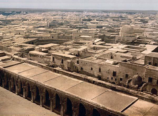
Unknown author, Public domain
World Heritage Research
Discover scientific research and academic studies that deepen our understanding of Kairouan from its history and significance to its conservation, management, and contemporary challenges.
-
Kairouan Manuscript Cultures / Cultures des manuscrits à Kairouan
The Kairouan Collection, housed at the National Laboratory for the Preservation and Conservation of Parchment and Manuscripts in Raqqada, Tunisia, represents one of the oldest near-intact collections of Islamic manuscripts globally, with many dating back before 900 CE. This collection offers a rare opportunity to study the evolution and use of Islamic manuscripts over a millennium, supported by historical records from early Kairouan scholars and colonial-era documentation. The study provides unprecedented insights into the cultural and intellectual history of the region, bridging gaps between ancient manuscript traditions and modern scholarly inquiry.
Brockopp, J. E., & Helali, A. (Eds.). (2026). Kairouan Manuscript Cultures / Cultures des manuscrits à Kairouan. https://doi.org/10.5325/b.20269546
View Publication Record | Read Publication -
Kairouan and the medieval ceramic industry in Tunisia: New data from compositional analysis of glazed and unglazed wares from the sites of Bulla Regia and Chimtou
A new study reveals that Kairouan was a significant medieval ceramic production center in Tunisia, with its wares distributed across the Medjerda Valley. Analysis of 65 glazed and unglazed ceramics (9th-12th centuries) from Bulla Regia and Chimtou using thin section petrography, LA-ICP-MS, and SEM-EDS shows that most were locally manufactured in central Tunisia, with only two imports from Sicily. The findings suggest Kairouan's workshops specialized in different ceramic types, while smaller regional production centers may have also contributed to the supply chain. All glazes were lead-based, primarily translucent, with a few tin-opacified, indicating complex sourcing and recycling of lead from silver extraction byproducts.
Occari, V., Fenwick, C., Möller, H., Quinn, P. S., Freestone, I. C., Sacco, V., von Rummel, P., & Chaouali, M. (2025). Kairouan and the medieval ceramic industry in Tunisia: New data from compositional analysis of glazed and unglazed wares from the sites of Bulla Regia and Chimtou. Journal of Archaeological Science: Reports, 66, 105245. https://doi.org/10.1016/j.jasrep.2025.105245
View Publication Record | Read Publication -
Water Footprint of Cereals by Remote Sensing in Kairouan Plain (Tunisia)
A study on the Kairouan plain, Tunisia, reveals that cereal crops—wheat and barley—exhibit significant variability in water efficiency, with over 30% of cultivated areas showing low yields coupled with high water consumption. This inefficiency is particularly pronounced during dry years, where blue water footprint (WFb) dominates, indicating unsustainable irrigation practices. The research employed the S-SEBI model to estimate actual evapotranspiration (ETa) using Landsat satellite data and an empirical NDVI-based model for yield estimation over three growing seasons (2010–2013). Findings highlight that while average water footprints ranged from 1.08 m³/kg to 1.22 m³/kg, spatial analysis using a novel Water Footprint Index (WFI) exposed critical inefficiencies in water use, with 40% of low-yield plots irrigated in 2012—contrasting sharply with 6% in 2011. This underscores the need for targeted interventions to optimize water management in cereal production under varying climatic conditions.
Dellaly, V., Chahbi Bellakanji, A., Chakroun, H., Saadi, S., Boulet, G., Zribi, M., & Lili Chabaane, Z. (2024). Water Footprint of Cereals by Remote Sensing in Kairouan Plain (Tunisia). Remote Sensing, 16(3), 491. https://doi.org/10.3390/rs16030491
View Publication Record | Read Publication -
The Earliest Manuscripts of Kairouan (9th-11th Centuries): New Approaches for a More Accurate Dating
A groundbreaking analysis of 32 Kairouan manuscripts from the 9th to 11th centuries challenges traditional dating methods, revealing that some dated notes may not reflect the actual production time but rather earlier events like readings or auditions. This finding undermines established termini ante quem for manuscript dating. The study also introduces new palaeographic criteria to better understand Ifrīqī scripts, tracing their origin and development with unprecedented precision. By re-evaluating paratextual content and script features, researchers provide a more accurate framework for contextualizing these historically significant manuscripts, offering fresh insights into Islamic scholarly traditions in early medieval Kairouan.
Bongianino, U., & Salah, C. (2024). The Earliest Manuscripts of Kairouan (9th-11th Centuries): New Approaches for a More Accurate Dating. Arabica, 71(3), 247–303. https://doi.org/10.1163/15700585-202416893
View Publication Record | Read Publication -
The Developmental Stages of the Inner Courtyard of the Mosque: an Analytical Study of (Kairouan Mosque and Mosque of Sultan Hassan Shrine)
A key insight from this study is that the inner courtyard of Islamic mosques, including those at Kairouan and Sultan Hassan Shrine, has consistently served as a multifunctional space, evolving with aesthetic elements to enhance both functionality and beauty. The research reveals that engineering ratios played a pivotal role in shaping these courtyards' layouts, ensuring their significance across different eras and architectural styles. By analyzing historical developments, the study highlights the courtyard's enduring importance—its privacy and centrality to mosque design—while demonstrating how it adapted to serve diverse purposes during Islamic rule.
Thabit Al-Baldawi, M. (2023). The Developmental Stages of the Inner Courtyard of the Mosque: an Analytical Study of (Kairouan Mosque and Mosque of Sultan Hassan Shrine). Dirasat: Human and Social Sciences, 50(1), 32–55. https://doi.org/10.35516/hum.v50i1.4387
View Publication Record | Read Publication -
Applying Multivariate Analysis and Machine Learning Approaches to Evaluating Groundwater Quality on the Kairouan Plain, Tunisia
Groundwater on the Kairouan Plain, Tunisia, exhibits diverse chemical characteristics primarily influenced by water–rock interaction, dolomite dissolution, evaporation, and ion exchange. Analysis revealed three distinct water types: Ca-Mg-SO4, Na-Cl, and mixed Ca-Mg-Cl/SO4, with ions following the order Na+ > Ca2+ > Mg2+ > K+ and SO42− > HCO3− > Cl−. While most groundwater is suitable for agriculture, irrigation water quality indices (IWQIs) indicate high-to-severe restrictions in some areas. Machine learning models, particularly ANN-HyC-9 and XGBoost regression, demonstrated high accuracy in predicting IWQIs, with R² values exceeding 0.823 for testing datasets. These findings provide critical insights for sustainable water resource management.
Salem, S., Gaagai, A., Ben Slimene, I., Moussa, A., Zouari, K., Yadav, K., Eid, M., Abukhadra, M., El-Sherbeeny, A., Gad, M., Farouk, M., Elsherbiny, O., Elsayed, S., Bellucci, S., & Ibrahim, H. (2023). Applying Multivariate Analysis and Machine Learning Approaches to Evaluating Groundwater Quality on the Kairouan Plain, Tunisia. Water, 15(19), 3495. https://doi.org/10.3390/w15193495
View Publication Record | Read Publication -
Vulnérabilité de la population face aux fortes chaleurs dans l’agglomération de Kairouan (Tunisie centrale)
A significant increase in heat intensity and prolonged heatwaves, particularly in the last three years, has been observed in Kairouan, Tunisia. This study highlights that the city's population, especially those residing in unplanned neighborhoods, is highly vulnerable to these extreme conditions. Adaptation strategies during heatwaves are largely influenced by household income levels, with lower-income populations facing greater challenges. The research combines meteorological data from 1980 to 2023 with a survey of 425 residents, revealing spatial disparities in vulnerability and the socio-economic factors shaping adaptive responses.
Chebli, M., Dahech, S., & Charfi, S. (2023). Vulnérabilité de la population face aux fortes chaleurs dans l’agglomération de Kairouan (Tunisie centrale). EchoGéo, 66. https://doi.org/10.4000/echogeo.26014
View Publication Record | Read Publication