World Heritage Identification Number: 1145
World Heritage since: 2004
Category: Cultural Heritage
WHE Type: Archaeological Sites
Transboundary Heritage: No
Endangered Heritage: No
Country: 🇰🇿 Kazakhstan
Continent: Asia
UNESCO World Region: Asia and the Pacific
Map
Exploring the Petroglyphs of the Archaeological Landscape of Tanbaly: A Journey Through Time
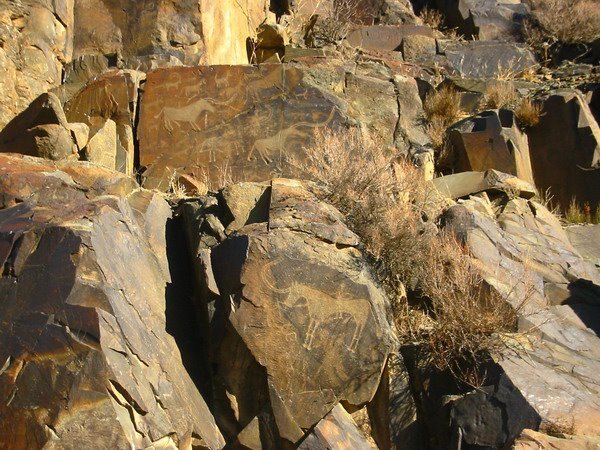
The Petroglyphs of the Archaeological Landscape of Tanbaly, inscribed as a UNESCO World Heritage Site in 2004, offer a unique glimpse into the rich history and cultural practices of pastoral societies that once inhabited the region now known as Kazakhstan. Situated within the verdant Tanbaly Gorge, nestled amidst the expansive, arid Chu-Ili mountains, this remarkable site boasts over 5,000 petroglyphs, or rock carvings, spanning from the second half of the second millennium BC to the beginning of the 20th century.
More to come…UNESCO Description of the World Heritage Site
Set around the lush Tanbaly Gorge, amidst the vast, arid Chu-Ili mountains, is a remarkable concentration of some 5,000 petroglyphs (rock carvings) dating from the second half of the second millennium BC to the beginning of the 20th century. Distributed among 48 complexes with associated settlements and burial grounds, they are testimonies to the husbandry, social organization and rituals of pastoral peoples. Human settlements in the site are often multilayered and show occupation through the ages. A huge number of ancient tombs are also to be found including stone enclosures with boxes and cists (middle and late Bronze Age), and mounds (kurgans) of stone and earth (early Iron Age to the present). The central canyon contains the densest concentration of engravings and what are believed to be altars, suggesting that these places were used for sacrificial offerings.
UNESCO Justification of the World Heritage Site
Criterion (iii): The dense and coherent group of petroglyphs, with sacred images, altars and cult areas, together with their associated settlements and burial sites, provide a substantial testimony to the lives and beliefs of pastoral peoples of the central Asian steppes from the Bronze Age to the present day.
Encyclopedia Record: Tanbaly
Tamgaly is a petroglyph site in the Zhetysu of Kazakhstan. Tamgaly became a UNESCO World Heritage Site in 2004. Tamgaly is located 170 km northwest of Almaty.Additional Site Details
Area: 900 hectares
Number of Components: 1
Coordinates: 43.80333333 , 75.535
World Heritage Research
Discover scientific research and academic studies that deepen our understanding of Petroglyphs of the Archaeological Landscape of Tanbaly from its history and significance to its conservation, management, and contemporary challenges.
-
A Preliminary Study on the Comparison between the Petroglyphs of Temiya and Fugoppe Caves in Japan and the Petroglyphs of Tanbaly in Kazakhstan
A comparative analysis of petroglyphs from Temiya and Fugoppe Caves in Japan with those of Tanbaly in Kazakhstan reveals shared motifs, including human figures, animals, fish, and shamans, despite geographical and cultural differences. While both regions depict similar themes, Tanbaly's inland location explains the absence of boat representations found in Japan, and its diverse animal imagery reflects local ecological conditions. Differences in shamanic symbols suggest varying spiritual practices. The study highlights how rock art serves as a reflection of subsistence practices shaped by geography and environmental context, offering insights into prehistoric cultural adaptations.
Ninomiya, T., Bazarbay, Zh. M., & Gabitov, T. Kh. (2026). A PRELIMINARY STUDY ON THE COMPARISON BETWEEN THE PETROGLYPHS OF TEMIYA AND FUGOPPE CAVES IN JAPAN AND THE PETROGLYPHS OF TANBALY IN KAZAKHSTAN. Вестник КазНПУ Имени Абая. Серия: Исторические И Социально-Политические Науки, 89(2). https://doi.org/10.51889/2959-6017.2026.89.2.010
View Publication Record | Read Publication -
New Tamga Petroglyphs from the Zhetyzhol Ridge: Akterek, Basbatyr and Karakyr (Almaty region, Kazakhstan)
Researchers have documented 20 new tamga petroglyphs from three sites—Akterek, Basbatur, and Karakyr—in Kazakhstan's Almaty region. These tamgas, clan or family emblems dating from the Early Turkic period to the early 20th century, include two previously unpublished examples from Akterek and Karakyr. The study challenges existing chronological attributions for three signs at Basbatur, suggesting they may date to the late Saka period rather than the Early Turkic era. Additionally, it raises questions about potential connections between these tamga-like signs in Kazakhstan and similar findings in Mongolia. The research contributes new visual documentation of these symbols, inviting further discussion on their cultural significance and historical context.
Hermann, L., & Zheleznyakov, B. (2025). New Tamga Petroglyphs from the Zhetyzhol Ridge: Akterek, Basbatyr and Karakyr (Almaty region, Kazakhstan). Археология Казахстана, (1 (27)), 253–269. https://doi.org/10.52967/akz2025.1.27.253.269
View Publication Record | Read Publication -
Archaeological Research the Karatau Mountains in 2001–2008 (Based Materials of the Turan Archaeological Expedition)
Archaeological research in the Karatau Mountains, conducted between 2001 and 2008 by the Turan Archaeological Expedition, revealed significant insights into the historical and cultural development of medieval settlements and petroglyph sites. The study identified 15 locations with petroglyphs, including notable sites like Tanbaly-Tas and Kiyinzhuerek, which depict religious, mythological, hunting, and animal husbandry scenes. These findings provide a comprehensive understanding of the worldview and cultural practices of ancient communities in the region. The research employed archaeological methods such as surveys, explorations, and excavations to analyze structural features, cultural layers, and archaeological complexes at medieval settlements like Kultobe and Karashyk. This systematic approach has clarified processes of historical development and urban culture formation, offering valuable data for future scientific directions.
Moldakhmet, A. (2025). ARCHAEOLOGICAL RESEARCH THE KARATAU MOUNTAINS IN 2001–2008 (BASED MATERIALS OF THE TURAN ARCHAEOLOGICAL EXPEDITION). Cultural Heritage, 109(2), 6–25. https://doi.org/10.47500/2025.v22.i2.01
View Publication Record | Read Publication