
World Heritage Identification Number: 1490
World Heritage since: 2016
Category: Natural Heritage
WHE Type: Protected Areas & National Parks
Transboundary Heritage: Yes
Endangered Heritage: No
Country: Kazakhstan, Kyrgyzstan, Uzbekistan
Continent: Asia
UNESCO World Region: Asia and the Pacific
Map
The Western Tien-Shan: A Transboundary Treasure Trove of Biodiversity
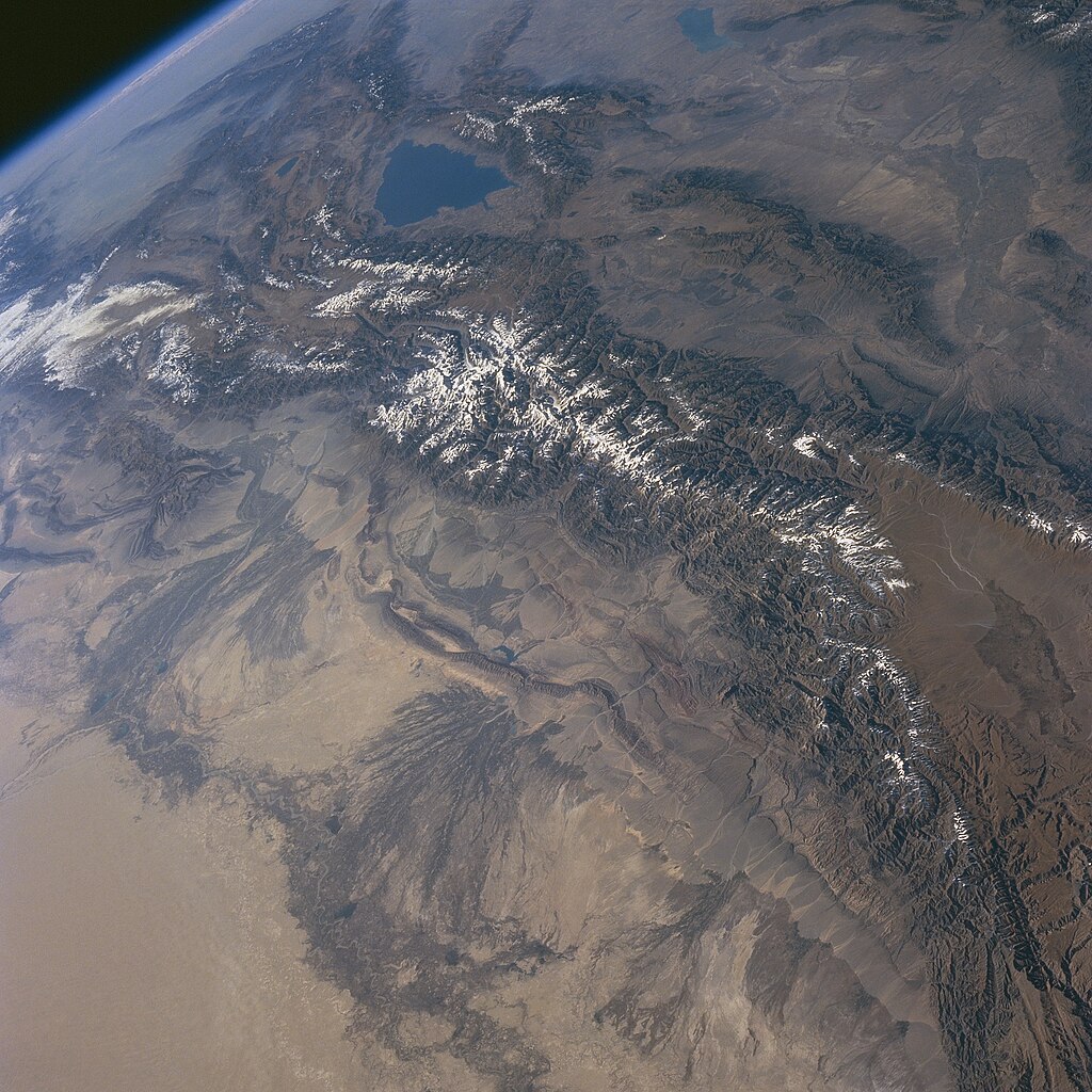
The Western Tien-Shan, inscribed as a UNESCO World Heritage Site in 2016, is a captivating transboundary region nestled within the expansive Tien-Shan mountain system, one of the most extensive mountain ranges globally. This vast territory spans across Kazakhstan, Kyrgyzstan, and Uzbekistan, showcasing a breathtaking array of landscapes that harbor an extraordinary wealth of biodiversity.
More to come…UNESCO Description of the World Heritage Site
The transnational property is located in the Tien-Shan mountain system, one of the largest mountain ranges in the world. Western Tien-Shan ranges in altitude from 700 to 4,503 m. It features diverse landscapes, which are home to exceptionally rich biodiversity. It is of global importance as a centre of origin for a number of cultivated fruit crops and is home to a great diversity of forest types and unique plant community associations.
UNESCO Justification of the World Heritage Site
Criterion (x): The Western Tien-Shan supports a high diversity of different types of forests and unique combinations of plant communities characteristic of the Mountains of Central Asia biodiversity hotspot. The property hosts an outstanding diversity of plant and animal species, including endemic species and many species of global conservation importance. The property’s main attributes are rare bird and plant species, wild relatives of commercial fruit trees, as well as threatened mammal species. The vertebrate biodiversity in the region of Western Tien-Shan reported at the time of inscription includes 61 species of mammals, 316 species of birds, 17 species of reptiles, 3 species of amphibians and several fish species, with many of these species also reported as occurring in the area of the property. The occurrence of further species may be confirmed by additional research. The Western Tien-Shan supports a significant number of species of flora and fauna considered as globally threatened at the time of inscription. Several wild relatives of today’s commercial fruit trees occur within the property such as Wild Apricot, Common Walnut, and Sievers Apple, which is present in all component parts, and which is considered the progenitor of vast majority of today’s apple varieties. Other rare species include Crataegus knorringiana, Lonicera karataviensis, Betula talassica, and Spiraeanthus schrenkianus. Over 20% of the world’s cereals, vegetable and spice plants, and 90% of the major temperate-zone fruit crops are found in the region. Regarding the property’s fauna, the Snow Leopard, Argali and Menzbier’s Marmot are amongst the key species. The endemic Menzbier’s Marmot inhabits territories in all three countries with a population of more than 26,000 was reported at the time of inscription. The Argali is present in most component parts, with more than 500 individuals of two subspecies recorded. The Snow Leopard uses all but one component part with 20 individuals recorded at the time of inscription, though significant data gaps remained. More than 40 Saker Falcons and around 300 Cinereous Vultures were recorded at the time of inscription, though data gaps remained. Both are present in all component parts. Around 100 Egyptian Vultures were recorded at the time of inscription.
Encyclopedia Record: Tian Shan
The Tian Shan, also known as the Tengri Tagh or Tengir-Too, is a large system of mountain ranges in Central Asia. The highest peak is Jengish Chokusu at 7,439 metres (24,406 ft) high and located in Kyrgyzstan. Its lowest point is at the Turpan Depression, which is 154 m (505 ft) below sea level.Additional Site Details
Area: 528,177.6 hectares
Number of Components: 13
Coordinates: 43.7183333333 , 68.6788888889
IUCN World Heritage Outlook
The 2025 Conservation Outlook on Western Tien-Shan reports the following assessment:
Source: International Union for Conservation of Nature (IUCN) · View assessment
Image
NASA, Public domain
World Heritage Research
Discover scientific research and academic studies that deepen our understanding of Western Tien-Shan from its history and significance to its conservation, management, and contemporary challenges.
-
Occurrence and Characteristics of Rock Glaciers in Western Tien Shan
Researchers have identified 741 rock glaciers in the Western Tien Shan, covering over 70.5 km², with a significant concentration on north-facing slopes due to reduced solar radiation. These rock glaciers, acting as resilient water reservoirs in arid mountains, exhibit varying kinematic activity influenced by elevation, slope, aspect, and local topography. The study, the first of its kind in this region, reveals that while most are active or transitional with mean seasonal displacement rates of ~15 cm/year, their distribution and behavior suggest a lower permafrost boundary at approximately 1922 m above sea level. This inventory not only establishes a benchmark dataset for global permafrost models but also highlights the importance of rock glaciers in permafrost monitoring and water resource assessment in data-scarce mountain regions.
Merekeyev, A., Nurakynov, S., Bolch, T., Iskaliyeva, G., Talgarbayeva, D., & Sydyk, N. (2026). Occurrence and Characteristics of Rock Glaciers in Western Tien Shan. Water, 18(3), 367. https://doi.org/10.3390/w18030367
View Publication Record | Read Publication -
Long-Term Spatiotemporal Dynamics of Snow Cover in the Arys River Basin (Western Tien Shan)
A long-term analysis of snow cover dynamics in the Arys River basin (Western Tien Shan) reveals significant interannual variability and a weak but notable decline in snow-covered area, averaging 0.37% per year between 2000–2024. The study, leveraging MODIS satellite data and validated against meteorological station records, found the most pronounced reductions at mid-elevation zones. These trends suggest growing risks to seasonal water availability, particularly under ongoing climate change, with implications for water resource management in Central Asia's Syr Darya basin.
Koshim, A., Takibayev, Z., Gafurov, A., Munaitpassova, A., Kanatkaliyev, D., Bekzhanova, A., Zhumalipov, A., & Sharapkhanova, Z. (2026). Long-Term Spatiotemporal Dynamics of Snow Cover in the Arys River Basin (Western Tien Shan). Hydrology, 13(4), 115. https://doi.org/10.3390/hydrology13040115
View Publication Record | Read Publication -
Mesozoic-Cenozoic Intramountain Basins of the Tien Shan and Western Transbaikalia: Comparative Characteristics and Correlation of Events Article 1. Question Formulation. Intramountain Basins of the Gissar-Alai and Central Tien Shan
A comparative analysis of Mesozoic-Cenozoic intramountain basins in the Eurasian intracontinental orogen reveals that these regions, including the Western and Central Tien Shan, were zones of dispersed shear flow. This dynamic process led to the formation and evolution of a system of depressions and uplifts, driven by the redistribution of rock masses during rheid deformation under conditions of vertical and lateral rheological heterogeneity in the crust. The study employs a multidisciplinary approach, including geological analysis, structural and tectonic research, geomapping, lithological section descriptions, experimental tectonophysics, and magnetotelluric sounding, to elucidate regional geodynamic development features. This first article in a series sets the foundation for further exploration of depressions in Western Transbaikalia and broader correlations of events.
Leonov, M. G., Przhiyalgovskii, E. S., Morozov, Yu. A., Lunina, O. V., Mazukabzov, A. M., & Nikitin, А. V. (2025). MESOZOIC-CENOZOIC INTRAMOUNTAIN BASINS OF THE TIEN SHAN AND WESTERN TRANSBAIKALIA: COMPARATIVE CHARACTERISTICS AND CORRELATION OF EVENTS ARTICLE 1. QUESTION FORMULATION. INTRAMOUNTAIN BASINS OF THE GISSAR-ALAI AND CENTRAL TIEN SHAN. Geodynamics & Tectonophysics, 16(3), 826. https://doi.org/10.5800/gt-2025-16-3-0826
View Publication Record | Read Publication -
Gagea kotuchovii (Liliaceae) a new species from the Karatau Mountains (western Tian Shan, Kazakhstan) evidenced by morphological and molecular analyses
Researchers have identified and described Gagea kotuchovii, a new narrow endemic species of the Liliaceae family, exclusive to the Karatau Mountains in South Kazakhstan. This discovery was supported by both morphological and molecular analyses, including phylogenetic studies using nuclear DNA (ITS) and genome-wide sequencing (DArT). The species is distinguished by its unique bulb with a densely woolly sheath and the presence of multiple stolons of varying lengths on a single vegetative individual. Additionally, the study provides an identification key for Asian Gagea species with stolons, facilitating morphological differentiation. Phylogenetic analyses also revealed the species' isolated position while confirming its relation to morphologically similar taxa, contributing to the understanding of intergeneric organization in Kazakhstan and Middle Asia.
Kubentayev, S., Levichev, I., Baasanmunkh, S., Klichowska, E., Alibekov, D., Choi, H. J., & Nobis, M. (2025). Gagea kotuchovii (Liliaceae) a new species from the Karatau Mountains (western Tian Shan, Kazakhstan) evidenced by morphological and molecular analyses. PLOS One, 20(12), e0336223. https://doi.org/10.1371/journal.pone.0336223
View Publication Record | Read Publication -
A new, highly endangered and restricted-range species of Parrya sect. Pseudoclausia, comb. nov. (Brassicaceae) from Western Tian Shan, Uzbekistan
Researchers have identified Parrya tojibaevii, a new species of flowering plant in the Brassicaceae family, endemic to a highly disturbed area around the confluence of the Chatkal River and Charvak Reservoir in Western Tian Shan, Uzbekistan. This species is morphologically distinct from related taxa, such as P. gracillima and P. mollissima, and belongs to the newly recognized Parrya sect. Pseudoclausia. The discovery highlights the species' critically endangered status due to its restricted range, which is under growing threat from infrastructure development, recreation, and grazing. The study combines morphological analysis with field observations to document this novel taxon, emphasizing the urgency of conservation efforts for this unique and vulnerable plant.
GERMAN, D. A., MADAMINOV, F. M., & BESHKO, N. Yu. (2024). A new, highly endangered and restricted-range species of Parrya sect. Pseudoclausia, comb. nov. (Brassicaceae) from Western Tian Shan, Uzbekistan. Phytotaxa, 633(2), 145–154. https://doi.org/10.11646/phytotaxa.633.2.5
View Publication Record | Read Publication -
InSAR coseismic deformation field and seismogenic structure of the 2020 Mw6.0 Jiashi earthquake and the implication for the moderate-magnitude seismicity in the southwestern Tian Shan, western China
A 2020 Mw6.0 earthquake in the Jiashi region of China's southwestern Tian Shan revealed right-lateral transpressive motion with no surface ruptures, despite significant subsurface deformation. Using Sentinel-1A satellite data, researchers reconstructed the coseismic deformation field, overcoming orbital phase limitations through a novel method combining ascending and descending track data with terrain features. The study identified a north-dipping fault plane at 4.2 km depth, with a strike of 276° and dip angle of 11.6°, aligning partially with USGS focal mechanism solutions but differing from others. This event's limited rupture to the surface is attributed to irregularities in fault geometry and lower rock strength above the detachment. The findings advance understanding of seismic behavior in fold-and-thrust belts, particularly for moderate-magnitude seismicity in the region.
Wu, D., Chen, Z., & Zimin, M. (2024). InSAR coseismic deformation field and seismogenic structure of the 2020 Mw6.0 Jiashi earthquake and the implication for the moderate-magnitude seismicity in the southwestern Tian Shan, western China. Frontiers in Earth Science, 11. https://doi.org/10.3389/feart.2023.1305519
View Publication Record | Read Publication -
Autumn Migration of the Rare Yellow-Eyed Pigeon Columba eversmanni from Western Tian Shan (Tanyrtau), Kazakhstan
The Yellow-eyed Pigeon (Columba eversmanni), a globally endangered species, exhibits rapid autumn migration with maximum travel rates of 257 km/day and 243 km/day, averaging 102 km/day over distances exceeding 1000 km. Tracking two individuals via GPS/GSM transmitters revealed their flyway through southern Kazakhstan, eastern Uzbekistan, and northern Afghanistan, highlighting critical stopover sites in forest belts, crop fields, and rural areas. Night-time roosting preferences included trees in agricultural landscapes and buildings. These findings underscore the importance of large-scale tracking to elucidate migration patterns, identify threats, and inform conservation strategies for this rare Central Asian pigeon.
Berdikulov, B. T., Gavrilov, A. E., Ilina, V. O., Song, G., & Lei, F. M. (2024). Autumn Migration of the Rare Yellow-Eyed Pigeon Columba eversmanni from Western Tian Shan (Tanyrtau), Kazakhstan. Ardea, 112(1). https://doi.org/10.5253/arde.2023.a12
View Publication Record | Read Publication