World Heritage Identification Number: 1414
World Heritage since: 2013
Category: Natural Heritage
WHE Type: Protected Areas & National Parks
Transboundary Heritage: No
Endangered Heritage: No
Country: 🇨🇳 China
Continent: Asia
UNESCO World Region: Asia and the Pacific
Map
Xinjiang Tianshan: A Unique Landscape of Contrasting Environments in Central Asia
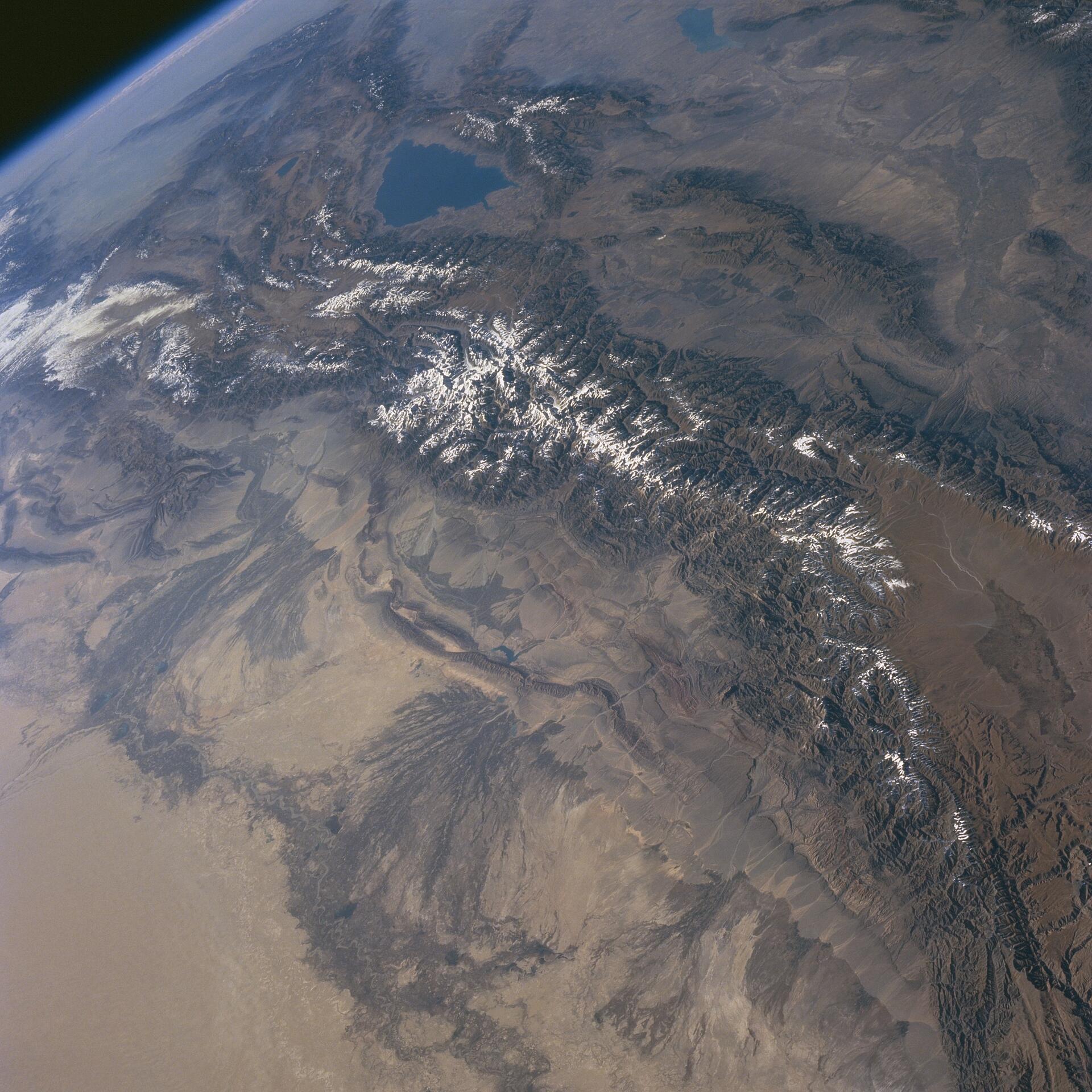
The Xinjiang Tianshan, inscribed as a UNESCO World Heritage Site in 2013, is a captivating testament to the diverse and stunning landscapes found within the Tianshan mountain system of Central Asia. Spanning over 606,833 hectares across four distinct components – Tomur, Kalajun-Kuerdening, Bayinbukuke, and Bogda – this expansive region offers a rich tapestry of natural wonders, from snow-capped peaks to arid deserts.
More to come…UNESCO Description of the World Heritage Site
Xinjiang Tianshan comprises four components—Tomur, Kalajun-Kuerdening, Bayinbukuke and Bogda— that total 606,833 hectares. They are part of the Tianshan mountain system of Central Asia, one of the largest mountain ranges in the world. Xinjiang Tianshan presents unique physical geographic features and scenically beautiful areas including spectacular snow and snowy mountains glacier-capped peaks, undisturbed forests and meadows, clear rivers and lakes and red bed canyons. These landscapes contrast with the vast adjacent desert landscapes, creating a striking visual contrast between hot and cold environments, dry and wet, desolate and luxuriant. The landforms and ecosystems of the site have been preserved since the Pliocene epoch and present an outstanding example of ongoing biological and ecological evolutionary processes. The site also extends into the Taklimakan Desert, one of the world’s largest and highest deserts, known for its large dune forms and great dust storms. Xinjiang Tianshan is moreover an important habitat for endemic and relic flora species, some rare and endangered.
UNESCO Justification of the World Heritage Site
Criterion (vii): The Tianshan is a large mountain range in Central Asia stretching about 2,500 kilometers. It is the largest mountain chain in the world’s temperate arid region, and the largest isolated east-west mountain range globally. The Xinjiang portion of the Tianshan runs east-west for 1,760km and is a mountain range of outstanding natural beauty. The Xinjiang Tianshan is anchored in the west by the highest peak in the Tianshan, Tomur Peak at 7,443 meters, and in the east by Bogda Peak at 5,445 meters. The range lies between two Central Asian deserts, Junggar Desert in the north and the Tarim Desert in the south. The beauty of the Xinjiang Tianshan lies not only in its spectacular snow-capped mountains and glacier-capped peaks, beautiful forests and meadows, clear rivers and lakes and red bed canyons, but also in the combination and contrast between the mountain elements and the vast deserts. The stark difference of bare rocks on its south slope and luxuriant forest and meadow on the north creates a striking visual contrast of environments which are hot and cold, dry and wet, desolate and luxuriant – and of exceptional beauty.
Criterion (ix): Xinjiang Tianshan is an outstanding example of ongoing biological and ecological evolutionary process in a temperate arid zone. The landforms and ecosystems have been preserved since the Pliocene epoch because of the Tianshan’s position between two deserts and its Central Asian arid continental climate, which is unique among the world's mountain ecosystems. Xinjiang Tianshan has all the typical mountain altitudinal zones of a temperate arid zone, reflecting the moisture and heat variations at different altitudes, gradients and slopes. The property is an outstanding example for the study of biological community succession in mountain ecosystems in an arid zone undergoing global climate change. Xinjiang Tianshan is also an outstanding representative of biological and ecological evolution in the Pamir-Tian Shan Highlands. Altitudinal vegetation distributions, significant differences between north and south slopes, and diversity of flora, all illustrate the biological and ecological evolution of the Pamir-Tian Shan Highlands. The property is also an important habitat for relic species, and numerous rare and endangered species, as well as endemic species. It is representative of the process whereby the original warm and wet flora has gradually been replaced by modern xeric Mediterranean flora.
Encyclopedia Record: Tian Shan
The Tian Shan, also known as the Tengri Tagh or Tengir-Too, is a large system of mountain ranges in Central Asia. The highest peak is Jengish Chokusu at 7,439 metres (24,406 ft) high and located in Kyrgyzstan. Its lowest point is at the Turpan Depression, which is 154 m (505 ft) below sea level.Additional Site Details
Area: 606,833 hectares
Number of Components: 4
(ix) — Outstanding example representing ecological and biological processes
Coordinates: 41.9683333333 , 80.3541666667
IUCN World Heritage Outlook
The 2025 Conservation Outlook on Xinjiang Tianshan reports the following assessment:
Source: International Union for Conservation of Nature (IUCN) · View assessment
Image
NASA, Public domain
