Qinghai Hoh Xil


World Heritage Identification Number: 1540

World Heritage since: 2017

Category: Natural Heritage

WHE Type: Natural Landscapes & Geographic Features

Transboundary Heritage: No

Endangered Heritage: No

Country: 🇨🇳 China

Continent: Asia

UNESCO World Region: Asia and the Pacific

Map

Qinghai Hoh Xil: The Largest and Highest Plateau in the World

The Qinghai Hoh Xil, located in the northeastern extremity of the Qinghai-Tibetan Plateau, stands as a testament to the wonders of nature and biodiversity. Inscribed as a UNESCO World Heritage Site in 2017, this expansive region of alpine mountains and steppe systems is situated more than 4,500 meters above sea level, making it the highest plateau globally.

More to come…

UNESCO Description of the World Heritage Site

Qinghai Hoh Xil, located in the northeastern extremity of the Qinghai-Tibetan Plateau, is the largest and highest plateau in the world. This extensive area of alpine mountains and steppe systems is situated more than 4,500 m above sea level, where sub-zero average temperatures prevail all year-round. The site’s geographical and climatic conditions have nurtured a unique biodiversity. More than one third of the plant species, and all the herbivorous mammals are endemic to the plateau. The property secures the complete migratory route of the Tibetan antelope, one of the endangered large mammals that are endemic to the plateau.

UNESCO Justification of the World Heritage Site

Criterion (vii): Qinghai Hoh Xil is situated on the Qinghai-Tibetan Plateau, the world's largest, highest, and youngest plateau. The property is a place of extraordinary beauty at a scale that dwarfs the human dimension, and which embraces all the senses. The contrast of scale is a recurring theme in Hoh Xil as high plateau systems function unimpeded on a grand scale, wildlife is vividly juxtaposed against vast treeless backdrops and tiny cushion plants contrast against towering snow covered mountains. In the summer, the tiny cushion plants form a sea of vegetation, which when blooming creates waves of different colours. Around the hot springs at the foot of towering snow covered mountains, the smells of dust, ash and sulphur combine with the sharp cold wind from the glacier. Glacial melt waters create numerous braided rivers which are woven into huge wetland systems forming tens of thousands of lakes of all colours and shapes. The lake basins comprise flat, open terrain incorporating the best preserved planation surface on the Qinghai­Tibet Plateau as well as an unparalleled concentration of lakes. The lakes display a full spectrum of succession stages, forming an important catchment at the source of the Yangtze River and a spectacular landscape. The lake basins also provide the major calving grounds of the Tibetan antelope. In early summer each year, tens of thousands of female Tibetan antelopes migrate for hundreds of kilometres from wintering areas in Changtang in the west, the Altun Mountains in the north and Sanjiangyuan in the east to Hoh Xil’s lake basins to calve. The property secures the complete antelope migratory route between Sanjiangyuan and Hoh Xil, supporting the unimpeded migration of Tibetan antelope, one of the endangered large mammal species endemic to the Plateau.

Criterion (x): High levels of endemism within the flora of the property are associated with high altitudes and cold climate and contribute to similarly high levels of endemism within the fauna. Alpine grasslands make up 45% of the total vegetation in the property dominated by the grass Stipa purpurea. Other vegetation types include alpine meadows and alpine talus. Over one third of the higher plants found in the property are endemic to the Plateau and all of the herbivorous mammals that feed on these plants are also Plateau endemics. There are 74 species of vertebrates in Hoh Xil, including 19 mammals, 48 birds, six fish, and one reptile (Phrynocephalus vliangalii). The property is home to Tibetan antelope, wild yak, Tibetan wild ass, Tibetan gazelle, wolf and brown bear, all of which are frequently seen. Large numbers of wild ungulates depend on the property including almost 40% of the world's Tibetan antelope and up to 50% of the world's wild yak. Hoh Xil conserves the habitats and natural processes of a complete life cycle of the Tibetan antelope, including the phenomenon of congregating females giving birth after a long migration. The calving grounds in Hoh Xil support up to 30,000 animals each year and include almost 80% of the identified birth congregation areas in the entire antelope range. During the winter, some 40,000 Tibetan antelopes remain in the property, accounting for 20-40% of the global population.

Encyclopedia Record: Hoh Xil

Hoh Xil or Kekexili, is an isolated region in the northeastern part of Qinghai-Tibet Plateau. On July 7, 2017, the Hoh Xil in Qinghai was listed among the UNESCO World Heritage Sites as "the largest and highest plateau in the world".

Read more on Wikipedia

Additional Site Details

Area: 3,735,632 hectares

Number of Components: 1

UNESCO Criteria: (vii) — Contains superlative natural phenomena or beauty
(x) — Contains most important habitats for biodiversity

Coordinates: 35.3802777778 , 92.4391666667

IUCN World Heritage Outlook

The 2025 Conservation Outlook on Qinghai Hoh Xil reports the following assessment:

Good with some concerns

Source: International Union for Conservation of Nature (IUCN) · View assessment
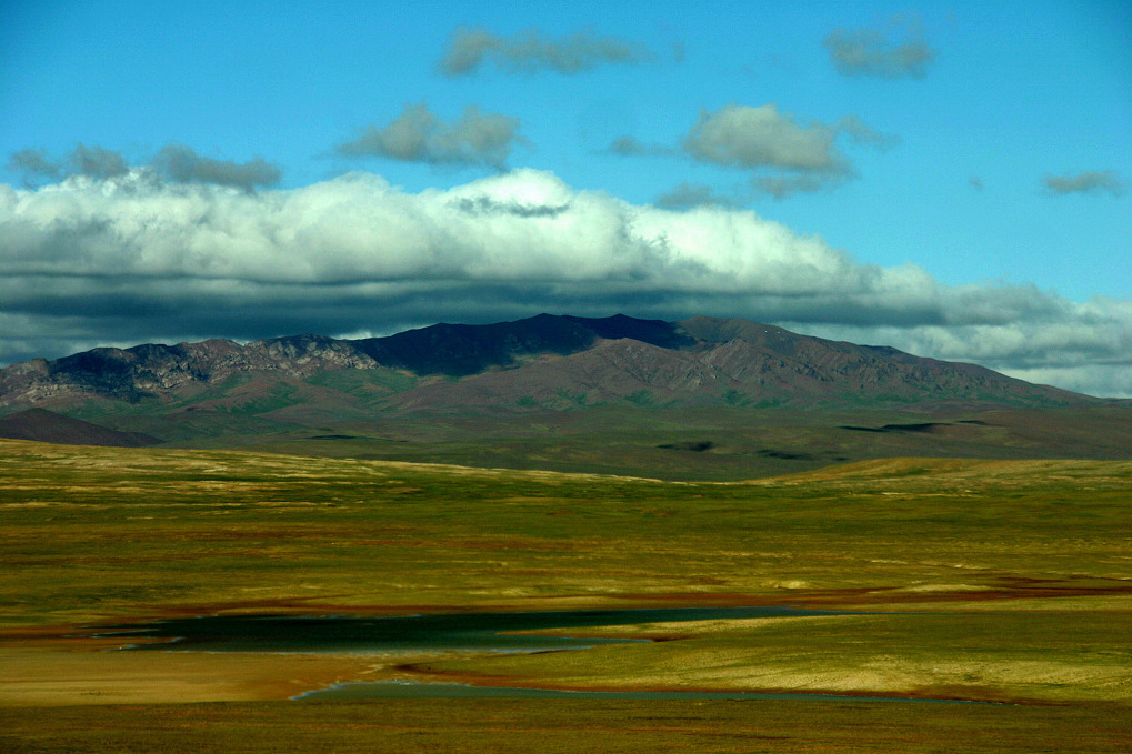
Image

Image of Qinghai Hoh Xil

© 始见, CC BY 2.5 cn Resized from original.

World Heritage Research

Discover scientific research and academic studies that deepen our understanding of Qinghai Hoh Xil from its history and significance to its conservation, management, and contemporary challenges.

  • Extracting water body data based on SDWI and threshold segmentation: A case study in permafrost area surrounding Salt Lake in Hoh Xil, Qinghai-Tibet Plateau, China

    Researchers demonstrate that the Sentinel-1 dual-polarized water index (SDWI), combined with threshold segmentation, is an effective and efficient method for extracting water body data in permafrost areas, particularly under cloudy conditions. Using SAR imagery from 22 August 2022, the study successfully mapped the Hoh Xil Salt Lake and its surrounding lakes on China's Qinghai-Tibet Plateau (QTP), where optical remote sensing was hindered by clouds. The findings highlight SDWI's superiority over single-polarized VV or VH images, offering a robust alternative for large-scale water monitoring in fragile ecosystems like the QTP. This approach mitigates cloud-related errors and supports environmental impact prediction and disaster mitigation efforts.

    Du, Q., Li, G., Chen, D., Qi, S., Zhou, Y., Wang, F., & Cao, Y. (2023). Extracting water body data based on SDWI and threshold segmentation: A case study in permafrost area surrounding Salt Lake in Hoh Xil, Qinghai-Tibet Plateau, China. Research in Cold and Arid Regions, 15(4), 202–209. https://doi.org/10.1016/j.rcar.2023.08.002

    View Publication Record | Read Publication
  • Permafrost characteristics and potential influencing factors in the lake regions of Hoh Xil, Qinghai-Tibet Plateau

    Research on permafrost around large alpine lakes in the Hoh Xil region of the Qinghai-Tibet Plateau reveals that these lakes have only a marginal thermal effect on surrounding permafrost, with cold permafrost extensively developed and ground temperatures below −1.0℃. The study found significant differences in ground temperature between boreholes within and outside lake basins, attributing this to high soil water content. Latent heat effects play a crucial role in buffering permafrost temperature increases under climate warming, while salinity weakens thermal erosion effects. The findings suggest that permafrost thermal regimes are influenced by both altitude and soil water content, providing insights into the interaction between frozen ground, lakes, and the atmosphere.

    Zhang, Y., Zhao, L., Xie, C., Wu, T., Wu, X., Yang, G., Yang, S., Wang, W., Pang, Q., Liu, G., Zou, D., Hu, G., Wang, C., & Liu, S. (2023). Permafrost characteristics and potential influencing factors in the lake regions of Hoh Xil, Qinghai-Tibet Plateau. Geoderma, 437, 116572. https://doi.org/10.1016/j.geoderma.2023.116572

    View Publication Record | Read Publication
  • Do Protected Areas Improve Ecosystem Services? A Case Study of Hoh Xil Nature Reserve in Qinghai-Tibetan Plateau

    Protected areas (PAs) significantly enhance ecosystem services, as demonstrated by a case study of the Hoh Xil Nature Reserve (HXNR) on China's Qinghai-Tibetan Plateau. The research found that HXNR's ecosystem service value (ESV) increased markedly after its designation as protected, contrasting with nearby non-protected areas where ESV declined due to urban expansion and desertification. Hotspot analysis revealed that HXNR's core zones were particularly effective in preserving ecosystem services. The study used remote sensing data, a modified benefit transfer method adjusted with NDVI, and hotspot analysis to compare ESV changes between 1980 and 2018. These findings underscore the critical role of PAs in mitigating environmental degradation and sustaining ecological benefits.

    Zeng, J., Chen, T., Yao, X., & Chen, W. (2020). Do Protected Areas Improve Ecosystem Services? A Case Study of Hoh Xil Nature Reserve in Qinghai-Tibetan Plateau. Remote Sensing, 12(3), 471. https://doi.org/10.3390/rs12030471

    View Publication Record | Read Publication
  • Map and Quantify the Ground Deformation Around Salt Lake in Hoh Xil, Qinghai-Tibet Plateau Using Time-Series InSAR From 2006 to 2018

    Significant ground deformation around the Salt Lake in Qinghai Hoh Xil, Qinghai-Tibet Plateau, was detected using time-series InSAR from 2006 to 2018. Before the 2011 outburst of Zhuonai Lake, deformation rates were minimal (-5 to 5 mm/year). However, post-2014, deformation intensified dramatically, reaching up to -25 mm/year by 2018, correlating with rapid lake expansion and rising water levels. The study employed ENVISAT and Sentinel-1A SAR data, utilizing distributed scatterers and a temperature-related linear deformation model to quantify permafrost instability. Findings underscore the potential hazards of permafrost melting in this region, highlighting time-series InSAR as a critical tool for monitoring environmental changes.

    Zhang, Z., Wang, M., Liu, X., Wang, C., & Zhang, H. (2021). Map and Quantify the Ground Deformation Around Salt Lake in Hoh Xil, Qinghai-Tibet Plateau Using Time-Series InSAR From 2006 to 2018. IEEE Journal of Selected Topics in Applied Earth Observations and Remote Sensing, 14, 858–869. https://doi.org/10.1109/jstars.2020.3031893

    View Publication Record | Read Publication
  • Bacterial community in cold and alkaline environments of Hoh Xil basin in Qinghai–Tibet Plateau and isolation of potential sources of microbiota

    Research on the bacterial communities in the Hoh Xil basin, Qinghai-Tibet Plateau, reveals distinct microbial diversity across cold and alkaline environments. The study identified 10 strains of bacteria, predominantly Pseudomonas (90.8%), with one strain, k9, showing optimal growth at high pH (10.0) and low temperature (5°C), along with the ability to produce multiple extracellular enzymes under alkaline and cold conditions. This suggests potential psychrophilic and alkaliphilic bacteria with biotechnological applications. The study used both culture-dependent and independent methods to analyze desert soil, saline-alkali land, saline-alkali wetland, and soda lake sediment samples, highlighting the unique microbial adaptations in this extreme environment.

    Xing, R., Gao, Q.-b., Zhang, F.-q., Wang, J.-l., & Chen, S.-l. (2019). Bacterial community in cold and alkaline environments of Hoh Xil basin in Qinghai–Tibet Plateau and isolation of potential sources of microbiota. Annals of Microbiology, 69(5), 567–576. https://doi.org/10.1007/s13213-019-01447-w

    View Publication Record | Read Publication
  • Prevalence and Parasite Composition of Gastrointestinal Parasites in the Endangered Tibetan Antelope (Pantholops Hodgsonii) from the Calving Ground of Hoh Xil Nature World Heritage Site, Qinghai, China

    A comprehensive survey of gastrointestinal parasites in the endangered Tibetan antelope (Pantholops hodgsonii) on its calving grounds at Qinghai Hoh Xil revealed widespread and diverse parasite infections. The study found that 93% of fecal samples tested positive for nematodes, 36% for cestodes, and an astonishing 99% for coccidian oocysts, with an average of 3.4 parasite species per individual. Coinfections involving five parasite genera were detected in 19% of samples, highlighting the complex parasitic burden faced by this vulnerable species. The high prevalence of Trichostrongylus, Marshallagia, and Eimeria infections suggests these parasites pose significant long-term risks, particularly as climate change increases warmth and moisture in the region. Researchers analyzed 238 fecal samples collected in July 2018 using flotation techniques to identify eggs, oocysts, and nematode larvae, providing critical baseline data for monitoring future health trends.

    Cao, Y., Yang, Y., Duszynski, D. W., Zhu, Y., Shang, G., Hou, C., Zhang, T., & Bian, J. (2020). PREVALENCE AND PARASITE COMPOSITION OF GASTROINTESTINAL PARASITES IN THE ENDANGERED TIBETAN ANTELOPE (PANTHOLOPS HODGSONII) FROM THE CALVING GROUND OF HOH XIL NATURE WORLD HERITAGE SITE, QINGHAI, CHINA. Journal of Wildlife Diseases, 56(2), 372. https://doi.org/10.7589/2019-05-142

    View Publication Record | Read Publication
  • A wild yak survey in Chang Tang of Tibet Autonomous Region and Hoh Xil of Qinghai Province

    Recent surveys reveal that the population of wild yaks (Bos grunniens) in the Qinghai-Tibet Plateau has increased since the 1990s, with estimates ranging from 11,222 to 21,072 individuals in Chang Tang, Tibet, and 659 to 1,793 in Hoh Xil, Qinghai. Despite this growth, the distribution area of wild yaks is shrinking due to climate change and intensifying human activities. The study, conducted between 2012 and 2014 using field data and published literature, highlights the need for stronger conservation actions to protect this endemic species in one of China's most ecologically significant regions.

    Hu, Y., Li, W., Jiang, Z., Liu, W., Liang, J., Lin, Y., Huang, Z., Qin, H., Jin, K., & Hu, H. (2018). A wild yak survey in Chang Tang of Tibet Autonomous Region and Hoh Xil of Qinghai Province. Biodiversity Science, 26(2), 185–190. https://doi.org/10.17520/biods.2017340

    View Publication Record | Read Publication

About World Heritage Explorer

World Heritage Explorer is an independent educational project designed to uncover and share the richness of our world’s cultural and natural heritage. Dive into detailed site profiles, immersive imagery, interactive maps, and tools that help you explore UNESCO World Heritage Sites across the globe. Drawing extensively on open data sources, the project delivers authoritative, well-structured information for learners, educators, travelers, and younger explorers alike.

Learn more about the project

Nearby World Heritage Sites

Mogao Caves
568 km — China
Historic Ensemble of the Potala Palace, Lhasa
648 km — China
Khangchendzonga National Park
930 km — India
Moidams – the Mound-Burial System of the Ahom Dynasty
967 km — India
Manas Wildlife Sanctuary
972 km — India
Flag of China

China and the World Heritage Convention

State Party since: December 12, 1985

Status: Ratification

Mandates to the World Heritage Committee: 1991-1997, 1999-2005, 2007-2011, 2017-2021

Total of Mandate Years: 20

Total of Mandates: 4

WHC Electoral Group: IV (Asia/Pacific)

Learn more about China

Weather at the World Heritage Site

Last updated: September 8, 2026

Portions of the page Qinghai Hoh Xil are based on data from UNESCO — World Heritage List Dataset and on text from the Wikipedia article Hoh Xil, licensed under CC BY-SA 4.0. Changes made. Additional original content by World Heritage Explorer (WHE), licensed under CC BY-SA 4.0. WHE is not affiliated with UNESCO or the World Heritage Committee. Legal Notice. Privacy Policy.

Open Data for an Open World