World Heritage Identification Number: 1595
World Heritage since: 2025
Category: Cultural Heritage
WHE Type: Archaeological Sites
Transboundary Heritage: No
Endangered Heritage: No
Country: 🇯🇲 Jamaica
Continent: Americas
UNESCO World Region: Latin America and the Caribbean
Map
The Archaeological Ensemble of 17th Century Port Royal: A Submerged Colonial Gem
The Archaeological Ensemble of 17th Century Port Royal, inscribed as a UNESCO World Heritage Site in 2025, offers a unique glimpse into the history and culture of colonial England's presence in the Caribbean. Located at the mouth of Kingston Harbour in southeastern Jamaica, this once thriving port city provides valuable insights into urban colonial life during the 17th century.
More to come…UNESCO Description of the World Heritage Site
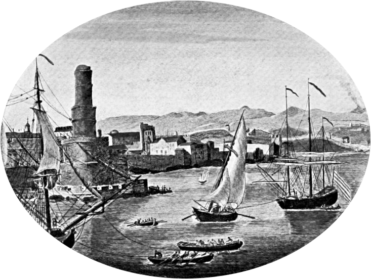
The town of Port Royal is located at the mouth of Kingston Harbour in southeastern Jamaica. It was a major 17th-century English port city. A devastating earthquake in 1692 submerged much of the town under water and sand. Today, its terrestrial and underwater remains offer rare insights into urban colonial life. Once a key hub for transatlantic trade—including the trade of enslaved Africans—Port Royal featured a deep-water port and six defensive forts, some now submerged. Archaeological evidence reveals a well-preserved layout of residential, religious, and administrative buildings, serving as a distinctive marker of British colonial presence in the Caribbean.
UNESCO Justification of the World Heritage Site
Criterion (iv): The Archaeological Ensemble of 17th Century Port Royal is an exceptional illustration of an early English colonial settlement during the period of European expansion and rivalry, which is a significant stage in the history of the Americas. With its deep natural harbour and strategic location in the centre of the Spanish Main, Port Royal developed in just thirty-seven years from a colonial frontier settlement to a pivotal 17th-century port town, documented as the most important English settlement in the Western Hemisphere. The global network of trade that converged here is reflected in the rich volume of recovered artefacts from as far away as Asia and Europe.
Criterion (vi): The Archaeological Ensemble of 17th Century Port Royal exemplifies England’s decisive role in the trafficking of enslaved Africans to the Americas. The fortifications and infrastructure are tangible evidence of the contribution of enslaved Africans to the rise, growth, and sustainability of Port Royal, as well as to the transfer of knowledge and skills. The 1692 earthquake caused the deaths of many people, making the property a grave site not only for the merchants and the wealthy, but also for the poor and enslaved.
Encyclopedia Record: Port Royal
Port Royal was a town located at the end of the Palisadoes, at the mouth of Kingston Harbour, in southeastern Jamaica. Founded in 1494 by the Spanish, it was once the largest and most prosperous city in the Caribbean, functioning as the centre of shipping and commerce in the Caribbean Sea by the latter half of the 17th century. It was destroyed by an earthquake on 7 June 1692 and its accompanying tsunami, leading to the establishment of Kingston, the capital and the most populated and prosperous city in Jamaica. Severe hurricanes have regularly damaged the area. Another severe earthquake occurred in 1907.Additional Site Details
Area: 27 hectares
Number of Components: 1
(vi) — Directly associated with events or living traditions
Coordinates: 17.9386138889 , -76.8433777778
Image
- Old_Port_Royal_-_Project_Gutenberg_eText_19396.jpg: John Masefield
- derivative work: Beao
