World Heritage Identification Number: 749
World Heritage since: 1996
Category: Natural Heritage
WHE Type: Protected Areas & National Parks
Transboundary Heritage: Yes
Endangered Heritage: No
Country: Benin, Burkina Faso, Niger
Continent: Africa
UNESCO World Region: Africa
Map
W-Arly-Pendjari Complex: A Transboundary Refuge for West African Wildlife
The W-Arly-Pendjari Complex (WAP Complex) is a significant transnational UNESCO World Heritage Site, spanning across the nations of Benin, Burkina Faso, and Niger. Inscribed in 1996, this expansive conservation area encompasses a vast swath of the Sudano-Sahelian savannah, making it one of the largest and most crucial undisturbed regions within the West African savannah belt.
More to come…UNESCO Description of the World Heritage Site
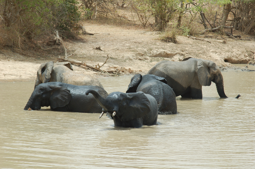
This transnational extension (Benin, Burkina Faso) to the W National Park of Niger, inscribed in 1996 on the World Heritage List, cover a major expanse of intact Sudano-Sahelian savannah, with vegetation types including grasslands, shrub lands, wooded savannah and extensive gallery forests. It includes the largest and most important continuum of terrestrial, semi-aquatic and aquatic ecosystems in the West African savannah belt. The property is a refuge for wildlife species that have disappeared elsewhere in West Africa or are highly threatened. It is home to the largest population of elephants in West Africa and most of the large mammals typical of the region, such as the African Manatee, cheetah, lion and leopard. It also harbours the only viable population of lions in the region.
UNESCO Justification of the World Heritage Site
Criterion (ix): Stretching across three countries, W-Arly-Pendjari Complex is the largest and most important continuum of terrestrial, semi-aquatic and aquatic ecosystems in the West African savanna belt. Situated within the Volta River basin it comprises a dynamic system, where the ebb and flow of water with alternating wet and dry seasons creates a rich variety of plant communities and associated fauna. The Complex is a major expanse of intact Sudano-Sahelian savanna, with numerous and diverse types of vegetation such as grassland, shrub, wooded savannah, open forests and extensive gallery and riparian forests as well as the rare semi-deciduous forest of Bondjagou within Pendjari National Park. The long-term effects of fire linked to human occupation, perhaps dating back some 50,000 years, have shaped the vegetation of the property, and the continued traditional use of fire maintains the diversity of vegetation types, which in turn provide habitat for the property’s characteristic wildlife.
Criterion (x): The property and the broader landscape are a refuge for species of fauna that have disappeared or are highly threatened in most of the rest of West Africa. The W-Arly-Pendjari Complex is particularly crucial to the conservation of the last healthy populations of mammals belonging to the Sahelian and Sudanian domains. The Complex includes the largest and most ecologically secure elephant population in West Africa, representing 85% of the region's savanna elephants. It also protects almost the complete assemblage of characteristic flora and fauna, providing crucial habitat for most of the large mammal species typical of West Africa, such as African Manatee, Cheetah, Lion, Leopard, African Wild Dog and Topi Antelope. It harbours the only viable population of lion in the area and probably the only population of cheetah in West Africa. The site exhibits particularly high levels of endemism among fish species and is home to seven of the nine endemic fish species reported in the Volta Basin.
Encyclopedia Record: W-Arly-Pendjari Complex
W-Arly-Pendjari Complex, also known as the "WAP Complex", is a transboundary Natural UNESCO World Heritage Site in Benin, Burkina Faso and Niger covering:Arli National Park in Burkina Faso Pendjari National Park in Benin W National Park, shared by the three countriesAdditional Site Details
Area: 1,714,831 hectares
Number of Components: 3
(x) — Contains most important habitats for biodiversity
Coordinates: 11.8841666667 , 2.4877777778
IUCN World Heritage Outlook
The 2025 Conservation Outlook on W-Arly-Pendjari Complex reports the following assessment:
Source: International Union for Conservation of Nature (IUCN) · View assessment
Image
© Roland Hunziker https://www.flickr.com/photos/rolandh/, CC BY-SA 2.0 Resized from original. (This derivative is under the same CC BY-SA license.)