World Heritage Identification Number: 138
World Heritage since: 1980
Category: Cultural Heritage
WHE Type: Archaeological Sites
Transboundary Heritage: No
Endangered Heritage: No
Country: 🇵🇰 Pakistan
Continent: Asia
UNESCO World Region: Asia and the Pacific
Map
The Archaeological Ruins at Moenjodaro: A Window into the Indus Valley Civilization
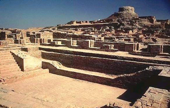
The Archaeological Ruins at Moenjodaro, located in the Larkana District of Sindh, Pakistan, offer a unique glimpse into one of the world's earliest urban civilizations - the Indus Valley Civilization. This vast archaeological site, dating back to around 2500 BCE, is a testament to the advanced urban planning, architectural prowess, and cultural sophistication of its inhabitants.
More to come…UNESCO Description of the World Heritage Site
The ruins of the huge city of Moenjodaro – built entirely of unbaked brick in the 3rd millennium B.C. – lie in the Indus valley. The acropolis, set on high embankments, the ramparts, and the lower town, which is laid out according to strict rules, provide evidence of an early system of town planning.
UNESCO Justification of the World Heritage Site
Criterion (ii): The Archaeological Ruins at Moenjodaro comprise the most ancient planned city on the Indian subcontinent, and exerted great influence on the subsequent urbanization of human settlement in the Indian peninsular.
Criterion (iii): As the most ancient and best preserved urban ruin in the Indus Valley dating back to the 3rd millennium BC, Moenjodaro bears exceptional testimony to the Indus civilization.
Encyclopedia Record: Mohenjo-daro
Mohenjo-daro is an archaeological site in Larkana District, Sindh, Pakistan. Built c. 2500 BCE, it was one of the largest settlements of the ancient Indus Valley Civilisation, and one of the world's earliest major cities, contemporaneous with the civilisations of ancient Egypt, Mesopotamia, Minoan Crete, and Norte Chico.Additional Site Details
Area: 240 hectares
Number of Components: 1
(iii) — Unique or exceptional testimony to a cultural tradition
Coordinates: 27.32916667 , 68.13888889
World Heritage Research
Discover scientific research and academic studies that deepen our understanding of Archaeological Ruins at Moenjodaro from its history and significance to its conservation, management, and contemporary challenges.
-
Inequality declined in the Bronze Age city of Mohenjo-daro
A new analysis of residence areas at the Bronze Age city of Mohenjo-daro, part of the UNESCO-listed Archaeological Ruins at Moenjodaro, reveals that economic inequality declined over time despite urban growth. Contrary to traditional assumptions linking urbanism with increased stratification, researchers calculated Gini coefficients using early excavation data and found they decreased as the city prospered and its street plan developed. This suggests governance may have played a role in limiting inequality, challenging prevailing narratives about ancient urban societies.
Green, A. S., Alam, I., & Petrie, C. (2026). Inequality declined in the Bronze Age city of Mohenjo-daro. Antiquity, 100(413), 1239–1254. https://doi.org/10.15184/aqy.2026.10359
View Publication Record | Read Publication -
Urban Planning of Mohenjo-Daro: A Way forward for Contemporary Sustainable Infrastructure
Ancient urban planning techniques from Mohenjo-Daro, a key city of the Indus Valley Civilization, offer valuable insights for modern sustainable infrastructure. This study reveals that Mohenjo-Daro's advanced architectural strategies can be adapted and revived with innovative approaches to address contemporary developmental challenges. The research employs archival documentation, expert interviews, and literature reviews to analyze historical urban planning practices. By integrating these ancient methods with modern innovations, the findings suggest a pathway for creating sustainable, resilient cities that align with current global emphasis on eco-friendly urban development.
Imdad Rasool, Saima Kalwar, & Wamiq Khan. (2026). Urban Planning of Mohenjo-Daro: A Way forward for Contemporary Sustainable Infrastructure. Research Journal of Social Sciences and Economics Review, 7(2), 36–45. https://doi.org/10.36902/rjsser-vol7-iss2-2026(36-45)
View Publication Record | Read Publication -
An Aayaadi-Based Metrological Analysis of the Mohenjo-daro Bronze Figurine
A metrological analysis of the Mohenjo-daro 'Dancing Girl' figurine reveals potential correlations between its dimensions and the traditional Indian Aayaadi measurement system, suggesting a possible link to the nakshatra Shatataraka. This study marks the first systematic examination of the sculpture's measurements using Aayaadi principles, proposing that further interdisciplinary research is needed to validate this hypothesis. The approach combines metrological analysis with iconographic features, offering new avenues for understanding the cultural and astronomical significance of one of the Indus Valley Civilization's most iconic artifacts.
Ar. Samrat sarode. (2026). An Aayaadi-Based Metrological Analysis of the Mohenjo-daro Bronze Figurine [Zenodo]. https://doi.org/10.5281/ZENODO.21404618
View Publication Record | Read Publication -
Archaeological Evidence for a Standardized Linear Measurement System at Mohenjo-daro:
Archaeological research at Mohenjo-daro reveals that the Indus Civilization employed a standardized linear measurement system, challenging earlier interpretations. The study re-examines the graduated shell scale discovered by Ernest J. H. Mackay, proposing an alternative metrological framework based on the Kishku Angula unit (1⅜ inches or 34.925 mm). This hypothesis was tested against architectural modules, brick dimensions, street and block measurements, and artifacts like the Dancing Girl figurine from Mohenjo-daro and other Indus sites. By integrating comparative metrology, dimensional analysis, and architectural proportional analysis, the research demonstrates a coherent measurement system that aligns with previously documented Harappan standards, advancing our understanding of the civilization's sophistication in town planning and craft production.
sarode, samrat. (2026). Archaeological Evidence for a Standardized Linear Measurement System at Mohenjo-daro: Zenodo. https://doi.org/10.5281/ZENODO.22040551
View Publication Record | Read Publication -
Inventing Urban Public Space: Morphogenesis and Energized Crowding in Mohenjo-Daro
Mohenjo-Daro, one of the earliest Indus cities (2600–1900 BCE), exemplifies how urban morphology evolved to sustain dense public life while managing social interactions. Contrary to its reputation as a 'planned' city, this study reveals an adaptive, experimental process that balanced energized crowding with the challenges of everyday encounters among strangers. By merging archaeology and urban design theory, researchers mapped the city's street and laneway networks to uncover their spatial logic and generative forces, shedding light on the dynamic interplay between planned and unplanned urban development, cities and states, and the essence of urbanity.
Dovey, K., & Smith, Michael E. (2025). Inventing Urban Public Space: Morphogenesis and Energized Crowding in Mohenjo-Daro. Journal of Urban Archaeology, 12(1), 53–69. https://doi.org/10.1484/j.jua.5.151427
View Publication Record | Read Publication -
The Materiality of Foresight: Grid, Granaries, and the Planned Metropolis of Mohenjo-Daro
Mohenjo-Daro, an ancient Indus Valley Civilization urban center, exemplifies advanced urban planning and foresight through its orthogonal grid system and monumental granaries. These structures, characterized by standardized brick sizes, elaborate drainage systems, and strategically located public buildings like the Great Bath, suggest a deliberate long-term vision for societal resilience, resource management, and communal living. The study posits that these material structures are active embodiments of collective foresight, enabling sustained prosperity and stability while encoding strategies for anticipating future challenges such as food security and public health. By examining the functional and symbolic dimensions of the grid and granaries, this research offers profound insights into pre-modern governance and environmental adaptation.
Revista, Z., & CHEMISTRY, 10. (2025). The Materiality of Foresight: Grid, Granaries, and the Planned Metropolis of Mohenjo-Daro. Zenodo. https://doi.org/10.5281/ZENODO.17748800
View Publication Record | Read Publication -
Rapid Assessment of 2022 Floods around the UNESCO Site of Mohenjo-Daro in Pakistan by Using Sentinel and Planet Labs Missions
A combination of Sentinel-1 radar, mid-resolution Sentinel-2, and Planet Labs imagery enabled precise mapping of flood-affected areas around the UNESCO World Heritage Site of Mohenjo-Daro during Pakistan's 2022 floods. While the site itself remained largely intact, surrounding landscapes sustained significant damage from heavy rains. This multi-sensor approach demonstrated its potential for near-real-time assessments, offering critical data to guide recovery strategies and inform heritage management decisions. The study highlights how advanced remote sensing can effectively support vulnerable cultural sites facing natural hazards.
Hegyi, A., & Agapiou, A. (2023). Rapid Assessment of 2022 Floods around the UNESCO Site of Mohenjo-Daro in Pakistan by Using Sentinel and Planet Labs Missions. Sustainability, 15(3), 2084. https://doi.org/10.3390/su15032084
View Publication Record | Read Publication