World Heritage Identification Number: 149
World Heritage since: 1981
Category: Cultural Heritage
WHE Type: Archaeological Sites
Transboundary Heritage: No
Endangered Heritage: No
Country: 🇬🇹 Guatemala
Continent: Americas
UNESCO World Region: Latin America and the Caribbean
Map
Archaeological Park and Ruins of Quirigua: A Window into Ancient Maya Civilization
The Archaeological Park and Ruins of Quirigua, located in the department of Izabal in southeastern Guatemala, offer a captivating glimpse into the rich cultural heritage of the ancient Maya civilization. This medium-sized site, spanning roughly 3 square kilometers (1.2 square miles), is situated along the lower Motagua River, with the ceremonial center approximately 1 kilometer (0.6 miles) from the river's north bank.
More to come…UNESCO Description of the World Heritage Site
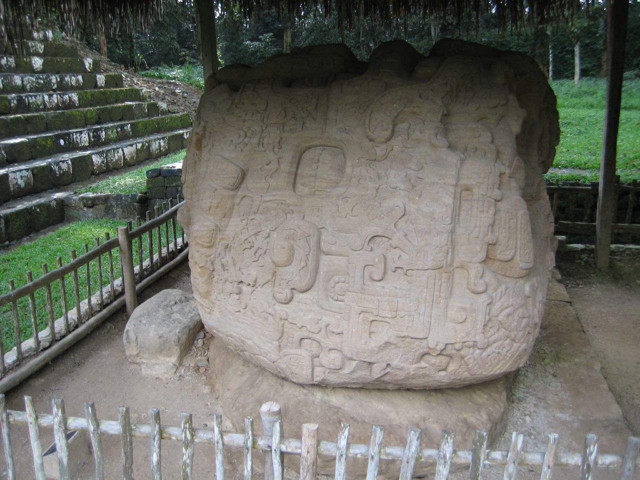
Inhabited since the 2nd century A.D., Quirigua had become during the reign of Cauac Sky (723–84) the capital of an autonomous and prosperous state. The ruins of Quirigua contain some outstanding 8th-century monuments and an impressive series of carved stelae and sculpted calendars that constitute an essential source for the study of Mayan civilization.
UNESCO Justification of the World Heritage Site
Criterion (i) : The monuments of the Archaeological Park and Ruins of Quirigua are an outstanding example and the largest corpus of Maya art masterpieces. They are an advanced representation of artistic skill by their sculptors and the meaning and beauty of each piece has survived the passing of this civilization, making them universal masterpieces.
Criterion (ii): The monuments of the Archaeological Park and Ruins of Quirigua were carved during the Classical Period dating from 250 AD to 900 AD. Between the times of 700 AD to 850 AD arose and flourished a style of art known as The school of Motagua. This style is seen in the monuments of Quirigua and which in turn had a strong influence over the art production in the Maya area of Copán (Honduras) and Belize.
Criterion (iv) : The Archaeological Park and Ruins of Quirigua contain some outstanding 8th-century monuments and an impressive series of carved stelae and sculpted calendars that constitute an essential source for the study of Mayan civilization. The ruins of Quirigua retain an impressive series of stelae and sculpted calendars, partially deciphered, which constitute a remarkable and unique source of the history of the social, political and economic events of the Mayan civilization. The zoomorphic and anthropomorphic sculptures are among the most attractive pre-Columbian works known.
Encyclopedia Record: Quiriguá
Quiriguá is an ancient Maya archaeological site in the department of Izabal in south-eastern Guatemala. It is a medium-sized site covering approximately 3 square kilometres (1.2 sq mi) along the lower Motagua River, with the ceremonial center about 1 km (0.6 mi) from the north bank. During the Maya Classic Period (AD 200–900), Quiriguá was situated at the juncture of several important trade routes. The site was occupied by 200, construction on the acropolis had begun by about 550, and an explosion of grander construction started in the 8th century. All construction had halted by about 850, except for a brief period of reoccupation in the Early Postclassic. Quiriguá shares its architectural and sculptural styles with the nearby Classic Period city of Copán, with whose history it is closely entwined.Additional Site Details
Area: 34 hectares
Number of Components: 1
(ii) — Significant interchange of human values
(iv) — Outstanding example of a type of building or landscape
Coordinates: 15.27059 , -89.04025