World Heritage Identification Number: 764
World Heritage since: 1996
Category: Natural Heritage
WHE Type: Natural Landscapes & Geographic Features
Transboundary Heritage: No
Endangered Heritage: No
Country: 🇧🇿 Belize
Continent: Americas
UNESCO World Region: Latin America and the Caribbean
Map
The Belize Barrier Reef Reserve System: A Natural Marvel of the Northern Hemisphere
The Belize Barrier Reef Reserve System, inscribed as a UNESCO World Heritage Site in 1996, showcases an exceptional natural system that spans the coastline of Belize. This remarkable ecosystem encompasses the largest barrier reef in the northern hemisphere, offshore atolls, numerous sand cays, expansive mangrove forests, coastal lagoons, and estuaries. The reserve system offers a unique glimpse into the evolutionary history of reef development and serves as a crucial habitat for various endangered species, such as marine turtles, manatees, and the American marine crocodile.
More to come…UNESCO Description of the World Heritage Site
The coastal area of Belize is an outstanding natural system consisting of the largest barrier reef in the northern hemisphere, offshore atolls, several hundred sand cays, mangrove forests, coastal lagoons and estuaries. The system’s seven sites illustrate the evolutionary history of reef development and are a significant habitat for threatened species, including marine turtles, manatees and the American marine crocodile.
UNESCO Justification of the World Heritage Site
Criterion (vii): The Belize Barrier Reef Reserve System (BBRRS) is unique in the world for its array of reef types contained in a relatively small area. As the longest barrier reef in the Northern and Western Hemispheres and distinctive on account of its size, array of reef types and the luxuriance of corals thriving in a pristine condition it provides a classic example of the evolutionary history of reefs and reef systems. The rise and fall of sea level over the millennia, coupled with natural karst topography and clear waters, results in a diverse submarine seascape of patch reefs, fringing reefs, faros, pinnacle reefs, barrier reefs as well as off-shelf atolls, rare deep water coral reefs and other unique geological features such as the Blue Hole and Rocky Point where the barrier reef touches the shore. The spectacular picturesque natural setting of brilliant white sand cayes and verdant green mangrove cayes is in dramatic contrast to the surrounding azure waters.
Criteria (ix): Illustrating a classic example of reef types, including fringing, barrier and atoll reef types, the BBRRS contains an intact ecosystem gradient ranging from the terrestrial to the deep ocean. Including littoral, wetland, and mangrove ecosystems, to seagrass beds interspersed with lagoonal reefs, to the outer barrier reef platform and oceanic atolls, this ecological gradient provides for a full complement of life-cycle needs, supporting critical spawning, nesting, foraging, and nursery ecosystem functions. Maintaining these ecological and biological processes ensures robust and resilient reefs, which are them selves one of the world’s most ancient and diverse ecosystems.
Criteria (x): Home to a diverse array of top predators, on land, sea and in the air, the jaguars of Bacalar Chico, the great hammerheads of the Blue Hole, and the ospreys of Glovers Reef are a testament to the property’s importance and its ecological integrity. A total of 178 terrestrial plants and 246 taxa of marine flora have been described from the area while over 500 species of fish, 65 scleractinian corals, 45 hydroids and 350 molluscs have been recorded. Numerous endangered species are protected within the boundaries of the BBRRS including; the West Indian manatee, the American crocodile and three species of sea turtle. The property also provides valuable habitat for three species of groupers, and the red-footed booby. The BBRRS is also home to endemic species including several Yucatan birds, island lizards, several fishes, tunicates, and sponges, making it an area with one of the highest levels of marine biodiversity in the Atlantic.
Encyclopedia Record: Belize Barrier Reef
The Belize Barrier Reef is a series of coral reefs straddling the coast of Belize, roughly 300 metres (980 ft) offshore in the north and 40 kilometres (25 mi) in the south within the country limits. The Belize Barrier Reef is a 300-kilometre (190 mi) long section of the 900-kilometre (560 mi) Mesoamerican Barrier Reef System, which is continuous from Cancún on the north-eastern tip of the Yucatán Peninsula through the Riviera Maya and down to Honduras, making it the second largest coral reef system in the world after the Great Barrier Reef in Australia. It is Belize's top tourist destination, popular for scuba diving and snorkeling and attracting almost half of its 260,000 visitors. It is also vital to the country's fishing industry.Additional Site Details
Area: 96,300 hectares
Number of Components: 7
(ix) — Outstanding example representing ecological and biological processes
(x) — Contains most important habitats for biodiversity
Coordinates: 17.190549 , -87.846213
IUCN World Heritage Outlook
The 2025 Conservation Outlook on Belize Barrier Reef Reserve System reports the following assessment:
Source: International Union for Conservation of Nature (IUCN) · View assessment
Image
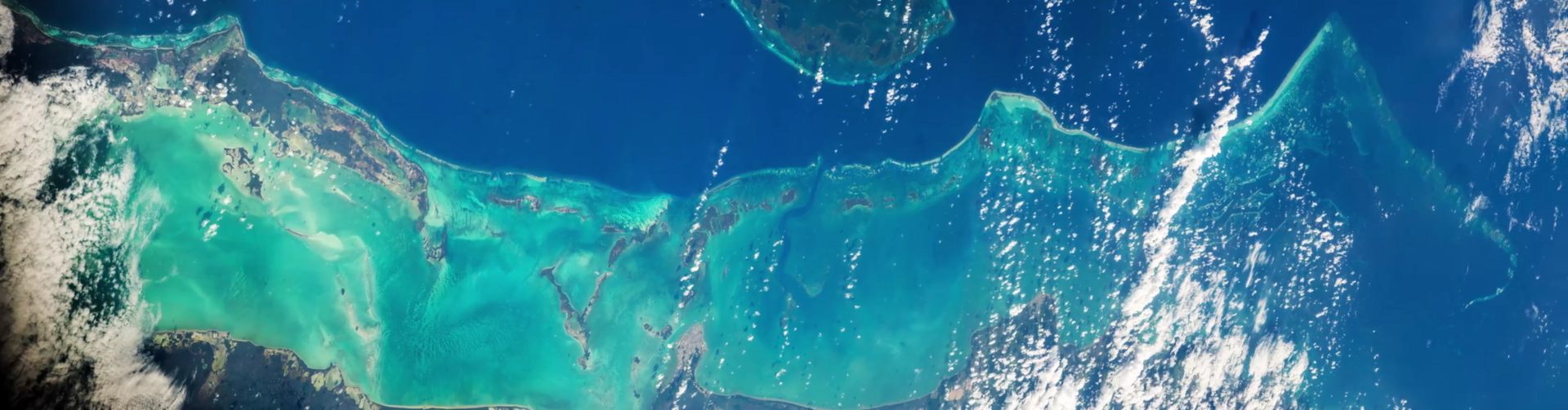
Jeff Williams (NASA), Public domain
World Heritage Research
Discover scientific research and academic studies that deepen our understanding of Belize Barrier Reef Reserve System from its history and significance to its conservation, management, and contemporary challenges.
-
A Ten-Year Record Shows Warming Inside the Belize Barrier Reef Lagoon
A decade-long temperature record from the Belize Barrier Reef Reserve System reveals a steady increase in sea temperatures within its lagoon habitat between 2004 and 2014. This finding suggests that the unique biogeographic region, home to several endemic species, is experiencing significant warming—potentially due to global climate change—that could have long-term adverse effects on its marine biodiversity. The study analyzed in situ data collected from a coral reef offshore of Wee Wee Cay within the South Water Cay Marine Reserve, providing critical insights into how lagoon ecosystems differ from deeper offshore areas and highlighting their vulnerability to rising temperatures.
Lobel, P. S., & Lobel, L. K. (2024). A Ten-Year Record Shows Warming Inside the Belize Barrier Reef Lagoon. Diversity, 16(1), 57. https://doi.org/10.3390/d16010057
View Publication Record | Read Publication -
Modeled Impacts of LULC and Climate Change Predictions on the Hydrologic Regime in Belize
Future water quality in Belize could improve due to projected decreases in precipitation from climate change, which may reduce runoff. However, conservation-focused land use and land cover (LULC) scenarios show a 28% lower increase in runoff compared to business-as-usual and development scenarios by 2090, indicating that land management strategies can mitigate negative impacts on water quality. The study integrated Coupled Model Intercomparison Project phase 6 (CMIP-6) climate scenarios with hydrologic modeling to estimate runoff as a proxy for water quality, revealing a positive relationship between precipitation and runoff. Southern watersheds are expected to experience greater decreases in rainfall and runoff than northern ones, highlighting regional variations in vulnerability.
Martín-Arias, V., Evans, C., Griffin, R., Cherrington, E. A., Lee, C. M., Mishra, D. R., Gomez, N. A., Rosado, A., Callejas, I. A., Jay, J. A., & Rosado, S. (2022). Modeled Impacts of LULC and Climate Change Predictions on the Hydrologic Regime in Belize. Frontiers in Environmental Science, 10. https://doi.org/10.3389/fenvs.2022.848085
View Publication Record | Read Publication -
Use of public Earth observation data for tracking progress in sustainable management of coastal forest ecosystems in Belize, Central America
A study using public Earth observation data reveals that the Belize Barrier Reef Reserve System (BBRRS) experienced significantly lower mangrove loss compared to areas outside the reserve. Between 1996 and 2017, the BBRRS lost approximately 89 hectares of mangroves, while outside the BBRRS, the loss was 2703 hectares during the same period. Nationwide, Belize's overall mangrove cover declined by 5.4% over 36 years, from 76,250 hectares in 1980 to 72,169 hectares in 2017. The research highlights that almost 75% of the mangrove loss outside the BBRRS was concentrated in zones associated with tourism infrastructure. This study demonstrates the effectiveness of Earth observation systems in tracking progress toward Sustainable Development Goal (SDG) Targets 15.2 and 14.2, providing a use case for monitoring changes in baseline data to support sustainable management of coastal ecosystems.
Cherrington, E. A., Griffin, R. E., Anderson, E. R., Hernandez Sandoval, B. E., Flores-Anderson, A. I., Muench, R. E., Markert, K. N., Adams, E. C., Limaye, A. S., & Irwin, D. E. (2020). Use of public Earth observation data for tracking progress in sustainable management of coastal forest ecosystems in Belize, Central America. Remote Sensing of Environment, 245, 111798. https://doi.org/10.1016/j.rse.2020.111798
View Publication Record | Read Publication -
Land Cover Changes on Ambergris Caye, Belize: A Case Study of Unregulated Tourism Development
Between 2000 and 2017, Ambergris Caye, Belize—a key tourist destination within the UNESCO-listed Belize Barrier Reef Reserve System—experienced a significant 10.85% decline in vegetation cover, alongside a 39% increase in urban and barren land, driven by rapid, unregulated development. Using Landsat satellite imagery and unsupervised classification methods, researchers quantified these changes, revealing an annual forest loss rate of 0.67%. This baseline study highlights the environmental impacts of tourism-driven growth on tropical ecosystems, offering critical data for conservation and sustainable planning efforts in the region.
Sweetman, B. M., Cissell, J. R., Rhine, S., & Steinberg, M. K. (2018). Land Cover Changes on Ambergris Caye, Belize: A Case Study of Unregulated Tourism Development. The Professional Geographer, 71(1), 123–134. https://doi.org/10.1080/00330124.2018.1501710
View Publication Record | Read Publication