World Heritage Identification Number: 1174
World Heritage since: 2018
Category: Mixed Cultural Heritage and Natural Heritage
WHE Type: Protected Areas & National Parks
Transboundary Heritage: No
Endangered Heritage: No
Country: 🇨🇴 Colombia
Continent: Americas
UNESCO World Region: Latin America and the Caribbean
Map
Chiribiquete National Park: A Tropical Rainforest Sanctuary
Chiribiquete National Park, colloquially known as "The Maloca of the Jaguar," is a vast and pristine expanse of tropical rainforest located in the southwestern region of Colombia. Established in 1989 and expanded twice since, it now encompasses approximately 43,000 square kilometers, making it the largest tropical rainforest national park globally. This expansive park serves as a crucial biodiversity hotspot, bridging four distinct biogeographical provinces: Amazon, Andes, Orinoco, and Guyana.
More to come…UNESCO Description of the World Heritage Site
Chiribiquete National Park, the largest protected area in Colombia, is the confluence point of four biogeographical provinces: Amazon, Andes, Orinoco and Guyana. As such, the National Park guarantees the connectivity and preservation of the biodiversity of these provinces, constituting itself as an interaction scenario in which flora and fauna diversity and endemism have flourished. One of the defining features of Chiribiquete is the presence of tepees (table-top mountains), sheer-sided sandstone plateaux that outstand in the forest and result in dramatic scenery that is reinforced by its remoteness, inaccessibility and exceptional conservation. Over 75,000 figures have been made by indigenous people on the walls of the 60 rock shelters from 20,000 BCE, and are still made nowadays by the uncontacted peoples protected by the National Park. These paintings depict hunting scenes, battles, dances and ceremonies, as well as fauna and flora species, with a particular the worship of the jaguar, a symbol of power and fertility. The indigenous communities, which are not directly present on the site, consider Chiribiquete as a sacred place that cannot be visited and that should be preserved unaltered.
UNESCO Justification of the World Heritage Site
Criterion (iii): The rock art sites of Chiribiquete hold an exceptional testimony, by the large number of painted rock shelters around the foot of rare tepui rock formations, by the diversity of motifs, which are often realistic, and by the chronological depth and persistence up to the present-day of the purported frequentation of the sites by isolated communities. The first inhabitants of Amazonia practised their art on the rock walls of Chiribiquete, and these paintings constitute an exceptional testimony of their vision of the world. Chiribiquete is even today considered to be of mythical importance by several groups and is designated the “Great Home of the Animals”.
Criterion (ix): The property, due to its unique location in the middle of two Pleistocene refuges (Napo and Imeri) and its function as a corridor between three biogeographic provinces (Orinoquia, Guyana, and Amazonia), hosts unique species with distinctive adaptations that are thought to have resulted from its geographical isolation. It is located in the Chiribiquete-Araracuara-Cahuinari Region Centre for Plant Diversity and has been identified as a gap. The property overlaps entirely with Serrania de Chiribiquete, which is listed amongst the most irreplaceable protected areas in the world for the conservation of mammal, bird and amphibian species. The property is located in a unique biogeographical context where evolutionary processes have shaped the high floral and faunal diversity. It presents a mosaic of mainly Guyanese and Amazonian landscapes that provide a great variety of unique habitats that are critical for the survival of the property’s characteristic plants and animals.
Criterion (x): Despite the fact that limited scientific research has been undertaken in the property, data available shows that 2,939 species have been recorded. These include 1,801 species of vascular plants, 82 species of mammals (including 58 bat species and a bat species new to science) as well as a number of globally threatened species such as the Giant Otter, Giant Anteater, Lowland Tapir, Common Woolly Monkey and Jaguar, 60 species of reptiles, 57 species of amphibians, 492 species and subspecies of birds (including a new endemic species, the Chiribiquete Emerald Hummingbird), 238 fish species and 209 species of butterflies (including to date at least 6 potentially new species). The number of species, including of endemic species (21 endemics reported) would most certainly rise as more scientific expeditions are undertaken in the future.
Encyclopedia Record: Chiribiquete National Park
Chiribiquete National Natural Park is the largest national park in Colombia and the largest tropical rainforest national park in the world. It was established on 21 September 1989 and has been expanded twice, first in August 2013 and then in July 2018. The park occupies about 43,000 km2 (17,000 sq mi) and includes the Serranía de Chiribiquete mountains and the surrounding lowlands, which are covered by tropical moist forests, savannas and rivers.Additional Site Details
Area: 2,782,354 hectares
Number of Components: 1
(ix) — Outstanding example representing ecological and biological processes
(x) — Contains most important habitats for biodiversity
Coordinates: 0.5252777778 , -72.7972222222
IUCN World Heritage Outlook
The 2025 Conservation Outlook on Chiribiquete National Park – “The Maloca of the Jaguar” reports the following assessment:
Source: International Union for Conservation of Nature (IUCN) · View assessment
Image
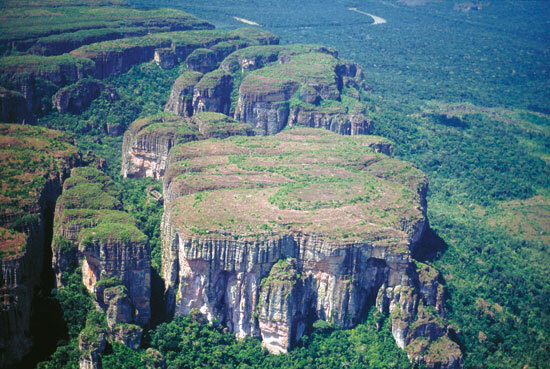
© Carlos Castaño Uribe, CC BY-SA 3.0 Resized from original. (This derivative is under the same CC BY-SA license.)
World Heritage Research
Discover scientific research and academic studies that deepen our understanding of Chiribiquete National Park – “The Maloca of the Jaguar” from its history and significance to its conservation, management, and contemporary challenges.
-
A multi-species corridor between the Andean Amazonian and Amazon floodplain landscapes: prioritizing ecological connectivity areas for jaguar and threatened ungulates in the north-eastern of South America
Researchers have identified a critical multi-species corridor spanning the Andean Amazonian and Amazon floodplain landscapes, essential for maintaining ecological connectivity for jaguars and threatened ungulates like the lowland tapir and collared peccary. This corridor, primarily associated with the hydric network of the upper and middle Caquetá River basin, connects key protected areas such as Alto Fragua Indi Wasi, La Paya, and Serranía del Chiribiquete National Natural Parks, as well as several regional parks. The study utilized potential distribution models, spatial morphological analysis, and resistance matrix modeling to pinpoint low-cost dispersal routes and prioritize connectivity nodes using the randomized shortest path algorithm. These findings highlight the importance of preserving these corridors to safeguard biodiversity in the face of accelerating habitat degradation due to deforestation, cattle ranching, and infrastructure development.
Mosquera-Guerra, F., Barreto, S., Palencia-Rivera, J. D., Velásquez-Valencia, A., Mantilla-Meluk, H., Bruges-Morales, G. A., Jiménez-Ortega, A. M., Trujillo, F., & Armenteras-Pascual, D. (2025). A multi-species corridor between the Andean Amazonian and Amazon floodplain landscapes: prioritizing ecological connectivity areas for jaguar and threatened ungulates in the north-eastern of South America. Discover Conservation, 2(1). https://doi.org/10.1007/s44353-025-00032-4
View Publication Record | Read Publication -
A multi-species corridor between the Andean Amazonian and Amazon floodplain landscapes: prioritizing ecological connectivity areas for jaguar and threatened ungulates in the north-eastern of South America
Research identifies a critical multi-species corridor spanning the Andean Amazonian and Amazon floodplain landscapes, facilitating dispersal for jaguars and threatened ungulates like tapirs and peccaries. This corridor, primarily linked to the hydric network of the Caquetá River basin, connects key protected areas such as Serranía del Chiribiquete National Natural Park and others, ensuring ecological connectivity amid habitat degradation from deforestation and infrastructure development. The study employed potential distribution models, spatial morphological analysis, and resistance matrices to model dispersal routes and quantify global connectivity metrics using a multi-species approach that considers predator-prey relationships.
Mosquera-Guerra, F., Barreto, S., Palencia-Rivera, J. D., Velásquez-Valencia, A., Mantilla-Meluk, H., Bruges-Morales, G. A., Jiménez-Ortega, A. M., Trujillo, F., & Armenteras-Pascual, D. (2024). A multi-species corridor between the Andean Amazonian and Amazon floodplain landscapes: prioritizing ecological connectivity areas for jaguar and threatened ungulates in the north-eastern of South America . https://doi.org/10.21203/rs.3.rs-4838053/v1
View Publication Record | Read Publication -
Landscape connectivity loss after the de-escalation of armed conflict in the Colombian Amazon (2011–2021)
A significant increase in deforestation and landscape connectivity loss has been observed in the Colombian Amazon following the 2016 peace agreement with FARC, particularly around the Serranía de Chiribiquete National Park. Annual deforested area surged from an average of 27.93 km² before 2016 to 73.36 km² afterward, driven by pasture expansion along rivers and roads used for cattle transport. The study employed Landsat archive data, the Continuous Change Detection and Classification algorithm (CCDC), and Morphological Spatial Pattern Analysis (MSPA) to quantify these changes, revealing a shrinking core forest area and expanding edge and background areas dominated by pastures. These findings underscore the need for targeted policy interventions to preserve ecological connectivity and mitigate further environmental degradation in this critical region.
López, J., Qian, Y., Murillo-Sandoval, P. J., Clerici, N., & Eklundh, L. (2024). Landscape connectivity loss after the de-escalation of armed conflict in the Colombian Amazon (2011–2021). Global Ecology and Conservation, 54, e03094. https://doi.org/10.1016/j.gecco.2024.e03094
View Publication Record | Read Publication -
Digitizing and Documenting Heritage for Conservation, A Case Study: Chiribiquete National Park Archaeological Site
High-resolution 3D digitization emerges as a transformative tool for the conservation and remote study of UNESCO World Heritage Sites, demonstrated by its application at Chiribiquete National Park. This method captures the intricate details, scale, and color of Paleoindian pictographs inscribed on Tepui mountain formations with minimal environmental impact or disruption to uncontacted Indigenous communities. The non-invasive approach not only preserves the archaeological heritage but also enables remote analysis and mitigates tourism-related risks, offering a sustainable model for site management.
Cabarcas Granados, M. M., Hamp, E., Santana Quintero, M., Reina Ortiz, M., Montejo Gaitán, F., & Leguizamón, L. P. (2023). DIGITIZING AND DOCUMENTING HERITAGE FOR CONSERVATION, A CASE STUDY: CHIRIBIQUETE NATIONAL PARK ARCHAEOLOGICAL SITE. The International Archives of the Photogrammetry, Remote Sensing and Spatial Information Sciences, XLVIII-M-2-2023, 341–347. https://doi.org/10.5194/isprs-archives-xlviii-m-2-2023-341-2023
View Publication Record | Read Publication -
Sixteen new records of Odonata for Colombia from the Araracuara Region (Perilestidae, Calopterygidae, Heteragrionidae, Megapodagrionidae, Polythoridae, Coenagrionidae, Aeshnidae, Gomphidae, Libellulidae)
A recent field survey in the Araracuara Region of Chiribiquete National Park, Colombia, uncovered 16 new records of Odonata species for the country, including notable additions like Hetaerina charca and Ypirangathemis calverti. The study also documented two genera—Schistolobos and Ypirangathemis—as new to Colombia's biodiversity. Researchers collected a total of 40 species across eight families, contributing critical data to the understanding of dragonfly and damselfly diversity in this UNESCO-listed site. The findings highlight Chiribiquete's ecological significance while emphasizing the need for conservation efforts to protect these unique aquatic insects.
Stand-Pérez, M. Á., Montes-Fontalvo, J., & Pérez-Gutiérrez, L. A. (2021). Sixteen new records of Odonata for Colombia from the Araracuara Region (Perilestidae, Calopterygidae, Heteragrionidae, Megapodagrionidae, Polythoridae, Coenagrionidae, Aeshnidae, Gomphidae, Libellulidae). Notulae Odonatologicae, 9(8). https://doi.org/10.60024/zenodo.5702965
View Publication Record | Read Publication -
Conclusion
Protected areas are pivotal to the conservation of Amazonia, with colossal national parks such as Chiribiquete in Colombia and Tumucumaque in Brazil playing a crucial role. These parks, which dwarf countries like Belgium, serve as strongholds for biodiversity preservation. The study emphasizes the significance of these protected zones in safeguarding the Amazon's ecological integrity amid growing threats. By analyzing the effectiveness and scale of these conservation efforts, the research underscores their vital contribution to global biodiversity strategies.
Plotkin, M. J. (2020). Conclusion. The Amazon. https://doi.org/10.1093/wentk/9780190668297.003.0008
View Publication Record | Read Publication -
Nueva especie de Lonchorhina (Chiroptera: Phyllostomidae) de Chiribiquete, Guayana colombiana
Researchers have identified a new species of sword-nose bat (Lonchorhina) within the Chiribiquete National Park, Colombia, distinguished by its exceptionally large noseleaf (>41.5 mm) and tragus (>22.3 mm), surpassing all known phyllostomid bats. This discovery, based on phenetic analysis of 105 specimens representing five recognized species, highlights the genus's underappreciated diversity. The new taxon, closely related to L. mairkellei and L. inusitata, exhibits a larger skull (GSL mean = 27.31 mm) and more robust dentition. Collected from an inselberg near Rio Mesay, the species honors the Karijona people of Chiribiquete, where ancient Amazon pictograms depict bats, underscoring its cultural significance in this biodiverse yet unexplored region.
mantilla-meluk, h., & Montenegro, O. (2016). Nueva especie de Lonchorhina (Chiroptera: Phyllostomidae) de Chiribiquete, Guayana colombiana. Revista Biodiversidad Neotropical, 6(2 Jul-Dic), 171. https://doi.org/10.18636/bioneotropical.v6i2.576
View Publication Record | Read Publication