World Heritage Identification Number: 1431
World Heritage since: 2025
Category: Natural Heritage
WHE Type: Natural Landscapes & Geographic Features
Transboundary Heritage: No
Endangered Heritage: No
Country: 🇬🇼 Guinea-Bissau
Continent: Africa
UNESCO World Region: Africa
Map
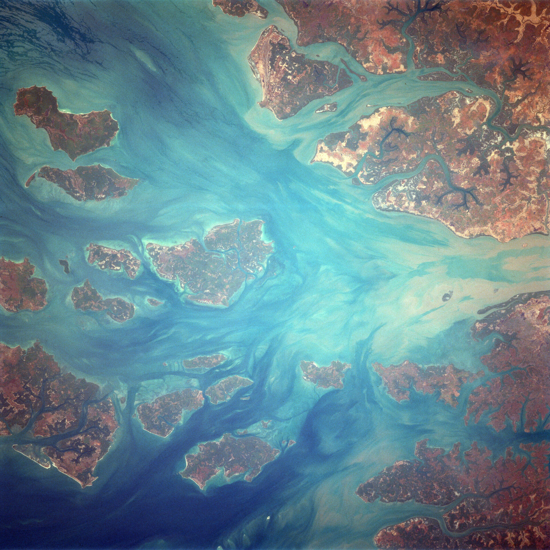
Coastal and Marine Ecosystems of the Bijagós Archipelago - Omatí Minhô: A Unique Biodiversity Haven
The Coastal and Marine Ecosystems of the Bijagós Archipelago - Omatí Minhô, inscribed as a UNESCO World Heritage Site in 2025, represents a remarkable conservation success story in Guinea-Bissau. This extensive network of coastal and marine ecosystems encompasses the marine and intertidal environments of the best-preserved regions within the Bijagós Archipelago.
More to come…UNESCO Description of the World Heritage Site
The property includes a continuous series of coastal and marine ecosystems, corresponding to the marine and intertidal environments of the best-preserved areas of the Bijagós Archipelago in Guinea-Bissau. The Archipelago is the only active deltaic archipelago on the African Atlantic coast and one of the few in the world. The site is home to a rich biodiversity, including endangered Green and Leatherback turtles, manatees, dolphins, and over 870,000 migratory shorebirds. It features mangroves, mudflats, and intertidal zones vital for marine life, and supports rare plant species, diverse fish populations, and bird colonies. Poilão Island is a globally important nesting site for turtles.
UNESCO Justification of the World Heritage Site
Criterion (ix): The Bijagós Archipelago is the only active deltaic archipelago on the Atlantic coast of Africa. The archipelago is particularly important, on the African continent as well as in the Atlantic Ocean and throughout the world, due in particular to the rugged coastline, the width of the continental shelf, the geological and ecological marine processes and land-sea interactions, and the presence of mangroves, estuaries and foreshore shoals. Its origin can be found in the characteristic layout of the islands and delta-shaped channels. The existence of the delta is determined by a series of processes such as the tide, the sedimentary input from the Geba and Corubal rivers, the production and exchange of nutrients in the estuaries and mangroves of the Costa das Rias, upwelling and the convergence of the north and south littoral drifts, which favour the trapping of sediments. These dynamic processes, coupled with shallow areas and reefs, create conditions for high ecological productivity and an important food chain for the maintenance and conservation of life in the marine and intertidal environments where the availability of crustaceans, molluscs and other food sources favours large gatherings of water birds, sharks and rays, manatees, dolphins, sea turtles, among others, some of which are essential for the major migration routes. The deltaic origin of the archipelago also explains the presence of freshwater species that have had to adapt to the progression of marine influences over the millennia. The most representative example is that of the Hippopotamus, the archipelago being the only place on the continent, and thus in the world, where the species lives in seawater on an almost permanent basis.
Criterion (x): The vast sand and mud banks and other foreshore habitats of the property constitute key environments for migratory and/or resident species, in particular wading birds, coastal and marine birds, and sea turtles, among other globally important and threatened species. In these conditions, it constitutes the second most important feeding area in West Africa for the East Atlantic Flyway beyond the resident bird colonies. Total estimates range from around 200,000 to 850,000 birds. This includes nearly 105 species of waterbirds, including 53 resident Afrotropical species (from 18 families) and 50 Palaearctic and intra-African migratory species (from 19 families), out of a total of more than 283 species of birds throughout the archipelago. Furthermore, it is probably the most important site in Africa and one of the most important in the world for nesting sea turtles. Five of the seven existing species of sea turtle frequent the Bijagós Archipelago: the Green Turtle, the Olive Ridley Turtle, the Hawksbill Turtle, the Leatherback Turtle and the Loggerhead Turtle. The nesting of Green Turtles is nevertheless the most remarkable, making the property the third most important area in the world, the second most important in the South Atlantic and the most important in the whole of Africa, in terms of the number of nests. Starting from an annual average of 27,251 Green Turtle nests between 2013 and 2017, the records have repeatedly reached almost 40,000 nests, and up to more than 62,000 in 2020, for the beaches of the islet of Poilão alone. Regional and transatlantic migrations of sea turtles have been recorded in association with the property. The property is also a sanctuary for the diversity of sharks and rays, being probably the area with the greatest hopes among the three most important areas in the world for coastal elasmobranchs, and is renowned for the diversity of its fish populations, particularly cartilaginous fish, including the probable last specimens of sawfish on the West African coast. Further threatened species found in the property include African Manatee, dolphins – in particular the Atlantic Humpback Dolphin – and hippopotamuses living in marine habitats.
Encyclopedia Record: Bijagós Islands
The Bijagós Islands, also spelled Bijagos and formerly known as Bissagos, are a group of about 88 islands and islets located in the Atlantic Ocean off the coast of Guinea-Bissau.Additional Site Details
Area: 394,067.3 hectares
Number of Components: 1
(x) — Contains most important habitats for biodiversity
Coordinates: 11.12 , -15.9488888889
Image
NASA / Crew of STS-37, Public domain
