World Heritage Identification Number: 186
World Heritage since: 1982
Category: Natural Heritage
WHE Type: Natural Landscapes & Geographic Features
Transboundary Heritage: No
Endangered Heritage: No
Country: 🇦🇺 Australia
Continent: Oceania
UNESCO World Region: Asia and the Pacific
Map
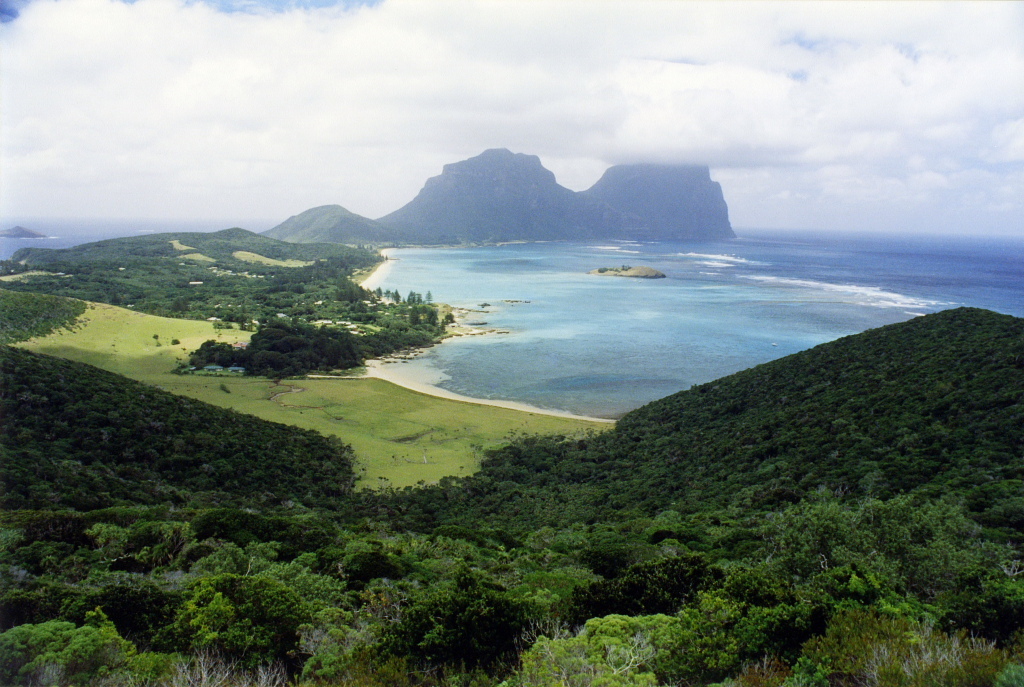
Lord Howe Island Group: An Unspoiled Volcanic Paradise
The Lord Howe Island Group, inscribed as a UNESCO World Heritage Site in 1982, presents a unique and captivating landscape that showcases the wonders of isolated oceanic islands. Situated approximately 600 kilometers east of mainland Port Macquarie, New South Wales, Australia, this volcanic archipelago offers a breathtaking spectacle of geological diversity and ecological richness.
More to come…UNESCO Description of the World Heritage Site
A remarkable example of isolated oceanic islands, born of volcanic activity more than 2,000 m under the sea, these islands boast a spectacular topography and are home to numerous endemic species, especially birds.
UNESCO Justification of the World Heritage Site
Criterion (vii): The Lord Howe Island Group is grandiose in its topographic relief and has an exceptional diversity of spectacular and scenic landscapes within a small area, including sheer mountain slopes, a broad arc of hills enclosing the lagoon and Balls Pyramid rising abruptly from the ocean. It is considered to be an outstanding example of an island system developed from submarine volcanic activity and demonstrates the nearly complete stage in the destruction of a large shield volcano. Having the most southerly coral reef in the world, it demonstrates a rare example of a zone of transition between algal and coral reefs. Many species are at their ecological limits, endemism is high, and unique assemblages of temperate and tropical forms cohabit. The islands support extensive colonies of nesting seabirds, making them significant over a wide oceanic region. They are the only major breeding locality for the Providence Petrel (Pterodroma solandri), and contain one of the world’s largest breeding concentrations of Red-tailed Tropicbird (Phaethon rubricauda).
Criterion (x): The Lord Howe Island Group is an outstanding example of the development of a characteristic insular biota that has adapted to the island environment through speciation. A significant number of endemic species or subspecies of plants and animals have evolved in a very limited area. The diversity of landscapes and biota and the high number of threatened and endemic species make these islands an outstanding example of independent evolutionary processes. Lord Howe Island supports a number of endangered endemic species or subspecies of plants and animals, for example the Lord Howe Woodhen, which at time of inscription was considered one of the world’s rarest birds. While sadly a number of endemic species disappeared with the arrival of people and their accompanying species, the Lord Howe Island Phasmid, the largest stick insect in the world, still exists on Balls Pyramid. The islands are an outstanding example of an oceanic island group with a diverse range of ecosystems and species that have been subject to human influences for a relatively limited period.
Encyclopedia Record: Lord Howe Island
Lord Howe Island is an irregularly crescent-shaped volcanic remnant in the Tasman Sea between Australia and New Zealand, part of the Australian state of New South Wales. It lies 600 km directly east of mainland Port Macquarie, 780 km northeast of Sydney, and about 900 km southwest of Norfolk Island. It is about 10 km (6.2 mi) long and between 0.3 and 2.0 km wide with an area of 14.55 km2, though just 3.98 km2 of that comprise the low-lying developed part of the island. The island is named after Richard Howe, 1st Earl Howe. Along the west coast is a sandy semi-enclosed sheltered coral reef lagoon. Most of the population lives in the north, while the south is dominated by forested hills rising to the highest point on the island, Mount Gower. The Lord Howe Island Group comprises 28 islands, islets, and rocks. Apart from Lord Howe Island itself, the most notable of these is the volcanic and uninhabited Ball's Pyramid about 23 km to the southeast of Howe. To the north lies the Admiralty Group, a cluster of seven uninhabited islets.Additional Site Details
Area: 146,300 hectares
Number of Components: 1
(x) — Contains most important habitats for biodiversity
Coordinates: -31.56555556 , 159.0883333
IUCN World Heritage Outlook
The 2025 Conservation Outlook on Lord Howe Island Group reports the following assessment:
Source: International Union for Conservation of Nature (IUCN) · View assessment