World Heritage Identification Number: 1492
World Heritage since: 2014
Category: Cultural Heritage
WHE Type: Cultural Landscapes
Transboundary Heritage: No
Endangered Heritage: Yes
Country: 🇵🇸 State of Palestine
Continent: Asia
UNESCO World Region: Arab States
Map
Palestine's Battir: A Terraced Oasis in the West Bank
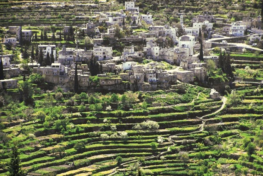
The cultural landscape of southern Jerusalem, Battir, is a unique agricultural area located in the Central Highlands between Nablus and Hebron, approximately 6.4 kilometers west of Bethlehem. This site, inscribed as a UNESCO World Heritage Site in 2014, offers a fascinating glimpse into the rich history and traditional farming practices of Palestine.
More to come…UNESCO Description of the World Heritage Site
This site is located a few kilometres south-west of Jerusalem, in the Central Highlands between Nablus and Hebron. The Battir hill landscape comprises a series of farmed valleys, known as widian, with characteristic stone terraces, some of which are irrigated for market garden production, while others are dry and planted with grapevines and olive trees. The development of terrace farming in such a mountainous region is supported by a network of irrigation channels fed by underground sources. A traditional system of distribution is then used to share the water collected through this network between families from the nearby village of Battir.
UNESCO Justification of the World Heritage Site
Criterion (iv): The dry-stone architecture represents outstanding example of a landscape that illustrates the development of human settlements near water sources and the adaptation of the land for agriculture. The village of Battir, which developed on the outskirts of this cultural landscape, and was inhabited by farmers who worked and still work the land, attests to the sustainability of this system and to its continuation over at least a millennia. The traditional system of irrigated terraces is an outstanding example of technological expertise, which constitutes an integral part of the cultural landscape.
Criterion (v): The strategic location of Battir and the availability of springs were two major factors that attracted people to settle in the area and adapt its steep landscape into arable land. The property is an outstanding example of traditional land-use, which is representative of many centuries of culture and human interaction with the environment. The agricultural practices that were used to create this living landscape reflect one of the oldest farming methods known to humankind and are an important source of livelihood for local communities.
Encyclopedia Record: Battir
Battir is a Palestinian village in the Bethlehem Governorate of the State of Palestine, in the West Bank, 6.4 km west of Bethlehem, and southwest of Jerusalem. In 2017, the village had a population of 4,696.Additional Site Details
Area: 348.83 hectares
Number of Components: 2
(v) — Outstanding example of traditional human settlement
Coordinates: 31.7163888889 , 35.1588888889
Image
© Ali.batha, CC BY-SA 4.0 Resized from original. (This derivative is under the same CC BY-SA license.)
