World Heritage Identification Number: 113
World Heritage since: 1979
Category: Cultural Heritage
WHE Type: Archaeological Sites
Transboundary Heritage: No
Endangered Heritage: No
Country: 🇮🇷 Iran (Islamic Republic of)
Continent: Asia
UNESCO World Region: Asia and the Pacific
Map
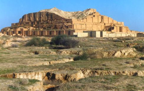
Chogha Zanbil: An Unfinished Ziggurat in Ancient Elam
Chogha Zanbil, also known as Al Untas Napirisa or Dur Untash, is an exceptional archaeological site located in the Khuzestan province of Iran. This ancient Elamite complex, dating back to the 14th or 13th century BC, is one of the few existing ziggurats outside Mesopotamia and is recognized as a UNESCO World Heritage Site since 1979.
More to come…UNESCO Description of the World Heritage Site
The ruins of the holy city of the Kingdom of Elam, surrounded by three huge concentric walls, are found at Tchogha Zanbil. Founded c. 1250 B.C., the city remained unfinished after it was invaded by Ashurbanipal, as shown by the thousands of unused bricks left at the site.
UNESCO Justification of the World Heritage Site
Criterion (iii): The ruins of Susa and of Tchogha Zanbil are the sole testimonies to the architectural development of the middle Elamite period (1400-1100 BCE).
Criterion (iv): The ziggurat at Tchogha Zanbil remains to this day the best preserved monument of this type and the largest outside of Mesopotamia.
Encyclopedia Record: Chogha Zanbil
Chogha Zanbil, Elamite: Al Untas Napirisa, later Dur Untash, is an ancient Elamite complex in the Khuzestan province of Iran. It is one of the few existing ziggurats outside Mesopotamia. It lies approximately 30 km (19 mi) southeast of Susa and 80 km (50 mi) north of Ahvaz. The construction date of the city is unclear due to uncertainty in the chronology of the reign of Untash-Napirisha, but is clearly sometime in the 14th or 13th century BC. The conventionally assumed date is 1250 BC. The city is currently believed to have been destroyed by the Neo-Assyrian ruler Assurbanipal in about 645 BC, along with the Elamite capital of Susa, though some researchers place the end of occupation in the late 12th century BC. The ziggurat is considered to be the best preserved example of the stepped pyramidal monument by UNESCO. In 1979, Chogha Zanbil became the first Iranian site to be inscribed on the UNESCO World Heritage List.Additional Site Details
Area: Not available
Number of Components: 1
(iv) — Outstanding example of a type of building or landscape
Coordinates: 32.00857 , 48.522118
Image
© Unknown, CC BY-SA 3.0 Resized from original. (This derivative is under the same CC BY-SA license.)
