World Heritage Identification Number: 194
World Heritage since: 1982
Category: Cultural Heritage
WHE Type: Archaeological Sites
Transboundary Heritage: No
Endangered Heritage: No
Country: 🇩🇿 Algeria
Continent: Africa
UNESCO World Region: Arab States
Map
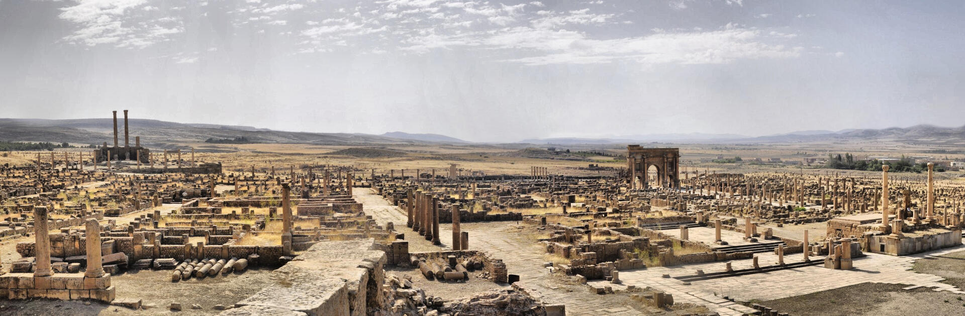
Timgad: A Well-Preserved Example of Roman Urban Planning
Timgad, officially known as Colonia Marciana Ulpia Traiana Thamugadi, is a remarkable testament to the architectural prowess of the ancient Romans. Located in the Aurès Mountains of modern-day Algeria, this UNESCO World Heritage Site was established in AD 100 by Emperor Trajan as a military colony. Its exceptional preservation offers a unique insight into Roman urban planning and daily life during the Roman Empire.
More to come…UNESCO Description of the World Heritage Site
Timgad lies on the northern slopes of the Aurès mountains and was created ex nihilo as a military colony by the Emperor Trajan in AD 100. With its square enclosure and orthogonal design based on the cardo and decumanus, the two perpendicular routes running through the city, it is an excellent example of Roman town planning.
UNESCO Justification of the World Heritage Site
Criterion (ii): The site of Timgad, with its Roman military camp, its model town-planning and its particular type of civil and military architecture reflects an important interchange of ideas, technologies and traditions exercised by the central power of Rome on the colonisation of the high plains of Antique Algeria.
Criterion (iii): Timgad adopts the guidelines of Roman town-planning governed by a remarkable grid system. Timgad thus constitutes a typical example of an urban model, the permanence of the original plan of the military encampment having governed the development of the site throughout all the ulterior periods and still continues to bear witness to the building inventiveness of the military engineers of the Roman civilization, today disappeared.
Criterion (iv): Timgad possesses a rich architectural inventory comprising numerous and diversified typologies, relating to the different historical stages of its construction: the defensive system, buildings for the public conveniences and spectacles, and a religious complex. Timgad illustrates a living image of Roman colonisation in North Africa over three centuries.
Encyclopedia Record: Timgad
Timgad was a Roman city in the Aurès Mountains of Algeria. It was founded by the Roman Emperor Trajan around 100 AD. The full name of the city was Colonia Marciana Ulpia Traiana Thamugadi. Emperor Trajan named the city in commemoration of his mother Marcia, eldest sister Ulpia Marciana, and father Marcus Ulpius Traianus.Additional Site Details
Area: 90.54 hectares
Number of Components: 1
(iii) — Unique or exceptional testimony to a cultural tradition
(iv) — Outstanding example of a type of building or landscape
Coordinates: 35.4841666667 , 6.4688611111
Image
© Hamza-sia, CC BY-SA 3.0 Resized from original. (This derivative is under the same CC BY-SA license.)
