World Heritage Identification Number: 653
World Heritage since: 1993
Category: Natural Heritage
WHE Type: Natural Landscapes & Geographic Features
Transboundary Heritage: No
Endangered Heritage: No
Country: 🇵🇭 Philippines
Continent: Asia
UNESCO World Region: Asia and the Pacific
Map
Tubbataha Reefs Natural Park: A Biodiversity Haven in the Sulu Sea
The Tubbataha Reefs Natural Park, officially recognized by UNESCO as a World Heritage Site since 1993, is a remarkable testament to the rich biodiversity found in the heart of the Sulu Sea. Located approximately 150 kilometers southeast of Puerto Princesa, the capital of Palawan, this marine and bird sanctuary spans over 97,030 hectares, encompassing two substantial atolls – North and South Atolls – and the smaller Jessie Beazley Reef.
More to come…UNESCO Description of the World Heritage Site
The Tubbataha Reef Marine Park covers 96,828 ha, including the North and South Atolls and the Jessie Beazley Reef. It is a unique example of an atoll reef with a very high density of marine species; the North Islet serving as a nesting site for birds and marine turtles. The site is an excellent example of a pristine coral reef with a spectacular 100-m perpendicular wall, extensive lagoons and two coral islands.
UNESCO Justification of the World Heritage Site
Criterion (vii): Tubbataha Reefs Natural Park contains excellent examples of pristine reefs with a high diversity of marine life. The property includes extensive reef flats and perpendicular walls reaching over 100m depth, as well as large areas of deep sea. The remote and undisturbed character of the property and the continued presence of large marine fauna such as tiger sharks, cetaceans and turtles, and big schools of pelagic fishes such as barracuda and trevallies add to the aesthetic qualities of the property.
Criterion (ix): Tubbataha Reefs Natural Park lies in a unique position in the middle of the Sulu Sea and is one of the Philippines’ oldest ecosystems. It plays a key role in the process of reproduction, dispersal and colonization by marine organisms in the whole Sulu Sea system, and helps support fisheries outside its boundaries. The property is a natural laboratory for the study of ecological and biological processes, displaying the ongoing process of coral reef formation, and supporting a large number of marine species dependant on reef ecosystems. The presence of top predator species, such as tiger and hammerhead sharks, are indicators of the ecological balance of the property. The property also offers a demonstration site to study the responses of a natural reef system in relation to the impacts of climate change.
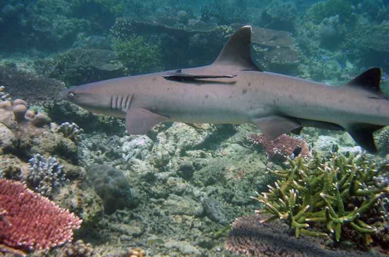
Criterion (x): Tubbataha Reefs Natural Park provides an important habitat for internationally threatened and endangered marine species. The property is located within the Coral Triangle, a global focus for coral biological diversity. The reefs of the property support 360 species of corals, almost 90% of all coral species in the Philippines. The reefs and seas of the property also support eleven species of cetaceans, eleven species of sharks, and an estimated 700 species of fishes, including the iconic and threatened Napoleon wrasse. The property supports the highest population densities known in the world for white tip reef sharks. Pelagic species such as jacks, tuna, barracuda, manta rays, whale sharks and different species of sharks also are common here and the property is a very important nesting, resting and juvenile development area for two species of endangered marine turtles: green turtles and hawksbill turtles. There are seven breeding species of seabirds and Bird Islet and South Islet are breeding grounds to seven resident and endangered breeding species of seabirds. The critically endangered Christmas Island Frigatebird is a regular visitor to the property.
Encyclopedia Record: Tubbataha Reef
The Tubbataha Natural Park, also known as the Tubbataha Reefs Natural Park, is a protected area of the Philippines located in the middle of the Sulu Sea. The marine and bird sanctuary consists of two huge atolls and the smaller Jessie Beazley Reef covering a total area of 97,030 hectares. It is located 150 kilometres (93 mi) southeast of Puerto Princesa, the capital of Palawan. The uninhabited islands and reefs are part of the island municipality of Cagayancillo, located roughly 130 kilometers (81 mi) to the northeast of the reef.Additional Site Details
Area: 96,828 hectares
Number of Components: 1
(ix) — Outstanding example representing ecological and biological processes
(x) — Contains most important habitats for biodiversity
Coordinates: 8.9533333333 , 119.8675
IUCN World Heritage Outlook
The 2025 Conservation Outlook on Tubbataha Reefs Natural Park reports the following assessment:
Source: International Union for Conservation of Nature (IUCN) · View assessment
Image
© Simon Hefti, Schweiz (de:User:Nikswieweg), CC BY-SA 3.0 Resized from original. (This derivative is under the same CC BY-SA license.)
