World Heritage Identification Number: 63
World Heritage since: 1979
Category: Natural Heritage
WHE Type: Protected Areas & National Parks
Transboundary Heritage: No
Endangered Heritage: Yes
Country: 🇨🇩 Democratic Republic of the Congo
Continent: Africa
UNESCO World Region: Africa
Map
Virunga National Park: A Biodiversity Haven in the Heart of Africa
Virunga National Park, located in the Democratic Republic of the Congo (DRC), is a testament to the rich biodiversity and geographical diversity that characterizes the African continent. Established in 1925, this expansive protected area spans an area of approximately 8,090 square kilometers, making it one of the largest national parks in Africa. The park's location within the Albertine Rift Valley, a region known for its unique species of flora and fauna, further enhances its significance.
More to come…UNESCO Description of the World Heritage Site
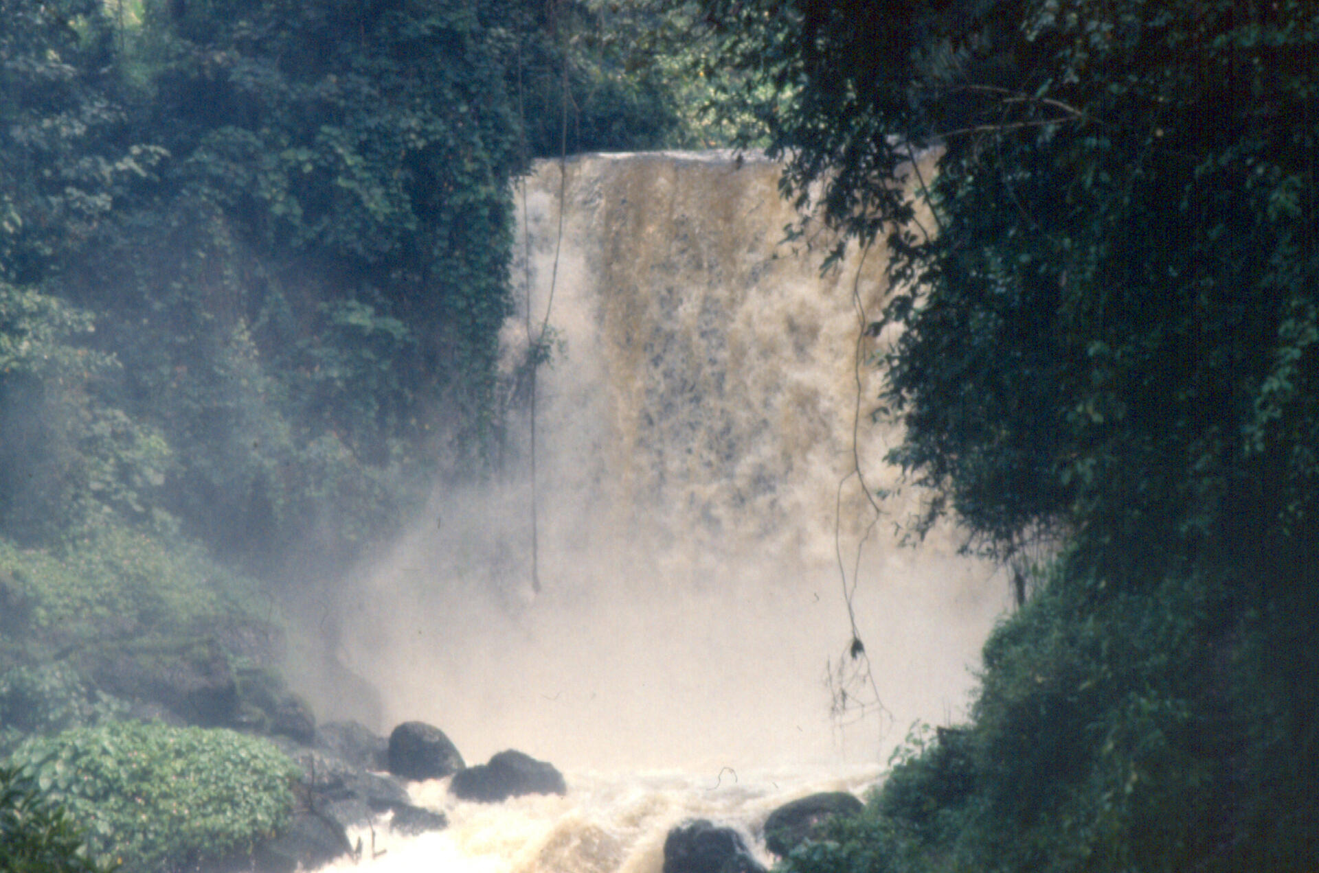
Virunga National Park (covering an area of 790,000 ha) comprises an outstanding diversity of habitats, ranging from swamps and steppes to the snowfields of Rwenzori at an altitude of over 5,000 m, and from lava plains to the savannahs on the slopes of volcanoes. Mountain gorillas are found in the park, some 20,000 hippopotamuses live in the rivers and birds from Siberia spend the winter there.
UNESCO Justification of the World Heritage Site
Criterion (vii): Virunga National Park offers the most spectacular montane landscapes in Africa. Mt Rwenzori with its jagged reliefs and snowy summits, their cliffs and steep valleys, and the volcanoes of the Virunga massif covered with an afro-alpine vegetation of tree ferns and Lobelia and their slopes covered by dense forests, are the places of exceptional natural beauty. The volcanoes, which erupt at regular intervals every few years, constitute the dominant land features of the outstanding landscape. The Park presents several other spectacular panoramas like the eroded valleys in the Sinda and Ishango regions. The Park also contains important concentrations of wildlife, notably elephants, buffalo and Thomas cobs, and the largest concentration of hippopotamuses in Africa, with 20,000 individuals living on the banks of Lake Edward and along the Rwindi, Rutshuru and Semliki Rivers.
Criterion (viii): Virunga National Park is located in the centre of the Albertine Rift, of the Great Rift Valley. In the southern part of the Park, tectonic activity due to the extension of the earth’s crust in this region has caused the emergence of the Virunga massif, comprising eight volcanoes, seven of which are located, totally or partially, in the Park. Among them, are the two most active volcanoes of Africa – Nyamuragira and nearby Nyiragongo - which between them are responsible for two-fifths of the historic volcanic eruptions on the African continent and which are characterized by the extreme fluidity of the alkaline lava. The activity of Nyiragongo is of world importance as a witness to volcanism of a lava lake: the bottom of its crater is in fact filled by a lake of quasi permanent lava that empties periodically with catastrophic consequences for the local communities. The northern sector of the Park includes about 20% of the massif of Monts Rwenzori – the largest glacial region of Africa and the only true alpine mountain chain of the continent. It borders the Rwenzori Mountains National Park of Uganda, inscribed as World Heritage, with which it shares the ‘Pic Marguerite’, third highest summit of Africa (5,109 m).
Criterion (x): Due to its variations in altitude (from 680 m to 5,109 m), rainfall and nature of the ground, Virunga National Park possesses a very wide diversity of plants and habitats, making it the top African National Park for biological diversity. More than 2,000 premier plant species have been identified, of which 10% are endemic to the Albertine Rift. The afro-montane forests represent about 15% of the vegetation. The Rift Albertine also contains more endemic vertebrate species than any other region of the African continent and the Park possesses numerous examples of them. The Park contains 218 mammal species, 706 bird species, 109 reptile species and 78 amphibian species. It also serves as refuge to 22 primate species of which three are the great ape – mountain gorilla (Gorilla beringei beringei), the eastern plain gorilla (Gorilla beringei graueri) and the eastern chimpanzee (Pan troglodytes schweinfurthi), with a third of the world population of mountain gorillas. The savannah zones of the Park contain a diverse population of ungulates and the density of biomass of wildlife is one of the highest on the earth Planet (27.6 ton/km2). Among the ungulates, there are certain rare animals such as the okapi (Okapi johnstoni), endemic to the Democratic Republic of the Congo, and the red forest duiker (Cephalophus rubidus), endemic to Monts Rwenzori. The Park also comprises important tropical zones essential for the wintering of Palearctic avifauna.
Encyclopedia Record: Virunga National Park
Virunga National Park is a national park in the Albertine Rift Valley in the eastern part of the Democratic Republic of the Congo. It was created in 1925. In elevation, it ranges from 680 m (2,230 ft) in the Semliki River valley to 5,109 m (16,762 ft) in the Rwenzori Mountains. From north to south it extends approximately 300 km (190 mi), largely along the international borders with Uganda and Rwanda in the east. It covers an area of 8,090 km2 (3,120 sq mi).Additional Site Details
Area: 8e+05 hectares
Number of Components: 1
(viii) — Outstanding example representing major earth stages
(x) — Contains most important habitats for biodiversity
Coordinates: 0.916666667 , 29.16666667
IUCN World Heritage Outlook
The 2025 Conservation Outlook on Virunga National Park reports the following assessment:
Source: International Union for Conservation of Nature (IUCN) · View assessment
Image
© Ad Meskens, CC BY-SA 3.0 Resized from original. (This derivative is under the same CC BY-SA license.)
