World Heritage Identification Number: 1377
World Heritage since: 2011
Category: Mixed Cultural Heritage and Natural Heritage
WHE Type: Protected Areas & National Parks
Transboundary Heritage: No
Endangered Heritage: No
Country: 🇯🇴 Jordan
Continent: Asia
UNESCO World Region: Arab States
Map
Wadi Rum Protected Area: A Journey Through Time and Landscape
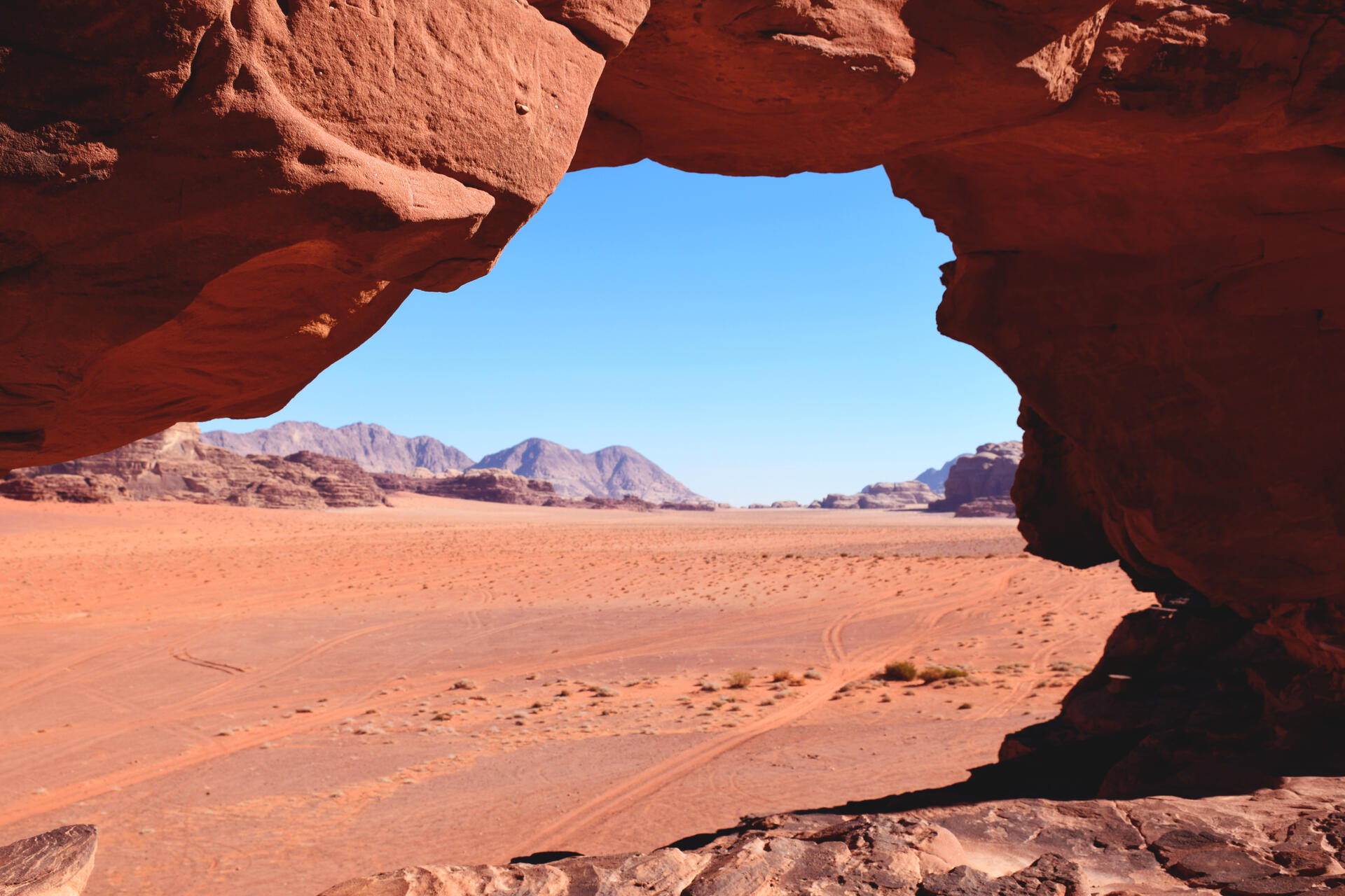
The Wadi Rum Protected Area, often referred to as the Valley of the Moon or Red Mountains, is a geographical marvel located in southern Jordan, bordering Saudi Arabia and approximately 60 kilometers east of the city of Aqaba. Covering an expansive area of 720 square kilometers, it is the largest wadi (valley) in Jordan. This protected area was inscribed as a UNESCO World Heritage Site in 2011, acknowledging its unique blend of natural beauty and rich cultural history.
More to come…UNESCO Description of the World Heritage Site
The 74,000-hectare property, inscribed as a mixed natural and cultural site, is situated in southern Jordan, near the border with Saudi Arabia. It features a varied desert landscape consisting of a range of narrow gorges, natural arches, towering cliffs, ramps, massive landslides and caverns. Petroglyphs, inscriptions and archaeological remains in the site testify to 12,000 years of human occupation and interaction with the natural environment. The combination of 25,000 rock carvings with 20,000 inscriptions trace the evolution of human thought and the early development of the alphabet. The site illustrates the evolution of pastoral, agricultural and urban activity in the region.
UNESCO Justification of the World Heritage Site
Criterion (iii): The rock art, inscriptions and archaeological evidence in WRPA can be considered an exceptional testimony of the cultural traditions of its early inhabitants. The combination of 25,000 petroglyphs, 20,000 inscriptions, and 154 archaeological sites provides evidence to continuity of habitation and land-use over a period of at least 12,000 years. The petroglyphs, representing human and animal figures, are engraved on boulders, stones, and cliff faces. They provide evidence of long-term patterns of pastoral, agricultural and urban human activity in the property. Engravings indicate an elaborate sense of aesthetics in a pictorial culture, and the archaeological findings span all eras from the Neolithic to the Nabataean. Thamudic, Nabataean and numerous Arabic inscriptions in four different scripts testify to the widespread literacy among its pastoral societies.
Criterion (v): The variety of landforms at WRPA has played an essential role in fostering human settlement. The rock art, inscriptions and water catchment systems document the settlements of successive communities, which developed in areas of mobile animal husbandry and agriculture and form part of a wider context of human interaction with the semi-arid eastern desert environment of the Arabian Peninsula. WRPA assists the understanding of the continuum of settled and mobile lifestyles in a desert landscape illustrating the adaptability and ingenuity of human communities who have made the most of scarce resources to sustain continuous presence after the climate became dryer in the Bronze Age (3rd millennium BC).
Criterion (vii): WRPA is recognised globally as an iconic desert landscape, renowned for its spectacular series of sandstone mountains and valleys, natural arches, and the range of narrow gorges, towering cliffs, massive landslides, and dramatic cavernous weathering forms displayed. Key attributes of the aesthetic values of the property include the diversity and sheer size of its landforms, together with the mosaic of colours, vistas into both narrow canyons and very large wadis, and the scale of the cliffs. The property displays, in a protected setting, an exceptional combination of landforms resulting from drainage incision, severe weathering by salt, biological and other processes, and the undermining of steep sandstone cliffs by these weathering processes, together with the world’s most spectacular networks of honeycomb weathering features. Its associations with the writings of T.E. Lawrence, stressed strongly in the nomination, have ensured a high profile for the property and have reinforced its reputation of the area as a classic desert landscape both globally and within the Arab States.
Encyclopedia Record: Wadi Rum
Wadi Rum (Arabic: وادي رم Wādī Ramm, also Wādī al-Ramm, known also as the Valley of the Moon or Red mountains, is a valley cut into the sandstone and granite rock in southern Jordan, near the border with Saudi Arabia and about 60 km to the east of the city of Aqaba. With an area of 720 km2 it is the largest wadi in Jordan.Additional Site Details
Area: 74,179.7 hectares
Number of Components: 1
(v) — Outstanding example of traditional human settlement
(vii) — Contains superlative natural phenomena or beauty
Coordinates: 29.6397222222 , 35.4338888889
IUCN World Heritage Outlook
The 2025 Conservation Outlook on Wadi Rum Protected Area reports the following assessment:
Source: International Union for Conservation of Nature (IUCN) · View assessment