World Heritage Identification Number: 954
World Heritage since: 2002
Category: Cultural Heritage
WHE Type: Religious Sites & Sacred Architecture
Transboundary Heritage: No
Endangered Heritage: No
Country: 🇪🇬 Egypt
Continent: Africa
UNESCO World Region: Arab States
Map
The Sacred Landscape of Saint Catherine Area: A Religious and Cultural Crossroads
The Saint Catherine Area, inscribed as a UNESCO World Heritage Site in 2002, is a unique and significant location that bridges the spiritual realms of three major world religions: Christianity, Islam, and Judaism. Situated at the foot of Mount Horeb, more commonly known as Mount Sinai, this region holds immense historical, cultural, and architectural importance.
More to come…UNESCO Description of the World Heritage Site
The Orthodox Monastery of St Catherine stands at the foot of Mount Horeb where, the Old Testament records, Moses received the Tablets of the Law. The mountain is known and revered by Muslims as Jebel Musa. The entire area is sacred to three world religions: Christianity, Islam, and Judaism. The Monastery, founded in the 6th century, is the oldest Christian monastery still in use for its initial function. Its walls and buildings of great significance to studies of Byzantine architecture and the Monastery houses outstanding collections of early Christian manuscripts and icons. The rugged mountainous landscape, containing numerous archaeological and religious sites and monuments, forms a perfect backdrop to the Monastery.
UNESCO Justification of the World Heritage Site
Criterion (i): The architecture of Saint Catherine's Monastery, the artistic treasures that it houses, and its domestic integration into a rugged landscape, combine to make it an outstanding example of human creative genius.
Criterion (iii): Saint Catherine's Monastery is one of the very early outstanding examples in Eastern tradition of a Christian monastic settlement located in a remote area, demonstrating an intimate relationship between natural grandeur and spiritual commitment. It is the oldest Christian monastery retaining its function without break from its foundation until today.
Criterion (iv): Ascetic monasticism in remote areas prevailed in the early Christian church and resulted in the establishment of monastic communities in remote places. Saint Catherine's Monastery is one of the earliest of these and the oldest to have survived intact, being used for its initial function without interruption since the 6th century.
Criterion (vi): Saint Catherine’s Area, cantered on the holy mountain of Mount Sinaï (Jebel Musa, Mount Horeb), like the Old City of Jerusalem, is sacred to three world religions: Christianity, Islam, and Judaism. It is thought to be the place where Moses received the Tablets of the Law.
Encyclopedia Record: Saint Catherine's Monastery
Saint Catherine's Monastery, officially the Sacred Autonomous Royal Monastery of Saint Catherine of the Holy and God-Trodden Mount Sinai, is a Christian monastery located in the Sinai Peninsula of Egypt. Located at the foot of Mount Sinai, it was built between 548 and 565, and is the world's oldest continuously inhabited Christian monastery.Additional Site Details
Area: 60,100 hectares
Number of Components: 1
(iii) — Unique or exceptional testimony to a cultural tradition
(iv) — Outstanding example of a type of building or landscape
(vi) — Directly associated with events or living traditions
Coordinates: 28.55623 , 33.97543
Image
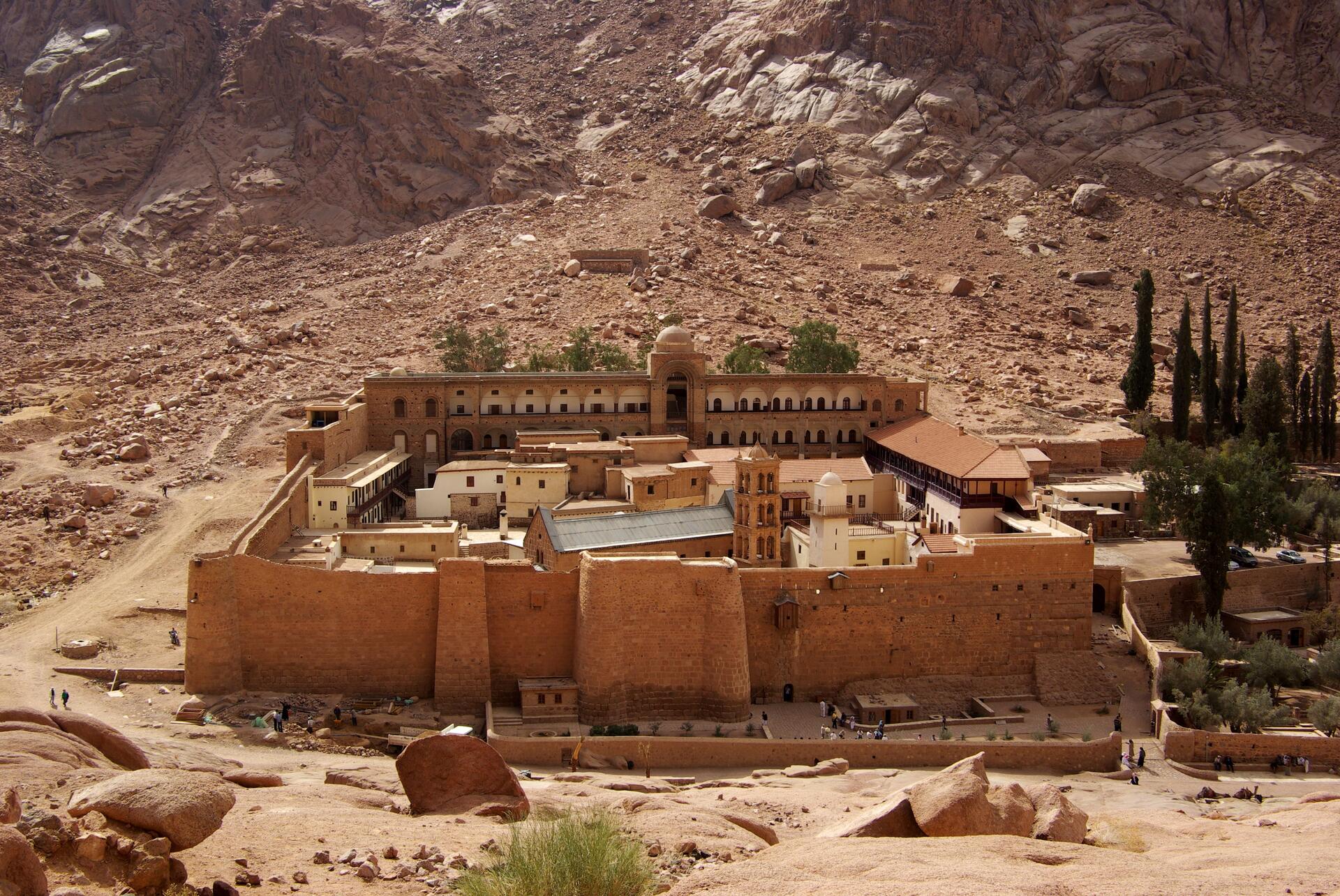
© Berthold Werner, CC BY-SA 3.0 Resized from original. (This derivative is under the same CC BY-SA license.)
World Heritage Research
Discover scientific research and academic studies that deepen our understanding of Saint Catherine Area from its history and significance to its conservation, management, and contemporary challenges.
-
Population status, habitat preferences and predictive current and future distributions of three endangered Silene species under changing climate
Three endangered Silene species in Egypt's Saint Catherine Area face ongoing population decline due to climate change and habitat degradation. Research using field surveys, historical records, Random Forest (RF) analysis, Canonical Correspondence Analysis (CCA), and predictive modeling revealed critical habitat variables—elevation, soil texture, moisture, slope, and precipitation—as key determinants of their distribution. The central northern sector is identified as a hotspot for current suitable habitats, with projected contractions by 2050 and 2070 under climate change scenarios. Urgent conservation measures, including ex-situ preservation and fenced enclosures, are recommended to mitigate threats and ensure survival.
Abdelaal, M., AL-Huqail, A. A., Alghanem, S. M. S., Alhaithloul, H. A. S., Al-Robai, S. A., Abeed, A. H. A., Dakhil, M. A., El-Barougy, R. F., & Yahia, A. A. (2024). Population status, habitat preferences and predictive current and future distributions of three endangered Silene species under changing climate. Frontiers in Plant Science, 15. https://doi.org/10.3389/fpls.2024.1336911
View Publication Record | Read Publication -
Predicting the effect of climate change on the spatiotemporal distribution of two endangered plant species, Silene leucophylla Boiss. and Silene schimperiana Boiss., using machine learning, in Saint Catherine Protected Area, Egypt
Climate change is projected to significantly reduce or eliminate the suitable habitats for two endangered plant species, Silene leucophylla and Silene schimperiana, in Egypt's Saint Catherine Protected Area by 2080. The study used machine learning algorithms to model their current distributions and predict future changes under the worst-case climate scenario (RCP8.5). While S. leucophylla faces rapid range contraction by 2050-2070, S. schimperiana may experience both habitat loss and expansion in some areas before disappearing entirely. Key environmental factors like precipitation, temperature, altitude, and seasonality were critical predictors of their distribution. The findings underscore the urgent need for conservation strategies to protect these vulnerable species from climate-driven threats.
Refaat, A. M., Youssef, A. M., Mosallam, H. A.-A., & Farouk, H. (2024). Predicting the effect of climate change on the spatiotemporal distribution of two endangered plant species, Silene leucophylla Boiss. and Silene schimperiana Boiss., using machine learning, in Saint Catherine Protected Area, Egypt. Beni-Suef University Journal of Basic and Applied Sciences, 13(1). https://doi.org/10.1186/s43088-024-00553-2
View Publication Record | Read Publication -
Geological and Mineralogical Studies of U-Th-Bearing Pegmatites at Gabal Suwair and Gabal Khosh Daba Area, Saint Catherine, South Central Sinai, Egypt
A significant discovery of uranium and thorium mineralization has been identified in the pegmatites of Gabal Suwair and Gabal Khosh Daba, located north of St. Katherine city in South-Central Sinai, Egypt. These pegmatites, among the youngest outcropped rocks in the region, exhibit high levels of equivalent uranium (eU) and thorium (eTh), with maximum values reaching 670 ppm and 180 ppm at Gabal Khosh Daba, respectively, and 520 ppm and 330 ppm at Gabal Suwair. The study reveals distinct mineralogical characteristics: zoned pegmatites contain primary uranium minerals like uraninite, brannerite, and carnotite, suggesting a syngenetic origin during magmatic processes, while unzoned pegmatites host secondary uranium minerals such as samarskite, betafite, and uranothorite, likely formed through hydrothermal activity. This research highlights the potential of the Saint Catherine area for uranium and thorium exploration, contributing valuable insights into the geological and mineralogical diversity of this UNESCO World Heritage Site.
NASR, M. (2021). GEOLOGICAL AND MINERALOGICAL STUDIES OF U-Th-BEARING PEGMATITES AT GABAL SUWAIR AND GABAL KHOSH DABA AREA, SAINT CATHERINE, SOUTH CENTRAL SINAI, EGYPT. Nuclear Sciences Scientific Journal, 10(1), 1–24. https://doi.org/10.21608/nssj.2021.266334
View Publication Record | Read Publication -
Predicting the Potential Current and Future Distribution of the Endangered Endemic Vascular Plant Primula boveana Decne. ex Duby in Egypt
A rare and endangered plant, Primula boveana, survives exclusively in the Saint Catherine Protectorate of Egypt. This study predicts its current and future distribution using environmental data, revealing that only 796 individuals exist across a tiny area (250 m²), with key factors including elevation, precipitation, temperature, and soil pH. Field surveys confirmed five previously recorded localities as extinct while no new populations were found. Under climate change scenarios, P. boveana's range may shift upward, contracting at lower elevations but expanding above 2000 meters in southern parts. Conservation efforts are urgently needed, with recommendations for in situ reinforcement and reintroduction actions to protect this critically endangered species.
Abdelaal, M., Fois, M., Dakhil, M. A., Bacchetta, G., & El-Sherbeny, G. A. (2020). Predicting the Potential Current and Future Distribution of the Endangered Endemic Vascular Plant Primula boveana Decne. ex Duby in Egypt. Plants, 9(8), 957. https://doi.org/10.3390/plants9080957
View Publication Record | Read Publication -
The Environmental Impact Assessment of Harvesting Water from Flash Floods )Case Study on Saint Catherine Area - Southern Sinai(
Constructing mountainous lakes to harvest water from flash floods in the Saint Catherine Area of Southern Sinai yields significant positive impacts on social, economic, and biodiversity aspects. The study demonstrates that redirecting flood runoff using walls and gates not only mitigates flash floods but also provides a sustainable water source for greenhouse cultivation of tomatoes and cucumbers. This approach effectively balances environmental management with agricultural productivity, offering a viable solution for arid regions.
Eman, M. A. k., Ezzat, M. S., & Gamal, A. K. (2020). THE ENVIRONMENTAL IMPACT ASSESSMENT OF HARVESTING WATER FROM FLASH FLOODS )CASE STUDY ON SAINT CATHERINE AREA - SOUTHERN SINAI(. Journal of Environmental Science, 49(9), 87–103. https://doi.org/10.21608/jes.2020.206293
View Publication Record | Read Publication -
Pollen and Seed Morphology of Some Endemic Taxa in Saint Catherine, Sinai, Egypt
A groundbreaking study reveals the macro-and micro-morphological characteristics of seeds and pollen grains from 12 endemic plant taxa in Saint Catherine, South Sinai, Egypt. Eight seed types and three pollen morphologies are described for the first time, providing critical insights into the unique biodiversity of this UNESCO World Heritage Site. Researchers employed light microscopy (LM) and scanning electron microscopy (SEM) to analyze seed shape, color, size, surface texture, epidermal cell structure, and pollen features such as shape, size, apertures, and exine ornamentation. This detailed morphological analysis enhances our understanding of the region's endemic flora and contributes valuable data for conservation efforts.
El-Ghamery, A., Hosni, H., & Sadek, A. (2018). Pollen and Seed Morphology of Some Endemic Taxa in Saint Catherine, Sinai, Egypt. Taeckholmia, 38(1), 40–60. https://doi.org/10.21608/taec.2018.11916
View Publication Record | Read Publication -
Mosses of the Egyptian conservation areas: III. Two new Pottiaceae records to Saint Catherine Protected Area and Egypt
Two moss species, Anoectangium handelii and Hymenostylium crassinervium, are newly recorded from Egypt's Saint Catherine Protected Area, marking the first documentation of these Pottiaceae species in the country. Additionally, Anoectangium Schwagr is identified as a new genus to Egypt. The study provides detailed descriptions, illustrations, and distribution insights for both species, contributing to the understanding of Egypt's bryophyte diversity within its UNESCO-listed conservation areas.
Elsaadawi, W., Abou Salama, U., & Taha, M. (2014). Mosses of the Egyptian conservation areas: III. Two new Pottiaceae records to Saint Catherine Protected Area and Egypt. Taeckholmia, 33(1), 37–46. https://doi.org/10.21608/taec.2014.12263
View Publication Record | Read Publication