World Heritage Identification Number: 89
World Heritage since: 1979
Category: Cultural Heritage
WHE Type: Historic Cities & Urban Areas
Transboundary Heritage: No
Endangered Heritage: No
Country: 🇪🇬 Egypt
Continent: Africa
UNESCO World Region: Arab States
Map
Exploring the Rich History of Historic Cairo
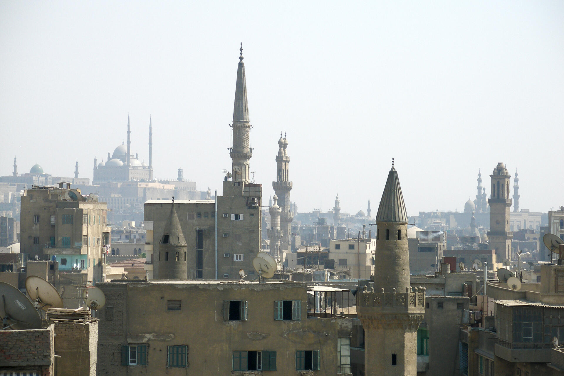
Historic Cairo, also known as Islamic Cairo or Medieval Cairo, is a captivating testament to the rich history and cultural diversity of Egypt. This ancient city, located within the modern urban area of Cairo, was founded in the 10th century and played a pivotal role in the Islamic world, reaching its golden age in the 14th century. In 1979, Historic Cairo was inscribed as a UNESCO World Heritage Site, recognizing its significant historical and architectural value.
More to come…UNESCO Description of the World Heritage Site
Tucked away amid the modern urban area of Cairo lies one of the world's oldest Islamic cities, with its famous mosques, madrasas, hammams and fountains. Founded in the 10th century, it became the new centre of the Islamic world, reaching its golden age in the 14th century.
UNESCO Justification of the World Heritage Site
Criterion (i): The great monuments of Historic Cairo are a unique ensemble of architectural and artistic masterpieces which stand tall in the sky of Cairo. Each of them expresses rare artistic, aesthetic and architectural value, which might be enough for each to be considered as of outstanding global importance in the history of art and architecture in the world. Together they are an ensemble that reflects the highpoints of Tulunid, Fatamid, and Mamluk architecture. The mosque of Ahmed ibn Tulun (876-879 AD), with its spiral minaret and symmetrical arches opening on to a vast square court, is an outstanding example of early Islamic architecture from the 9th and 10th centuries. The distinctive Fatimid architecture (969–1171 AD) is reflected in the city fortifications and gates, Al-Azhar, Al-Hakim, Al-Aqmar and Salih Tala'I mosque, and mausoleums and shrines. The extraordinary Bahri Mamluk (1250-1382 AD) and Burgi Mamluk (1382-1517 AD) monuments reign triumphant above the skyline of Cairo, the refinement of their colourful architecture, boldly defined, original and unexpected, is characterised by domes with Persian arches, minarets with finely chiselled cantilevers, tall facades with pointed arches, and balconies mounted on stalactites, like those in the complex of Sultan Qalawun, the monuments of al-Nasir Mohammad, the Madrasa of Sultan Hasan, Bimaristan al-Mu’ayyadiyah and the complex of Sultan Al-Ghori.
Criterion (v): Historic Cairo is an outstanding example of cohesive urban fabric, expressing the long coexistence of different cultures and human interaction with the environment. Its settlement was shaped by Cairo’s strategic location at the tip of the Delta, between the River Nile (east) and the Moqattam Hill (west). The historic southern port of Al-Fustat, strongly connected to the River Nile, fostered the historic development of trade with Europe, while an aqueduct, Sur Megra El-Ayoun, dating back to medieval times, created a link between the city and the river that made possible an extensive network of canals, cisterns, and sabils. The 10th century Fatimid planning centre inside the fortifications is the nucleus of the city. Its construction extended in the form of lanes representing residential Harats for different sects, races and tribes, which allowed for future development. This Fatamid Plan was greatly enlarged in the Mamluk era to become a manifestation of the application of Islamic jurisprudence in planning and spatial organization, while the Ottomans maintained the medieval urban patterns. The building of a new Cairo in the 19th century allowed Historic Cairo to remain largely intact as an outstanding example of medieval town planning. Since the second half of the 19th century, development has involved the filling up of canals to provide space for new streets and settlements. The historic city has become vulnerable due to these pressures, and from the widespread use of new architectural models and changes in original functions (such as caravanserai, madrasas and sabils).
Criterion (vi): The historic centre of Cairo constitutes an impressive material witness to the international importance of the city’s political, strategic, intellectual and commercial levels during the medieval period. Al-Azhar has been a leading theological and religious academic centre for the entire Islamic world since its foundation in 970 AD and continues to have a strong and continuing impact. Several prominent mausoleums are devoted to Imams or saints renowned by many Muslims such as the shrines of Al-Hussain, Sayyida Nafisa, Sayyida Aisha and Sayyida Ruqayya, while the Amr Ibn Al-Ass Mosque, Nilometer, Ahmed Ibn Tulun Mosque, Azhar Mosque, Qalawun Bimaristan, Sultan Hassan Madrassa, Sultan Barquq Mosque-Madrasa Complex, Mahmoud Al-Kurdi Madrasa, and Mawlawi Tekkiya are all exceptional witnesses to the pioneering ideas in medicine, chemistry, biology, water engineering and jurisprudence which combined to make Historic Cairo a major destination in the Islamic world.
Encyclopedia Record: Islamic Cairo
Islamic Cairo, or Medieval Cairo, officially Historic Cairo, refers mostly to the areas of Cairo, Egypt, that were built from the Muslim conquest in 641 CE until the city's modern expansion in the 19th century during Khedive Ismail's rule, namely: the central parts within the old walled city, the historic cemeteries, the area around the Citadel of Cairo, parts of Bulaq, and Old Cairo which dates back to Roman times and includes major Coptic Christian monuments.Additional Site Details
Area: 523.66 hectares
Number of Components: 5
(v) — Outstanding example of traditional human settlement
(vi) — Directly associated with events or living traditions
Coordinates: 30.05 , 31.26111