World Heritage Identification Number: 819
World Heritage since: 1997
Category: Cultural Heritage
WHE Type: Historic Cities & Urban Areas
Transboundary Heritage: No
Endangered Heritage: No
Country: 🇳🇱 Netherlands (Kingdom of the)
Continent: Europe
UNESCO World Region: Europe and North America
Map
The Historic Area of Willemstad, Inner City and Harbour, Curaçao: A Unique Blend of Architectural Styles
The Historic Area of Willemstad, Inner City and Harbour, Curaçao, is a remarkable testament to the rich cultural and architectural history of this Caribbean island. Established in 1634 by the Dutch, Willemstad has since evolved into a vibrant city that seamlessly blends various architectural influences. This blend of styles earned it a place on the prestigious UNESCO World Heritage List in 1997.
More to come…UNESCO Description of the World Heritage Site
The people of the Netherlands established a trading settlement at a fine natural harbour on the Caribbean island of Curaçao in 1634. The town developed continuously over the following centuries. The modern town consists of several distinct historic districts whose architecture reflects not only European urban-planning concepts but also styles from the Netherlands and from the Spanish and Portuguese colonial towns with which Willemstad engaged in trade.
UNESCO Justification of the World Heritage Site
Criterion (ii): The Historic Area of Willemstad is a colonial ensemble in the Caribbean, which illustrates the organic growth of a multicultural community over three centuries. It also represents a remarkable historic port town in the Caribbean in the period of Dutch expansion with significant town planning and architectural qualities.
Criterion (iv): The four historic urban districts of Historic Willemstad show the subsequent stages of historical development over the course of centuries of the city. The city can be easily read and used as a textbook for its historical and cultural development.
Criterion (v): The historical urban fabric and the historical architecture are based on examples of European traditions that are transferred to the New World. Influences of the Americas and Africa and cultural elements of the region transformed the European elements into a typical Caribbean development.
Encyclopedia Record: Willemstad
Willemstad is the capital and largest city of Curaçao, an island in the southern Caribbean Sea that is a constituent country of the Kingdom of the Netherlands. It was the capital of the Netherlands Antilles prior to that entity's dissolution in 2010. The city accounts for around 90% of Curaçao's population, with 136,660 inhabitants as of 2011. The historic centre of the city consists of four quarters: the Punda and Otrobanda, which are separated by the Sint Anna Bay, an inlet that leads into the large natural harbour called the Schottegat, as well as the Scharloo and Pietermaai Smal quarters, which are across from each other on the smaller Waaigat harbour. Willemstad is home to the Curaçao synagogue, the oldest surviving synagogue in the Americas. The city centre, with its unique architecture and harbour entry, has been designated a UNESCO World Heritage Site.Additional Site Details
Area: 86 hectares
Number of Components: 1
(iv) — Outstanding example of a type of building or landscape
(v) — Outstanding example of traditional human settlement
Coordinates: 12.10194 , -68.90222
Image
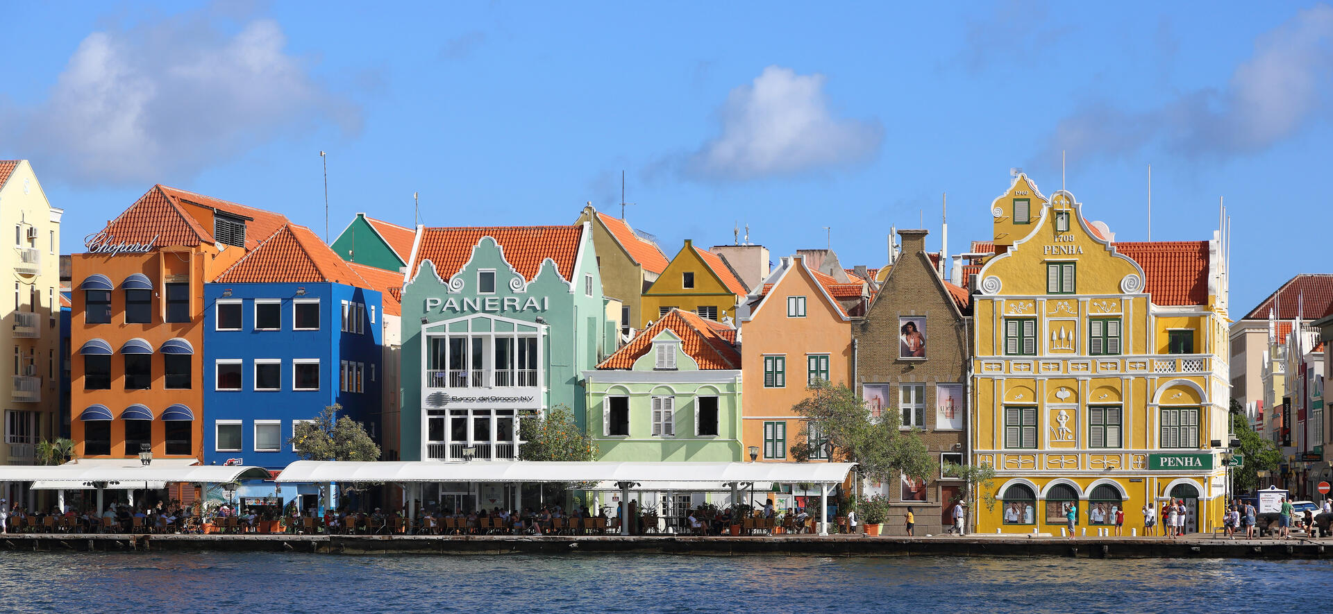
© Martin Falbisoner, CC BY-SA 4.0 Resized from original. (This derivative is under the same CC BY-SA license.)
World Heritage Research
Discover scientific research and academic studies that deepen our understanding of Historic Area of Willemstad, Inner City and Harbour, Curaçao from its history and significance to its conservation, management, and contemporary challenges.
-
Leveraging a Street Festival for Lasting Transformation in a UNESCO World Heritage Neighbourhood
Temporary cultural events, such as street festivals, can drive lasting urban revitalization in historic neighborhoods, even when their immediate impacts are often overlooked. A qualitative study of the Kaya Kaya festival in Otrobanda, Curaçaoreveals how such initiatives temporarily repurpose vacant properties and public spaces to foster artistic appeal, economic activity, and community engagement. Through interviews and urban planning theories, researchers demonstrate that these events generate long-term social, economic, and physical benefits, challenging the assumption that their effects are fleeting. The case highlights strategic opportunities for policymakers, developers, and investors to leverage short-term cultural interventions as catalysts for sustainable neighborhood transformation.
Regales, C., & Simons, I. (2026). Leveraging a Street Festival for Lasting Transformation in a UNESCO World Heritage Neighbourhood. Urban Planning, 11. https://doi.org/10.17645/up.11659
View Publication Record | Read Publication -
Simplifying the Past: Willemstad's Historic and Historicizing Architecture
Willemstad, Curaçao's UNESCO-listed historic area, faces a growing erosion of its multicultural architectural heritage due to modern developments that prioritize Dutch contributions over its diverse past. The study reveals how the city's unique blend of Dutch-gabled townhouses, classicizing villas, and Curaçaoan aesthetics—rooted in its mixed population of Dutch settlers, Iberian Jews, and enslaved Africans—has been selectively preserved, often overshadowing its global influences. By analyzing architectural trends from the 20th and 21st centuries, the research highlights how the townhouse form, once emblematic of this multiculturalism, is increasingly framed as solely Dutch vernacular architecture. The findings challenge the narrative simplification that undermines Willemstad's rich, layered history.
Kehoe, M. L. (2025). Simplifying the Past: Willemstad’s Historic and Historicizing Architecture. Trade, Globalization, and Dutch Art and Architecture, 165–206. https://doi.org/10.5117/9789463723633_ch05
View Publication Record | Read Publication -
Een eeuwenlange strijd tegen droogte en teloorgang
Curaçao's landscape, primarily a plantation system excluding Willemstad’s inner city, reflects centuries of adaptation to drought and economic decline. This study reveals that plantation owners employed diverse strategies—such as diversified crops, saltpan creation, and urban trade—to mitigate drought and economic pressures. However, by the late 19th century, mineral exploration and 20th-century abandonment due to urban migration (accelerated by industrialization) led to widespread neglect. Uncontrolled urbanization, privatization of public spaces, and the rise of gated residential areas have further transformed this landscape, erasing its historical identity and exacerbating inequality. A potential UNESCO World Heritage nomination could offer new preservation opportunities for this culturally significant but endangered landscape.
KOREN, D. (2020). Een eeuwenlange strijd tegen droogte en teloorgang. Tijdschrift Voor Historische Geografie, 5(3), 131–151. https://doi.org/10.5117/thg2020.3.001.kore
View Publication Record | Read Publication -
Slavernijverleden werpt schaduw vooruit
A potential UNESCO World Heritage nomination for the plantation system of western Curaçao could safeguard its unique but eroding landscape, but success hinges on addressing historical controversies, particularly slavery. The study argues that a nomination should acknowledge the dark aspects of history and shift focus from architecture to cultural landscapes, including diverse modes of production like salt, water, and mining. It also emphasizes the need for broader popular support and systematic research to bridge knowledge gaps. Two strategies are proposed: a new nomination or extending the existing Willemstad site, which could highlight the city's multicultural heritage.
KOREN, D. (2020). Slavernijverleden werpt schaduw vooruit. Tijdschrift Voor Historische Geografie, 5(3), 152–168. https://doi.org/10.5117/thg2020.3.002.kore
View Publication Record | Read Publication